Gickelsberg (Jizera Mountains)
| Výhledy / Guślarz | ||
|---|---|---|
| height | 569 m | |
| location | between Jasna Góra and Horní Vítkov on the Czech-Polish border | |
| Mountains | Jizera Mountains | |
| Coordinates | 50 ° 51 '41 " N , 14 ° 57' 53" E | |
|
|
||
| rock | Basalt dome on a granite ridge | |
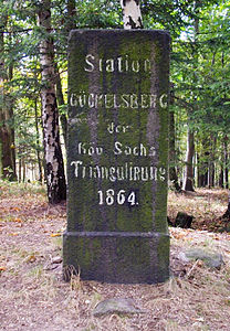
| particularities | Triangulation point No. 38 of the Royal Saxon triangulation | |
|
Triangulation stone |
||
The Gickelsberg (Czech Výhledy , Polish Guślarz ) is a mountain in the southwest of the Jizera Mountains . It is located five kilometers north of Chrastava in the border area between the Czech Republic and Poland .
geography
The Gickelsberg is the most south-westerly foothills of the Jizera Mountains at the transition to the Zittau Basin . Its summit is on Bohemian territory, and the state border with Poland runs below it to the north. The Graniczny Wierch / Lysý vrch ( Kahleberg , 643 m) rises to the east and the Vítkovský kopec ( Wittigberg , 503 m) with the Skanzen Curia Vitkov . To the west lies the Kamenný vrch ( Steinberg , 400 m). The source of the Jasný potok lies in the east, and the Václavický potok rises to the southwest . To the south is the valley of the Vítkovský potok ( Wittigbach ).
Surrounding villages are Jasna Góra in the north, Markocice in the northeast, Vysoký in the east, Horní Vítkov in the southeast, Dolní Vítkov in the south, Václavice in the southwest, Uhelná and Białopole in the west and Opolno Zdrój in the northwest.
geology
The northern side of the mountain on Polish territory is made of granite , the southern part with the summit is made of basalt . On the summit, south of the location of the former inn, there is a rock tower made of horizontally mounted basalt columns.
history
The mountain on the border between Upper Lusatia and Bohemia developed into a popular excursion destination because of its view of the Zittau basin and the Neißetal . His German (from gucken ) and the Czech name also refer to this . During his journey through northern Bohemia, Emperor Joseph II rode the mountain on September 17, 1774.
On the summit near the border in Bohemian territory, a managed refuge was built in the 1850s. During the German War , the Prussians occupied the Gickelsberg in 1866 and burned the hut down because the innkeeper is said to have signaled the approach of the enemy to the Austrians by hoisting flags. In 1872 a master baker from Lichtenberg built a new inn on the mountain. The owner of the Reibersdorf estate , Kurt Heinrich Ernst von Einsiedel , gave the landlord the oil painting "The Hermit", which was a special attraction in the guest room until 1896. The small mountain hut was a destination for day trippers from Lichtenberg and Bad Oppelsdorf , mainly because of the Bohemian beer . After the Second World War, the border that led to Poland was closed and border tourism ceased. The hut was demolished.
Attractions
- Basalt stock with horizontal pillars
- Wooden viewing platform with a view of the Jeschken
- From the mountain there is a wide view over the Zittau basin with open pit and power station Turów to the Landeskrone and the Jizera Mountains and over the valley of the Lusatian Neisse to the Jeschkengebirge , Lusatian Mountains and Zittau Mountains .


