Gjerstad
| coat of arms | map | |
|---|---|---|

|
|
|
| Basic data | ||
| Commune number : | 4211 | |
| Province (county) : | Agder | |
| Administrative headquarters: | Gjerstad | |
| Coordinates : | 58 ° 53 ' N , 9 ° 1' E | |
| Surface: | 322.14 km² | |
| Residents: | 2,428 (Feb 27, 2020) | |
| Population density : | 8 inhabitants per km² | |
| Language form : | neutral | |
| Website: | ||
| traffic | ||
| Railway connection: | Sørlandsbanen | |
| politics | ||
| Mayor : | Inger Haldis Løite ( Ap ) (2015) | |
| Location in the province of Agder | ||

|
||
Gjerstad is a municipality in the Norwegian Fylke (province) Agder with 2428 inhabitants (as of February 27, 2020). The municipality is located in the southeast of the country.
geography
Gjerstad is located in the east of the southern Norwegian province of Agder, on the border with Vestfold og Telemark . There are two Tettsted towns in the municipality , namely Gjerstad with 264 inhabitants and Eikeland with 587 inhabitants (as of 2019). The village of Gjerstad serves as the administrative center of the municipality. Lake Gjerstadvatnet is located in the center of the municipality . The highest elevation is at 587 moh. the Solhomfjell.
The inhabitants of the municipality are called Gjersdøl or Gjersdøling . The official language variant is neither Bokmål nor Nynorsk , as Gjersdal, like many other municipalities in the province, is one of the municipalities that are neutral on this issue.
history
Gjerstad commune was founded in 1837 when the communes were established in Norway. Since then the borders have remained unchanged. In the village of Gjerstad there is a wooden church that was built in 1848. Until the end of 2019, the municipality belonged to the then Aust-Agder province . As part of the nationwide regional reform on January 1, 2020, this was transferred together with Vest-Agder to the newly created Fylke Agder, whereby Gjerstad is now part of Agder.
economy
The most important industrial sectors of the municipality is the machine industry. Forestry was also of great importance for a long time, but the timber harvest declined over time. The agriculture depends largely on the cattle and sheep from. In 2019, over half of the employees worked outside the municipality.
coat of arms
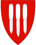
The coat of arms, officially used since 1986, shows three silver knives on a red background. It should represent the traditional knife production of the community.
Famous pepole
- Niels Henrik Abel (1802–1829), mathematician, grew up in Gjerstad
- Georg Østerholt (1892–1982), Nordic skier
Web links
- Gjerstad in the store norske leksikon (Norwegian)
- Facts about Gjerstad from Statistisk sentralbyrå (Norwegian)
Individual evidence
- ↑ Statistisk sentralbyrå - Befolkning
- ↑ Tettsteders following og areal. In: ssb.no. Statistisk sentralbyrå , December 20, 2019, accessed May 27, 2020 (Norwegian).
- ^ Gjerstadvatnet. Norgeskart, accessed May 27, 2020 (Norwegian).
- ↑ Høyeste fjelltopp i hver commune. In: Kartverket. September 1, 2015, accessed on May 27, 2020 (Norwegian Bokmål).
- ↑ Innbyggjarnamn. Språkrådet, accessed May 27, 2020 (Norwegian).
- ↑ Forskrift om målvedtak i Kommunar og fylkeskommunar (målvedtaksforskrifta). In: Lovdata. January 6, 2020, accessed May 27, 2020 (Norwegian).
- ↑ a b c Geir Thorsnæs: Gjerstad . In: Store norske leksikon . November 1, 2018 (Norwegian, snl.no [accessed May 27, 2020]).
- ^ Gjerstad kirke, Gjerstad. Kirkesøk, accessed May 27, 2020 (Norwegian).
- ↑ Nye kommune- og fylkesnummer fra 2020. In: regjeringen.no . Kommunal- og moderniseringsdepartementet, October 27, 2017, accessed on May 27, 2020 (Norwegian).
- ↑ Pendlingsstrømmer. Statistics Norway, accessed May 27, 2020 (Norwegian).
- ↑ Godkjenning av våpen og flagg, Gjerstad commune, Aust-Agder. In: Lovdata. April 18, 1986, Retrieved May 27, 2020 (Norwegian Nynorsk).
