Glauberg (Glauburg)
|
Glauberg
Community of Glauburg
Coordinates: 50 ° 18 ′ 53 ″ N , 9 ° 0 ′ 0 ″ E
|
|
|---|---|
| Height : | 130 m above sea level NHN |
| Area : | 5.47 km² |
| Residents : | 1357 (2013) |
| Population density : | 248 inhabitants / km² |
| Incorporation : | July 1, 1971 |
| Postal code : | 63695 |
| Area code : | 06041 |
|
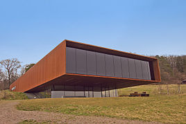
Museum building on Glauberg
|
|
Glauberg is a district of the community Glauburg in the Wetteraukreis in Hesse .
Geographical location
Glauberg is located in the eastern Wetterau, west of the Büdinger Forest and north of the Ronneburger Hügelland at the confluence of the Bleichenbach into the Nidder and at the foot of the Glauberg , a 276 meter high basaltic ridge that is considered to be the foothills of the Vogelsberg and namesake of the place.
The district area is given for 1961 with 547 hectares, of which 99 hectares are forest.
To the north of Glauberg is another district of Glauburg, about one kilometer away, with Stockheim . In addition, Glauberg is surrounded by the towns of Düdelsheim in the southeast, Enzheim in the south, Heegheim in the southwest and Nieder-Mockstadt in the east.
history
Early history
On the 800-meter-long plateau of the Glauberg you can find the remains of a fortress that dates back at least to the Celtic times with extensive ring wall and connecting wall systems as well as forts. At the end of the 20th century, a Celtic princely grave was discovered on Glauberg . The sensational find made national headlines as a Celtic prince from Glauberg .
middle Ages
The name of the place can be traced back to the years 750 to 802 as Glopurch . In the Codex Laureshamensis III the location is mentioned in marca Gloubero 844 to 846.
The imperial castle Glauberg is mentioned in 1247 . It was located on the northeast part of the plateau but was destroyed in the second half of the 13th century.
Modern times
Glauberg belonged to the Stolberg-Gedern dominion . Here was Solmser Land Law of 1571 by customary law , but only partially rezipiert . This applied in particular to the areas of guardianship law , inheritance and matrimonial property law . Moreover, the applied Common Law . It was not until January 1, 1900, when the Civil Code , which was uniformly valid throughout the German Reich , that the old particular law was suspended .
When the male line of the Princes zu Stolberg-Gedern died out in 1804, Glauberg came to the Count's main line Stolberg-Wernigerode, which had to cede its sovereignty here to the Landgraviate of Hesse-Darmstadt with the adoption of the Rhine Confederation Act . Glauberg then belonged to the Grand Duchy of Hesse , from 1918: People's State of Hesse . In 1945 it became part of Greater Hesse , and in 1946 of the State of Hesse .
In the course of administrative reform in Hesse , the community Glauberg concluded with the neighboring municipality Stockheim on 1 July 1971. voluntarily merged to Glauburg together .
Population development
The number of inhabitants in the 19th century ranged between 510 and 590. Due to immigration after the Second World War, the number soared to 1,120 in 1946 and rose to 1,357 in 2003.
Culture
The Keltenmuseum Keltenwelt am Glauberg is located on the southern slope of the Glauberg plateau .
traffic
rail
In Glauberg, the Glauburg-Glauberg stop is on the Bad Vilbel – Glauburg-Stockheim railway line .
Street
The state road L 3183 runs through Glauberg as the main road and Enzheimer road . From there, the district road K 237 branches off as Heegheimer Straße and crosses the Nidder meadows with two bridges over the Nidder and the Mühlbach .
Web links
- Web presence of the community of Glauburg
- Glauberg, Wetterau district. Historical local dictionary for Hessen. In: Landesgeschichtliches Informationssystem Hessen (LAGIS).
- Literature on Glauberg in the Hessian Bibliography
Individual evidence
- ↑ a b "Glauberg, Wetteraukreis". Historical local lexicon for Hesse (as of December 8, 2014). In: Landesgeschichtliches Informationssystem Hessen (LAGIS). Hessian State Office for Historical Cultural Studies (HLGL), accessed on April 17, 2016 .
- ↑ Numbers, data, facts from the community of Glauburg ( Memento of the original from March 11, 2016 in the Internet Archive ) Info: The archive link was inserted automatically and has not yet been checked. Please check the original and archive link according to the instructions and then remove this notice. , accessed July 2016
- ↑ The Celtic world on Glauberg
- ↑ Stengel, UB Kloster Fulda, p. 449 no. 375.
- ↑ Arthur Benno Schmidt : The historical foundations of civil law in the Grand Duchy of Hesse . Curt von Münchow, Giessen 1893, p. 108, note 36 and p. 25, note 81, as well as the enclosed map.
- ^ Municipal reform in Hesse: mergers and integrations of municipalities from June 21, 1971 . In: The Hessian Minister of the Interior (ed.): State Gazette for the State of Hesse. 1971 No. 28 , p. 1117 , item 988; Paragraph 13. ( Online at the information system of the Hessian State Parliament [PDF; 5.0 MB ]).
- ^ Federal Statistical Office (ed.): Historical municipality directory for the Federal Republic of Germany. Name, border and key number changes in municipalities, counties and administrative districts from May 27, 1970 to December 31, 1982 . W. Kohlhammer, Stuttgart / Mainz 1983, ISBN 3-17-003263-1 , p. 352 .

