
Gmina Miejska Górka
| Gmina Miejska Górka | |||
|---|---|---|---|

|
|
||
| Basic data | |||
| State : | Poland | ||
| Voivodeship : | Greater Poland | ||
| Powiat : | Rawicki | ||
| Geographic location : | 51 ° 39 ' N , 16 ° 57' E | ||
| Residents : | s. Gmina | ||
| Postal code : | 63-910 | ||
| Telephone code : | (+48) 65 | ||
| License plate : | PRE | ||
| Economy and Transport | |||
| Street : | DK36 Lubin - Ostrów | ||
| DW434 Rawicz - Poznan | |||
| Next international airport : | Wroclaw | ||
| Gmina | |||
| Gminatype: | Urban-and-rural parish | ||
| Gmina structure: | 17 school authorities | ||
| Surface: | 103.6 km² | ||
| Residents: | 9288 (Jun. 30, 2019) |
||
| Population density : | 90 inhabitants / km² | ||
| Community number ( GUS ): | 3022033 | ||
| Administration (as of 2014) | |||
| Mayor : | Karol Skrzypczak | ||
| Address: | Rynek 33 63-910 Miejska Górka |
||
| Website : | www.miejska-gorka.pl | ||

The Miejska Górka is a city and country community in Rawicz County of Greater Poland Voivodeship in Poland . Its seat is the city of the same name ( German Görchen ) with about 3200 inhabitants.
geography
_location_map.png)
The municipality is located in the south of the voivodeship. The Lower Silesian Voivodeship is about six kilometers away. The voivodeship capital Posen is about 80 kilometers north, Leszno (Lissa) about 30 kilometers northwest, Wroclaw 60 kilometers south and the district town Rawicz (Rawitsch) five kilometers southwest. Neighboring communities are the communities Poniec , Krobia and Pępowo in the north, Jutrosin in the east, Pakosław in the south, Rawicz in the southwest and Bojanowo in the northwest.
The 40-kilometer-long Dąbroczna, a tributary of the Orla (Horle) , is one of the rivers .
The community has an area of 103.6 km², 88 percent of which is used for agriculture. Only 18.83 hectares are forested.
history
Interrupted by the German occupation in the Second World War from 1919 to 1975, today's municipal area belonged to the Poznan Voivodeship, with different layouts. - The German minority was expelled after the World War .
The rural community of Miejska Górka was dissolved in 1954 and repeatedly transformed into different gromadas . From these, the rural community was re-formed on January 1, 1973. From 1975 to 1998 the municipality belonged to the Leszno Voivodeship . The powiat was dissolved during this time. Urban and rural municipality Miejska Górka were merged in 1990/1991 to form urban and rural municipality. Since 1999 this has belonged to the Greater Poland Voivodeship and to the re-established Powiat Rawicki.
structure
The town and country community (gmina miejsko-wiejska) Miejska Górka with 30,339 inhabitants (as of June 30, 2019) includes the town itself and 18 villages (German names, official until 1945) with 17 school offices (sołectwa):
- Dąbrowa (382)
- Dłoń (618)
- Gostkowo (378, Gostkowo )
- Karolinki (257, Chocicza )
- Kołaczkowice (307)
- Konary (1183, Konary , also Korngut )
- Niemarzyn (411, Niemarzyn )
- Oczkowice (250, Oczkowice )
- Piaski-Zalesie (150 & 21)
- Roszkowo (266, Roszkowo )
- Roszkówko (138, Roszkowko )
- Rozstępniewo (233)
- Rzyczkowo (134, Rzyczkowo )
- Sobiałkowo (862)
- Topólka (62)
- Woszczkowo (108, Woszczkowo )
- Zakrzewo (284, Zakrzewo , 1939–1945 Buschdorf )
Smaller villages in the municipality are Annopol (0), Jagodnia (7), Melanowo (37) and Zmysłowo (46).
Listed sights (selection)
In the places of the municipality are among other things under monument protection :
- Castle in Dłoń (1910), Chinese pavilion, outbuildings, park and manor buildings, 19th – 20th centuries century
- Church of St. Nicholas (1609) in Miejska Górka with a cemetery
- Windmill in Miejska Górka, 1772
- Wooden church in Zakrzewo, 1728.
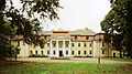
Castle in Dłoń
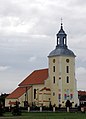
Church in Miejska Górka

Wooden church in Zakrzewo

Windmill in Miejska Górka


_ID_655695.jpg)
_ID_655681.jpg)
traffic
The national road DK36 leads from Lubin (Lüben) in the west via Rawicz (Rawitsch) and Miejska Górka to Ostrów Wielkopolski (Ostrowo) in the east. The voivodship road DW434 leads from Rawicz (Rawitsch) via Jagodnia and Roszkówko to Kleszczewo (Wilhelmshorst) .
The nearest long-distance train station is in the district town of Rawicz on the railway line from Poznan to Wroclaw .
The nearest international airport is Wroclaw .
Web links
- City and municipality website (Polish)
Footnotes
- ↑ population. Size and Structure by Territorial Division. As of June 30, 2019. Główny Urząd Statystyczny (GUS) (PDF files; 0.99 MiB), accessed December 24, 2019 .
- ↑ a b regioset.pl: data on the municipality (Polish, accessed on May 27, 2020)
- ↑ miejska-gorka.pl: Dane statystyczne. (Polish, accessed May 12, 2020)
- ↑ Population figures as of June 30, 2019. In: Dane statystyczne. (Polish, accessed May 12, 2020)
- ↑ The Historical Place Directory
- ↑ Registered in the list of monuments of the Greater Poland Voivodeship under the number 1424 / A on April 11, 1973.
- ↑ Registered in the list of monuments of the Masovian Voivodeship under the number 1014 / A on May 25, 1987.
- ↑ Registered in the list of monuments of the Greater Poland Voivodeship under number 30/130 on December 21, 1932.
- ↑ Registered in the list of monuments of the Greater Poland Voivodeship under the number 674 / A on June 4, 2008.
- ↑ Registered in the list of monuments of the Greater Poland Voivodeship under the number 1108 / A on May 23, 1988.
- ↑ Registered in the list of monuments of the Greater Poland Voivodeship under the number 166/608 on February 1st.