
Gmina Złoczew
| Gmina Złoczew | |||
|---|---|---|---|

|
|
||
| Basic data | |||
| State : | Poland | ||
| Voivodeship : | Łódź | ||
| Powiat : | Sieradzki | ||
| Geographic location : | 51 ° 25 ′ N , 18 ° 36 ′ E | ||
| Residents : | s. Gmina | ||
| Postal code : | 98-270 | ||
| Telephone code : | (+48) 43 | ||
| License plate : | IT I | ||
| Economy and Transport | |||
| Street : | S8 Wroclaw - Łódź - Warsaw | ||
| DK45 Złoczew– Racibórz | |||
| DW482 Kępno - Sieradz | |||
| Rail route : | - | ||
| Next international airport : | Łódź | ||
| Gmina | |||
| Gminatype: | Urban-and-rural parish | ||
| Gmina structure: | 20 school offices | ||
| Surface: | 118.02 km² | ||
| Residents: | 7180 (June 30, 2019) |
||
| Population density : | 61 inhabitants / km² | ||
| Community number ( GUS ): | 1014113 | ||
| Administration (as of 2018) | |||
| Mayor : | Dominik Drzazga | ||
| Address: | ul.Szeroka 17 98-270 PLN |
||
| Website : | zloczew.pl | ||

The Gmina Złoczew is an urban-and-rural municipality in the powiat Sieradzki of the Łódź Voivodeship in Poland . Its seat is the city of the same name with about 3400 inhabitants.
geography
_location_map.png)
The municipality is located in the southwest of the voivodeship. The city of Łódź is about 60 kilometers northeast, the district town of Sieradz (1941: Schieratz ) 15 kilometers north. Neighboring communities are the communities Brąszewice in the northwest and Brzeźnio and Burzenin in the north, Konopnica in the east, Ostrówek in the south, Lututów in the southwest and Klonowa in the west.
The most important river is the 44 km long Oleśnica in the south of the municipality, a left tributary of the Warta . In parts it forms part of the municipal boundary.
The community has an area of 118 km², 68 percent of which is used for agriculture and 23 percent for forestry.
history
Today's municipal area belonged to the powiat Sieradzki and since 1945 to the Łódź Voivodeship in the former layout. The rural community of Złoczew, which was dissolved in 1954, was re-created on January 1, 1973 from various gromadas . Like the city, it came to the Sieradz Voivodeship from 1975 to 1998 . The powiat was dissolved during this time.
The town and country municipality of Złoczew were merged in 1990/1991 to form the town and country municipality. This came in 1999 to the Łódź Voivodeship as it is today and to the re-established powiat. The capital of the municipality had in 1919, which in 1870 but knew town charter recovered.
structure
The urban and rural community (gmina miejsko-wiejska) Złoczew with 7,180 inhabitants (as of June 30, 2019) consists of the city itself and 20 villages with school boards (sołectwa). These are:
- Borzęckie
- Broszki
- Bujnów
- Czarna
- Dąbrowa Miętka
- Emilianów
- Gronówek
- Grójec Mały
- Grójec Wielki
- Kamasze
- Łeszczyn
- Miklesz
- Potok
- Robaszew
- Stanisławów
- Stolec
- Szklana Huta
- Uników
- Wandalin
- Zapowiednik
Smaller settlements are Biesiec, Przylepka and two forest settlements called Grójec Wielki.
Listed sights
- Church św. Stanisława in Uników, built in 1875
- Church św. Andrzeja in Złoczew, 1614–1617 / 18. century
- Camaldolese - Monastery with outbuildings in Złoczew (. 17th-19th centuries)
- Manor house and outbuildings in Złoczew (1616, 18/19 centuries).

Church in Uników

Church św. Andrzeja

Camaldolese monastery
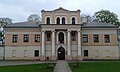
Manor house in Złoczew
_ko%C5%9Bci%C3%B3%C5%82.JPG)


traffic
The main traffic connection is the S8 expressway , which leads to Wroclaw in the south-west and via Łódź and Warsaw to Białystok in the north-west. The national road DK45 leads from the capital of the municipality to Racibórz in the Silesian Voivodeship . The DW482 voivodeship road leads from Kępno (Kempen) in the Greater Poland Voivodeship via Wieruszów (Weruschau) and Złoczew to Sieradz and Łódź. The DW477 is 2.34 kilometers one of the shortest provincial roads in the country. It connects Złoczew and the DW482 with the connection of the S8 and the DK45.
The nearest train station is Wieluń Dąbrowa on the Herby – Oleśnica railway line . - Łódź is the nearest international airport.
Web links
- City and municipality website (Polish)
Individual evidence
- ↑ population. Size and Structure by Territorial Division. As of June 30, 2019. Główny Urząd Statystyczny (GUS) (PDF files; 0.99 MiB), accessed December 24, 2019 .
- ↑ a b regioset.pl: data on the municipality (Polish, accessed on May 29, 2020)
- ↑ zloczew.pl: Sołectwa . (Polish, accessed March 21, 2020)
- ↑ Registered in the list of monuments of the Łódź Voivodeship under number 11 on August 22, 1977.
- ↑ Registered in the list of monuments of the Łódź Voivodeship under numbers 875 (December 28, 1967) and 100 (October 1, 1986).
- ↑ Registered in the list of monuments of the Łódź Voivodeship under the numbers 102 / 876-105 / 879 on December 28, 1967.
- ↑ Registered in the list of monuments of the Łódź Voivodeship under the numbers 106 / 876-109 / 881 on December 28, 1967.
