
Gmina Zelów
| Gmina Zelów | |||
|---|---|---|---|

|
|
||
| Basic data | |||
| State : | Poland | ||
| Voivodeship : | Łódź | ||
| Powiat : | Bełchatowski | ||
| Geographic location : | 51 ° 28 ′ N , 19 ° 13 ′ E | ||
| Residents : | s. Gmina | ||
| Postal code : | 97-425 | ||
| Telephone code : | (+48) 44 | ||
| License plate : | EBE | ||
| Economy and Transport | |||
| Street : | DW483 | ||
| DW484 | |||
| DW473 | |||
| Next international airport : | Łódź Airport | ||
| Gmina | |||
| Gminatype: | Urban-and-rural parish | ||
| Gmina structure: | 35 school offices | ||
| Surface: | 167.08 km² | ||
| Residents: | 14,995 (Jun. 30, 2019) |
||
| Population density : | 90 inhabitants / km² | ||
| Community number ( GUS ): | 1001083 | ||
| Administration (as of 2018) | |||
| Mayor : | Tomasz Jachymek | ||
| Address: | ul. Żeromskiego 28 97-425 Zelów |
||
| Website : | www.zelow.pl | ||

The Gmina Zelów [ ˈzɛluf ] is an urban-and-rural municipality in the powiat Bełchatowski of the Łódź Voivodeship in Poland . Its seat is the city of the same name ( German Zelow ) with about 7600 inhabitants.
geography
_location_map.png)
The municipality is located in the center of the voivodeship, about 30 kilometers south of the capital Łódź . The district town of Bełchatów is about ten kilometers south-east. Neighboring municipalities are Bełchatów , Buczek , Dłutów , Drużbice , Kluki , Łask , Sędziejowice , Szczerców and Widawa .
The community has an area of 167 km², 68 percent of which is used for agriculture and 25 percent for forestry.
history
Zelów received city rights in 1957 . The rural community was re-established in 1973, from 1954 to 1972 it was divided into Gromadas . From 1975 to 1998 the rural community belonged to the Piotrków Voivodeship .
Town twinning
In 1993 the municipality entered into a town partnership with the integrated municipality and town of Neuenhaus in Lower Saxony.
structure
The urban and rural community of Zelów (gmina miejsko-wiejska) with 14,995 inhabitants (as of June 30, 2019) includes the following 35 villages with a school administration office (sołectwo) in addition to the city itself :
- Bocianicha
- Bujny Księże
- Bujny Szlacheckie
- Chajczyny
- Dąbrowa
- Grabostów
- Grębociny
- Ignaców
- Jamborek
- Janów
- Yes
- Karczmy
- Kociszew
- Kolonia Kociszew
- Kolonia Łobudzice
- Kolonia Pożdżenice
- Kurówek
- Łęki
- Łobudzice
- Mauryców
- Ostoja
- Pawłowa
- Pożdżenice
- Pszczółki
- Pukawica
- Sobki
- Sromutka
- Walewice
- Wola Pszczółecka
- Wygiełzów
- Wypychów
- Zabłoty
- Zagłówki
- Zalesie
- Zelówek
Other smaller towns in the municipality are:
- Faustynów
- Grabostów-Bominy
- Karczmy-Kolonia
- Kociszew A.
- Kolonia Grabostów
- Kolonia Ostoja
- Krześlów
- Kurów
- Kuźnica
- Łęki-Kolonia
- Marszywiec
- Nowa Wola
- Podlesie
- Przecznia
- Tosin
- Źródła
Representation in the Council
The 35 Schulzenämter are grouped into six constituencies, plus nine urban constituencies. Five of the 15 council members are women (as of 2019).
Listed sights
- Windmill in Bujny Szlacheckie (19th century, gone?)
- Wooden church in Kociszew (18th century)
- Gutsanwesen in Krzeslów, mansion , park, Vorwerk , granary, distillery , warehouse and outbuildings (19th century)
- Wooden church in Łobudzice, built in 1795
- School in Pożdżenice (19th century)
- Park of the manor in Przecznia
- Park of the manor house in Wola Pszczółecka
- Wooden church and bell tower in Wygiełzów, built in 1796
- Evangelical Reformed “Church of the Bohemian Brethren ” in Zelów, built in 1825. The parish is planning to set up a museum. It has one of the largest collections of coffin shields in the country.

Wooden church in Kociszew

Wooden church in Łobudzice

Wooden church in Wygiełzów
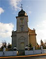
Reformed Church in Zelów

Reformed Church in Zelów

Manor house in Krzeslów

Distillery in Krzeslów

School in Pożdżenice


.jpg)


.JPG)
,_pocz._XIX_w,_Po%C5%BCd%C5%BCenice.JPG)
traffic
The voivodeship roads DW483 and DW484 run through the municipality from north to south, the DW473 touches the northeast of the municipality. Łódź is the nearest international airport. The most important roads are the national roads DK43 and DK43 , which run through the municipality from north to south. The nearest international airport is Łódź .
The nearest long-distance station is in the city of Łask on the Łódź – Ostrów Wielkopolski – Forst (Lausitz) railway line .
Web links
Individual evidence
- ↑ population. Size and Structure by Territorial Division. As of June 30, 2019. Główny Urząd Statystyczny (GUS) (PDF files; 0.99 MiB), accessed December 24, 2019 .
- ↑ a b regioset.pl: data on the municipality (Polish, accessed March 30, 2020)
- ↑ neuhaus.de: twin cities . (accessed on March 30, 2020)
- ^ Sołectwa . (Polish, accessed March 30, 2020)
- ↑ Granice okręgów wyborczych . (accessed on March 30, 2019)
- ↑ Rada Miejska w Zelowie . (accessed on March 30, 2019)
- ^ NID : Informational directory of the list of monuments of the Łódź Voivodeship (as of March 31, 2016) (PDF, 500kB; Polish, accessed on March 23, 2020) p. 3.
- ↑ Registered in the list of monuments of the Łódź Voivodeship under the number 989-XV-4 on March 26, 1960.
- ↑ Registered in the list of monuments of the Łódź Voivodeship under numbers 162-IX-8 (July 7, 1946) and 58 on July 21, 1967.
- ↑ Registered in the list of monuments of the Łódź Voivodeship from October 12, 1946 to July 14, 1995.
- ↑ Registered in the list of monuments of the Łódź Voivodeship under the numbers 165-IX-11 (December 21, 1946) and 176 on May 26, 1967.
- ↑ Registered in the list of monuments of the Łódź Voivodeship under the number 436 on July 25, 1967.
- ↑ Registered in the list of monuments of the Łódź Voivodeship under number 342 on March 16, 1984.
- ↑ Registered in the list of monuments of the Łódź Voivodeship under number 376 on November 10, 1986.
- ↑ Registered in the list of monuments of the Łódź Voivodeship under numbers 62 and 442 on July 25, 1967.
- ↑ Registered in the list of monuments of the Łódź Voivodeship under the number 431 on July 21, 1967.
- ↑ Muzeum w Zelowie . (Polish, accessed March 30, 2020)