
Grave field near Dannstadt
Coordinates: 49 ° 24 ′ 22 ″ N , 8 ° 21 ′ 8 ″ E


The Gräberfeld nature reserve near Dannstadt is the smallest nature reserve in the Rhine-Palatinate district in Rhineland-Palatinate .
The 1.172 hectare area, which was placed under nature protection in 1940 , extends southeast of the local community of Dannstadt-Schauernheim . To the west of it is the A 61 , to the southwest the L 454 state road running parallel to the grave field, the L 532 to the south and the L 524 to the east.
Existence and history
Today's nature reserve (with expansion from 1982) contains 32 Celtic burial mounds , predominantly from the third stage of the Hallstatt period and the Latène period (approx. 850 BC to 350 BC), overgrown with rare vegetation. In 1914, in contrast to today, the core area was still almost completely free of trees and shrubs.
Around 1825 there were around 200 burial mounds in the local field markings, today around 140 or remnants of them.
As early as 1910, the Palatinate District Committee for Nature Conservation leased a number of grave sites to protect them from destruction and soil erosion. This was necessary because the earth from the burial mounds was used by the surrounding farmers to fill in wet areas and improve the soil in the fields.
In 1912, the then German Consul General in Geneva , Dr. August Ludowici (1866–1945), who came from Ludwigshafen am Rhein , donated the sum of 5700 marks to purchase the property. On June 19, 1913, the former district of Ludwigshafen acquired the southern part of what is now the entire area, "in order to preserve the mixture of Pontic and Mediterranean floral elements that still existed there as the last remnant of the former heather meadows of the Vorderpfalz from destruction" . This also secured the historical graves.
On April 16, 1940, the part (southern core area) of the Dannstadt cemetery that was already part of the district at that time was declared a nature reserve. In 1982 this was expanded by 5.9 hectares of the same area.
In the municipal coat of arms of Dannstadt-Schauernheim and in the coat of arms of the community of Dannstadt-Schauernheim , the red Adonis rose symbolizes the nature reserve Gräberfeld. An Aussiedlerhof not far from the site bears the name "Adonisröschenhof" .

Official notice board

Memorial stone for the founder, Consul August Ludowici
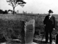
The founder, Consul August Ludowici (1866–1945), with his memorial stone, 1914

Barrow in the Dannstadt burial ground

View into the Dannstadt burial ground, from the west


See also
literature
- 100 years of active nature protection in the district: Purchase keeps grave field alive , article in: Kreiskurier des Rhein-Pfalz-Kreis , No. 3, 2010; (PDF view)
- Heinz-Josef Engels: The Hallstatt and Latène culture in the Palatinate , publishing house of the Palatinate Society for the Promotion of Science, 1967, p. 18, 31 and 34; (Detail scans)
Web links
- Website of the responsible district administration with a description of the burial site
- Grave field near Dannstadt (map) on protectedplanet.net
- Grave field near Dannstadt (extension) (map) on protectedplanet.net
- 338-011 Ordinance of the District President in Speyer of April 16, 1940 on the nature reserve "Gräberfeld bei Dannstadt" in the Dannstadt district, District District Administrator Ludwigshafen am Rhein (PDF) on naturschutz.rlp.de
- 338-042 Ordinance on the nature reserve "Gräberfeld bei Dannstadt (extension)" Ludwigshafen am Rhein district of October 19, 1982 (PDF) on naturschutz.rlp.de
Individual evidence

Bobenheimer Altrhein | Böhler Bruch-Kandelwiese | Böllenwörth | Flotzgrün | Grave field near Dannstadt | Grave field near Dannstadt (extension) | Haderwiese | Rear Roxheimer Altrhein | Horror Island | In the Wörth | Kistnerweiher | Cabbage pool skewer pool | Feudal break | Mechtersheim clay pits | New Wiese-Wasserlacher Hecke | Neuhofen Old Rhine | Neuhofener Altrhein (northern extension) | Neuhofener Woog | Ox pool | Prince Karl Wörth | Sand pit near Schauernheim | Sheep meadows | Black Forest | Spurs | Vorderer Roxheimer Altrhein Krumbeeräcker | Woogwiesen