Hill
| Hill | ||
|---|---|---|
|
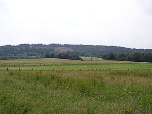
The hill with forest areas overturned by Hurricane Kyrill |
||
| height | 225.6 m above sea level NHN | |
| location | near Hasbergen , Osnabrück district , Lower Saxony ( Germany ) | |
| Coordinates | 52 ° 13 '24 " N , 7 ° 58' 9" E | |
|
|
||
| particularities | Part of the Ibbenbüren coal field and the Osnabrück hill country | |
The hill is 225.6 m above sea level. NHN high, around 5 km long and 1 km wide ridge near Hasbergen in the Lower Saxony district of Osnabrück and the third highest elevation in the Osnabrück hill country . The Upper Carboniferous Eruption is part of the Ibbenbüren hard coal field .
geography
location
The hill lies in the nature and geopark TERRA.vita (formerly: Nature Park Nördlicher Teutoburger Wald-Wiehengebirge ) between the nearby Teutoburg Forest in the south and the somewhat distant Wiehengebirge in the north. It is located about 7.5 km south-southwest of Osnabrück as part of the Osnabrücker Bergland in the urban area of Georgsmarienhütte and in the municipal areas of Hagen am Teutoburg Forest and Hasbergen , the latter having the largest part of the mountain range.
The hill is around 5 km long and around 1 km wide in the area of its highest point, the hill of the same name; in the context of its northern and southern foothills, however, it is much wider. The hill area also includes the Rote Berg in Hasbergen.
Surveys
The elevations and their foothills of the hill include - sorted by height in meters (m) above sea level (NHN):
|
|
geology

In addition to the carbon nests of the Ibbenbürener Bergplatte near Ibbenbüren and the Piesberg , the hill emerges as the third elevation of the Oberkarbon . It is covered by Zechstein in the north . In the south there are complicated fault structures with throw heights of 1000 m. The mineralization of the limestone of the lower Zechstein Age (Zechsteinkalk) was carried out by hydrothermal solutions . The ore deposit is 8 to 10 m thick throughout and is covered by the said lime. Analyzes showed that the weathered brown iron stone contains 36.9 to 42.3 percent by weight iron, and the spate iron stone contains 31.8 to 35.9 percent by weight iron. The lime has from 7.3 to 14.9% by weight of iron and up to 2% by weight of manganese.
Accumulations of zinc and lead ores occur only to a minor extent and carry silver with them. There are plants that are bound to the increased heavy metal content.
The emergence of hydrothermal solutions is seen in connection with the Bramscher Pluton .
Historical mining of silver-containing non-ferrous metals
As early as 1180, a “Silverkuhle” was subject to the Dompropst Osnabrück.
In 1722, Prince-Bishop Ernst August II resumed prospecting for silver ore. Bergschreiber Paxmann from Zellerfeld examined the ore samples, which contained 65 pounds of lead and 2 lots of silver per hundredweight . Osnabrück coins were minted from the hill silver obtained.
Outcrops in the fields of Aaron, Crown Prince and Emma
In the middle of the 19th century, the mining of non-ferrous metal ores revived. In 1860 the fields of Aaron and Crown Prince were consolidated and transferred to the newly founded "Osnabrücker Zinkgesellschaft". A tunnel intended for extraction and water removal was excavated on the Red Mountain in 1867. The 56 m long tunnel was accessed through five shafts from 5 to 22 m deep. The zinc content of the bearing was 27.5% by weight. The company was stopped in 1873 after 12 to 14 workers in the Aaron colliery and 308 t in the Kronprinz colliery.
Iron ore mining
Legends of the hill smith and the forging hill dwarves suggest that ore was extracted in the hill area very early. This is confirmed by numerous pings on the slopes of the hill.
Ore extraction by the Beckeroder ironworks
From 1852 the Beckeroder ironworks extracted iron ore in the Hüggel I mine field . With the purchase of the Beckeroder Hütte by the Georgs-Marien-Bergwerks- und Hüttenverein in 1856, this mine field came into the possession of the Hüttenverein.
Ore extraction by the Georgs-Marien-Bergwerks- und Hüttenverein

At the time of the purchase by the Georgs-Marien-Bergwerks- und Hüttenverein, two small pits were already in operation. The Hermine opencast mine and the Hedwig underground mine . The Hüggelbahn was built in 1865 to transport the ores to the ironworks in Georgsmarienhütte more cheaply . The ore extraction increased from 86,000 t in 1863 to 133,000 t in 1872. The pit water was diverted through the Mathilde gallery built in 1868. In 1870, the focus was on civil engineering, a civil engineering floor was created 20 m below the tunnel floor. A central dewatering has been in operation in the Augustaschacht since 1876. Ore mining reached its peak in the 1870s. The peak values were reached in 1873 with 235,882 t ore extracted and in 1877 with 584 workers. With the purchase of the Ibbenbürener ore mines , the workforce and the production on the hill decreased. During the First World War, 200 men and 57 prisoners of war were employed in the pits. In 1931 with the completion of civil engineering, 166 men were still mining 18,000 tons of ore. Only in the Second World War were ores mined again in civil engineering.
Lime mining
Ferrous aggregate lime was mined during the period of iron ore mining and beyond. A cable car built in 1928 was used until 1937 to transport limestone from the “Silbersee” quarry to the Hüggelbahn. After the cessation of lime extraction directly on the hill at the beginning of the 1930s, a 6.34 km long cable car built in 1937 was used until 1967 to descend lime from the Holperdorp ( Lienen ) limestone quarry on the Lienener Berg in the Teutoburg Forest via the unloading station near the Augustaschacht with the hill railway . The lime was used in the blast furnaces and in the cement works of the Georgs-Marien-Bergwerks- und Hüttenverein. Around 10 million tons of iron ore and iron-bearing aggregate lime were extracted during the entire mining period.
Hard coal deposit
Proof of hard coal seams on the Hüggel was provided by a 675 m deep borehole in the Mathildaschacht. Nine seams of small thickness were verified. Seams 6 to 9 had a total thickness of 2.35 m of pure coal. Plans to build a mine failed. In the time of need after the First World War , the plan was taken up again and sunk the 299.12 m deep Südhüggelschacht. However, there was no mining due to the small seam thickness.
Witnesses

The Augustaschacht Ohrbeck, set up as a memorial, and the Silbersee as the remainder of the lime mining have been preserved to this day . The route of the former Hüggelbahn can still be seen . After the tracks were dismantled, it has now been converted into hiking trails. There is also a geological nature trail in the Hüggel with two tours of different lengths. The still existing pits of the iron ore mine are also witnesses. In addition, some remains of the wall, e.g. from crushing plants, have been preserved. Nature has now recaptured the pits. They are overgrown with trees and bushes.
Legends
The hill is a place of sagas and legends . There is the legend of the hillsmith who ruled over the mountain spirits who mined for gold and silver. In the stories of the well is Sgönaunken (dwarves) the speech that the so-called Wüllekeslöckern lived and similar to brownies have done to people in the area of Hüggels much good.
See also
Individual evidence
- ↑ a b c Map services of the Federal Agency for Nature Conservation ( information )
- ↑ a b Der Hüggel - old mining in the Teutoburg Forest , information and photos of preserved tunnels, on 7grad.org
- ^ Hasbergen - Tecklenburger family research. In: te-gen.de. Retrieved January 6, 2018 .
literature
- Friedrich Stockfleth: The iron ore deposits on the hill near Osnabrück - A geological and mining study , Bädeker, Essen 1895
- Hiking map (1: 25,000): Georgsmarienhütte, Hagen aTW, Hasbergen . City of Georgsmarienhütte, municipality of Hagen aTW, municipality of Hasbergen (ed.), Lamkemeyer Druck, Georgsmarienhütte 2006
- Heinrich Borchelt, Heinrich Göers (revised by Willi Jacob): Local history for the schools in the city of Osnabrück and the district of Osnabrück . Meinders & Elstermann, Osnabrück 1958
Web links
- The Hüggel - old mining in the Teutoburg Forest , information and photos of preserved tunnels, on 7grad.org
- Silbersee and tunnels in the hill , on geopark-terravita.de


