
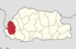
Haa (district)
| Haa district | |
|---|---|
  |
|
| Basic data | |
| Country | Bhutan |
| Capital | Haa |
| surface | 1899 km² |
| Residents | 12,963 (2012) |
| density | 6.8 inhabitants per km² |
| ISO 3166-2 | BT-13 |
 |
|
Coordinates: 27 ° 18 ' N , 89 ° 12' E
Haa ( ཧཱ་ རྫོང་ ཁག་ ; also: Ha) is one of the 20 districts ( dzongkhag ) of Bhutan . About 13,499 people live in this district (2012). The Haa area covers 1899 km². Haa lies at an altitude between 1000 and 5600 m.
The capital of the district is of the same name Haa .
The Haa district is divided into 6 Gewogs :
Web links
Commons : Haa District - Collection of images, videos and audio files

Bumthang | Chukha | Dagana | Gasa | Haa | Lhuntse | Mongar | Paro | Pemagatshel | Punakha | Samdrup Jongkhar | Velvet | Sarpang | Thimphu | Trashigang | Trashiyangtse | Trongsa | Tsirang | Wangdue Phodrang | Zhemgang