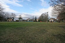
Habřinka
| Habřinka | ||||
|---|---|---|---|---|
|
||||
| Basic data | ||||
| State : |
|
|||
| Region : | Pardubický kraj | |||
| District : | Pardubice | |||
| Municipality : | Bukovka | |||
| Geographic location : | 50 ° 6 ' N , 15 ° 38' E | |||
| Height: | 238 m nm | |||
| Residents : | 126 (March 1, 2001) | |||
| Postal code : | 533 41 | |||
| License plate : | E. | |||
| traffic | ||||
| Street: | Bukovka - Křičeň | |||
Habřinka (German Habrinka , 1939–45: Hag ) is a district of the municipality Bukovka in Okres Pardubice in the Czech Republic . It is located five kilometers northwest of Lázně Bohdaneč .
geography
Habřinka is located in the Středolabské tabule (table land on the middle Elbe ). In the northeast rises the Oškohrb (259 m nm). In the forest south of the village there is a pond area with the ponds Skřin, Rozhrna, Horní Jílovky and Dolní Jílovky, to the south-east there is another extensive pond area protected as a nature reserve with the Bohdanečský rybník ( Bohdanetsch pond ) and the Matka.
Neighboring towns are Pravy and Kuklínky in the north, Rohoznice and Křičeň in the Northeast, Dolany , Bouda u Dolan and Stéblová the east, Mlýny, SPA Bohdaneč and Novinsko the southeast, Neratov in the south, Prelovice and Bukovka in the southwest, Rohovládova Bělá in the west and Kasalice in Northwest.
history
The village was laid out as a Rundling . Habřinka belonged to the possessions of the Opatowitz Benedictine monastery , which was destroyed in 1421 during the Hussite Wars . In 1437 King Sigismund the Bukůvký of Bukůvka sold it , who attached it to their Bukovka estate. Later the Bukovský von Hustiřan owned the Bukovka estate. After the death of Bavor von Hustiřan, his heirs sold the fortress Bukovka with the villages Bukovka, Habřinka and Bělá , the desert fortress Jílovka in the pond Skřin and the desert village Mokrý for 2500 shock groschen to Wilhelm von Pernstein . In 1535 Johann von Pernstein sold the corridors of the desert fortress Jílovka to the town of Bohdaneč. When Jaroslav von Pernstein sold the Kunburg reign to King Ferdinand I in 1560 , Habřinka was one of their estates.
In 1835, the in consisted Chrudim District village located Habřinka of 10 houses, in which 79 people, including three Helvetic families lived. The place was under the municipal courts of Bukowka . The Catholic parish was Biela , the Protestant parish was in Bukowka. Until the middle of the 19th century, Habřinka remained subordinate to the Imperial and Royal Chamber of Commerce Pardubice.
After the abolition of patrimonial Habřínka formed from 1849 a district of the municipality Bukovka in the judicial district of Přelauč . From 1868 the village belonged to the Pardubice district . Habřinka has been used as an official place name since the end of the 19th century . In 1900 there were 137 people living in Habřinka's 25 houses. In 1949 Habřinka was assigned to the Okres Přelouč; this was repealed in the course of the territorial reform of 1960, since then the village has belonged to Okres Pardubice. On March 3, 1991 the place had 114 inhabitants; at the 2001 census, there were 126 people in Habřinka's 42 houses.
Community structure
Habřinka is part of the Bukovka cadastral district.
Attractions
- Cross with a stone base in the village square
- Bell tower in the village square
Web links
Individual evidence
- ^ Johann Gottfried Sommer , Franz Xaver Maximilian Zippe: The Kingdom of Böhmen. Statistically and topographically presented, vol. 5 Chrudimer Kreis , Prague 1837, p. 62
- ↑ https://www.czso.cz/documents/10180/20565661/13810901.pdf/3fde2441-c81b-4a1e-9b94-551e65007f70?version=1.0
- ↑ http://www.uir.cz/casti-obce/410454/Habrinka


