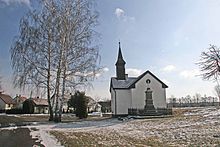
Stéblová
| Stéblová | ||||
|---|---|---|---|---|
|
||||
| Basic data | ||||
| State : |
|
|||
| Region : | Pardubický kraj | |||
| District : | Pardubice | |||
| Area : | 783.6105 ha | |||
| Geographic location : | 50 ° 6 ' N , 15 ° 45' E | |||
| Height: | 223 m nm | |||
| Residents : | 242 (Jan. 1, 2019) | |||
| Postal code : | 533 45 | |||
| License plate : | E. | |||
| traffic | ||||
| Street: | Opatovice nad Labem - Pardubice | |||
| Railway connection: | Pardubice – Liberec | |||
| structure | ||||
| Status: | local community | |||
| Districts: | 1 | |||
| administration | ||||
| Mayor : | Vladimír Exner (as of 2017) | |||
| Address: | Stéblová 12 533 45 Opatovice nad Labem |
|||
| Municipality number: | 572934 | |||
| Website : | www.steblova.cz | |||
Stéblová ( German Steblowa ) is a municipality in the Okres Pardubice in the Czech Republic . It is located seven kilometers north of the city center of Pardubice .
geography
Stéblová is located on the right side of the Velká strouha trench in the Pardubická kotlina ( Pardubice Basin ). To the north-west of the village there is an extensive pond area with the three Oplatíl ponds and the Hrádek pond. In the southwest rises the ridge Stéblovská stráň (233 m nm). The Pardubice – Liberec railway runs east of the village, with the Silnice I / 37 behind it . The Stéblová train station is located one and a half kilometers northeast of the village.
Neighboring towns are Nové Ždánice, Ždánický Dvůr, Podůlšany Mala Čeperka and Čeperka in the north, Hrobice and Dříteč in the Northeast, Němčice the east, Srch and Staré Hradiště in the southeast, Ohrazenice, Doubravice and Pohránov in the south, Hradek, Boudy and Bohdaneč Spa in the southwest , Bukovka and Habřinka in the west and Dolany and Plch in the northwest.
history
Stéblová belonged to the possessions of the Opatowitz Benedictine monastery . The village was first mentioned in writing in 1385, when part of its proceeds were attributed to the Heiliggeist Church in Königgrätz . After the monastery was destroyed during the Hussite Wars in 1421, King Sigismund Stéblová, together with other former monastery villages, signed a pledge to Diviš Bořek von Miletínek , who formed the Kunburg domain . Wilhelm von Pernstein , who had acquired the dominions of Kunburg and Pardubitz in 1491, had the Opatowitz Canal dug between 1498 and 1521 to feed the Elbe water into the Pardubitz fish ponds. In the 1540s, the two large fish ponds Oplatíl and Velká Čeperka were created between Ždánice , Srch and Čeperka on the canal. The villages of Stéblová, Velké Kavčiny, Malé Kavčiny and Černá pod Čeperkou were flooded with the Oplatíl.
Since most of the fields of Stéblová remained outside the pond, Johann von Pernstein's sons had the village rebuilt in 1549 below the southeast side embankment of the Oplatíl. At that time, Stéblová consisted of two farmers and seven cottagers. 1560 sold Jaroslav of Pernstein dominion Kunburg to King Ferdinand I .
In 1835 the village of Steblowa , located in the Chrudim district , consisted of 26 houses in which 194 people, including one Protestant family, lived. Steblowa belonged to the district of the Wositz pastor and was parish of the local church in Zdanitz . Until the middle of the 19th century, Steblowa remained subordinate to the Imperial and Royal Chamber of Commerce Pardubitz.
After the abolition of patrimonial Stéblová formed from 1849 a municipality in the judicial district of Pardubice . Between 1856 and 1857, the south-north German connecting line built the railway between Pardubitz and Josefstadt , which crossed the Velká Čeperka pond on a dam. From 1868 the community belonged to the Pardubitz district . At the end of the 19th century, the districts Na Oplatile, U Nádraží and Ždánický Dvůr belonged to Stéblová. In 1900 the village consisted of 31 houses, in 1930 there were 40. In 1949 Stéblová was assigned to the Okres Pardubice-okolí; this was lifted in the course of the territorial reform of 1960, since then the village has belonged to Okres Pardubice. On November 14, 1960, two passenger trains collided south of Stéblová; the railway accident in Stéblová, with 118 dead and 110 injured, is considered to be the worst train accident in Czechoslovakia . 1976 Stéblová was incorporated into Srch. On November 24, 1990, Stéblová broke away from Srch and formed its own community.
Community structure
No districts are shown for the municipality of Stéblová. The single-layer Boudy ( Bauda ) belongs to Stéblová .
Attractions
- Sandstone cross at the southern end of the village square, erected in 1899 on the occasion of the 50th anniversary of the throne of Emperor Franz Joseph I instead of a wooden cross. It is surrounded by a cast iron bridle
- Syringe house with bell tower, built in the first half of the 20th century
- Memorial stone to the railway accident of 1960 , south of the village. It is located 80 m from the scene of the accident and was erected by the municipality in 2000 in place of a damaged cross.
- The Hrádek quarry pond, west of the village, arose from gravel mining on the Oplatíl fish pond and is used as bathing water and for drinking water for the town of Pardubice.
Web links
Individual evidence
- ↑ uir.cz
- ↑ Český statistický úřad - The population of the Czech municipalities as of January 1, 2019 (PDF; 7.4 MiB)
- ^ Johann Gottfried Sommer , Franz Xaver Maximilian Zippe: The Kingdom of Böhmen. Represented statistically and topographically. Volume 5: Chrudimer Kreis. Prague 1837, p. 68.


