
Port of Ludwigshafen on the Rhine
| Port of Ludwigshafen on the Rhine | |||
|---|---|---|---|
| Data | |||
| UN / LOCODE | DE LWR | ||
| operator | Hafenbetriebe Ludwigshafen am Rhein GmbH, BASF and others | ||
| opening | 1823 | ||
| Port type | Ports and Lands | ||
| Throughput | 6.9 million tons (2016) | ||
| website | http://www.haefen-rlp.de/hafen-ludwigshafen.html | ||
| Geographic information | |||
| place | Ludwigshafen | ||
| country | Rhineland-Palatinate | ||
| Country | Germany | ||
 |
|||
| Coordinates | 49 ° 30 '47 " N , 8 ° 25' 48" E | ||
|
|||

The port of Ludwigshafen am Rhein is one of the largest and most efficient public ports on the Upper Rhine in Rhineland-Palatinate . It covers an area of over 150 hectares, spread over several locations within Ludwigshafen, and handled 6.9 million tons of goods on the water side in 2016.
geography
The port in Ludwigshafen am Rhein is located on the eastern edge of the city at Rhine kilometers 419 to 432 L at an altitude of 90 to 95 m above sea level. NHN . There are several parts or pools; these are in the direction of flow (from south to north):
- Rhine km 418.9 L: Kiefweiher marina
- Rhine-km 420.8 L: Roadstead Süd (RTG- Lände )
- Rhine km 421.4 L: Kaiserwörthhafen in the Mundenheim district
- Rhine-km 421.4 L: Ölhafen (also Mundenheimer Altrheinhafen )
- Rhine km 423.8 L: Luitpoldhafen in the southern part of the city
- Rhine-km 425.1 L: winter harbor ( removed )
- Rhine-km 425.7 L: Roads North (Zollhafen) ( Stromhafen )
- Rhine-km 431.9 L: North port
history

Like the city itself, the Ludwigshafen harbor developed from the Mannheim Rheinschanze . This was expanded into an unloading and loading area in 1823 and into a winter harbor in 1847 and was called Ludwigshafen from 1843. In 1898 the port was expanded to include the Luitpoldhafen, followed by the Mundenheim port in 1902 and the Kaiserwörth port in 1918.

During the Second World War , the port was largely destroyed in 1943–1945. In the 1950s, the port was rebuilt and the winter port basin was filled in due to space requirements. After a fire accident in 1976, a separate port, the Landeshafen Nord, was built for and with BASF for hazardous substances . In the 1980s, this was followed by expansion into a modern container port, initially in Luitpoldhafen and with the completion of a new, more efficient container terminal at the southern Kaiserwörthhafen. At the beginning of the millennium, the Zollhofhafen near the city center was given up. In its place, with an investment volume of 220 million euros, a new city quarter with a 30,000 square meter shopping center and restaurants have been created. A hotel and the renovation of a currently fallow shipyard hall is to take place in a further expansion step. The project was realized by the Hamburg investor ECE , who also operates the shopping center.
On October 17, 2016, at 11:30 a.m. on the southern pier of the northern state port, an explosion and a major fire occurred on the BASF site .
Locations
The Ludwigshafen Rheinhafen is the fifth most powerful inland port in Germany . Together with the neighboring Mannheim port , with which there has been a cooperation since 2001, it forms the second largest inland port in Germany. With BASF, the Rheinhafen is developing the largest chemical company in the world and is therefore of outstanding importance in the Rhine-Neckar metropolitan region .
The port area covers 120 hectares and more than 14 km of quays . The infrastructure is a container bridge with 62 t and another for rail loading with 52 t load capacity. There are also nine crane systems up to 25 t, a 104 t mobile crane, three belt conveyor systems with pouring pipes as well as 19 pumps for liquid goods and various floor conveyors and a heavy goods transshipment point . In the adjacent industrial areas there are 39 hectares of open-air storage space, 3.8 hectares of indoor storage, grain storage silos for 31,000 t and 140,000 m³ of tank storage space .
Roads south
This river port stretches for almost 1.5 km on the left bank of the Rhine. The transhipment facilities were built during the First World War and completely destroyed in the Second World War. The current structure dates from the 1970s. Mainly construction materials and fuels are handled there . The infrastructure includes a 200 m paved quay, two jetties on sloping banks, a portal crane, pumps, conveyor belts and a rail connection.
Kaiserwörthhafen
The Kaiserwörthhafen was built from 1912 to 1918 as a supplement to the Mundenheimer Hafen (oil port). Initially mainly coal and armaments were handled there. There were 1.5 km of quays at the Stromhafen and an inland basin 850 m long and 90 m wide. During the Second World War, the facilities were almost completely destroyed by bombing in 1943–1945 . The area was already selected as a target for a possible atomic bomb because of the dense settlement of so-called war - important industry and infrastructure . However, it was occupied by Allied troops in March 1945 , before the first nuclear weapon test was successfully carried out in July 1945 . The reconstruction took place from 1951 to 1969 in several stages. The container terminal in Kaiserwörthhafen was opened in October 2004 .
Oil port
The Mundenheim old Rhine arm was expanded into a protective harbor with 1.8 km of quays in 1898/1899. From 1911 to 1915 the basin was widened and rededicated as an oil port.

Luitpoldhafen
The Luitpoldhafen was built from 1893 to 1898. The northern part of the 2.5 km quay has 1250 m of quay walls, the southern part is predominantly sloped. It was separated from the Rhine stream by chamber locks . Around 1900 a level clock was added to the Nordschleuse . The lock was shut down in the 1960s, the lock gate and the associated swing bridge dismantled in 1967 and a dam was raised there. The level clock has been preserved and is a listed building. Today the Ludwigshafen Canoe Club is based there. WSP also has the Ludwigshafen station in Luitpoldhafen and its own quay on the south bank. In 1989 the Luitpoldhafen received a container loading bridge, which today, like parts of the port railway , has been dismantled. The rail connection only opens up the quay facilities as far as the Rheinpfalz Police Headquarters on the north bank with a pull-out track. A semi-portal crane is also available there. The southern Luitpoldhafen, the so-called Parkinsel , has been in a state of upheaval since 2005 ; modern housing predominates.
Winter harbor (departed)
The winter harbor was from 1844 to 1847 in 1824 caused by floods Kolk built. It was also connected to the Palatinate Ludwig Railway in 1847 . In 1864/1865 it was expanded again. He acted u. a. as a berth for the ships of the Bavarian-Palatinate Steam-Schlepp-Schifffahrts-Gesellschaft . During the First World War and with the emergence of the Kaiserwörth port, its importance declined. After being damaged in World War II, it was abandoned and completely filled in from 1954 to 1956. A new district was built there in the 1960s.
Roads North (former customs port)
The former embankment roadstead was expanded from 1874 to 1880 with a permanent quay wall to become a customs port. There has been no transshipment at Reede Nord since 2004; In the years that followed, a new city district with restaurants, shopping and leisure opportunities was built there.
North port
The North Port was opened in 1976. It covers 14 hectares of water. Seven of the planned twelve berths have currently been expanded and have a total of 23 loading arms for liquids. They are connected via pipelines to the neighboring BASF plant , which, as the main user of the port, finances, maintains and operates the facilities. If necessary, cargo can be unloaded from the free berths with mobile cranes . Although the port railway passes directly to the south, it does not directly access the quays . The transshipment points are each equipped with their own fire extinguishing system and two foam cannons. In addition, there is a compressed air oil barrier at the port entrance and a visual monitoring system with ten remote-controlled cameras that is manned around the clock. Seven ships are handled there on average every day. The throughput volume is around 2.8 million tons annually.
Port railway
The port railway has existed since 1847 with the connection to the Palatinate Ludwig Railway. Today the track systems cover a network of more than 14 km.
traffic
The ports in Ludwigshafen are accessible via local roads to the federal highway 9 , the federal highway 6 and the federal highway 61 . The rail traffic of the port railway is connected to the Mannheim – Saarbrücken railway line .
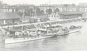
Harbor view 1884
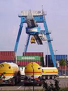
Container bridge in the Kaiserwörthhafen
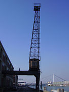
Harbor crane in the Rhine harbor

Gauge clock at Luitpoldhafen, on the left the former lock entrance
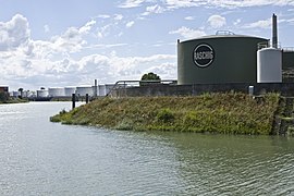
left Mundenheimer Altrheinhafen

Harbor panorama 2008
_001.jpg)


Web links
- Website of the Ludwigshafen Rhine port
- Website of the Mannheim-Ludwigshafen port cooperation
- Canoe club website
- Motor Yacht Club website
- former winter harbor, aerial photo from 1930
- Major fire at Landeshafen 2016, aerial video on Youtube (0:30), approach and view from the north
Individual evidence
- ^ Mannheim and Ludwigshafen stable . In: Daily port report of January 31, 2017, p. 13
- ^ Chronicle of the ports in Ludwigshafen
- ↑ Press report on the major fire at the North Harbor
- ^ Port partnership, Ludwigshafen infrastructure
- ↑ Infrastructure of the ports of Ludwigshafen ( Memento of the original from November 23, 2015 in the Internet Archive ) Info: The archive link was inserted automatically and has not yet been checked. Please check the original and archive link according to the instructions and then remove this notice.
- ^ History of the ports of Ludwigshafen
- ↑ Chamber lock, level clock
- ↑ Luitpoldhafe ( Memento of the original from November 23, 2015 in the Internet Archive ) Info: The archive link was inserted automatically and has not yet been checked. Please check the original and archive link according to the instructions and then remove this notice.
- ↑ Housing development at Luitpoldhafen (.pdf) ( Memento of the original from November 23, 2015 in the Internet Archive ) Info: The archive link was inserted automatically and has not yet been checked. Please check the original and archive link according to the instructions and then remove this notice.
- ↑ former winter harbor ( memento of the original from November 23, 2015 in the Internet Archive ) Info: The archive link has been inserted automatically and has not yet been checked. Please check the original and archive link according to the instructions and then remove this notice.
- ↑ old customs port
- ↑ Press report port anniversary Landeshafen North
- ↑ a b c d North port
- ↑ Landeshafen North in BASF webpage
- ^ Ludwigshafen port railway