
Handorf (Peine)
|
Handorf
City of Peine
|
||
|---|---|---|
 |
||
| Height : | 70 m | |
| Residents : | 886 (Nov. 30, 2012) | |
| Incorporation : | July 1, 1968 | |
| Postal code : | 31226 | |
| Area code : | 05171 | |
Location of Handorf in Lower Saxony |
||

Handorf is a village and southern district of the city of Peine in the Peine district in Lower Saxony .
geography
The place is located in the middle of several gravel ponds between the B 65 and the B 444 . The Fuhse runs to the east .
Handorf is in the northernmost part of the Hildesheimer Börde . Directly south of the Mittelland Canal. This is the transition from the heavy, good soils of the north of the Peiner Südkreis to the sandy, less productive soils of the Peiner Nordkreis.
In the west and northwest of the village is the Handorf Lake District. Part of the Fuhseniederung landscape protection area stretches from the Fuhse over four pieces of forest: Adjacent to the lake plateau is the Handorf wood in the southwest of the village, which merges into the Bülten wood. Heers and Heistern are to the west of the lake district. In the flooded area of the Fuhse, the Beeke runs south-east of Handorf on the left along the Fuhse and then flows into it.
The lake district was recorded as a valuable area for guest birds , and on the Fuhse valuable areas for breeding birds . Parts of Heistern and Heers as well as a bank area of the large gravel pond in the west were included in the state-wide biotope mapping, as there are, among other things, use-related mixed oak forests on sites of mesophilic beech forests with less calcareous soils or wet bushes of narrow-leaved pastures in floodplains and nutrient-rich fens or swamps .
history
The place is first mentioned in 1146 as "Hattendorp", later it was also called "Haddendorp". Handorf became an independent parish in 1302.
Handorf became part of the city of Peine on July 1st, 1968.
politics
After Annika Katschinski (SPD) resigned in May 2017, Udo Fiesel (SPD) is the acting local mayor.
coat of arms
The coat of arms shows a golden disc with ornaments on a red shield above a golden wavy band in the base of the shield. The disc indicates a corresponding find of Bronze Age belt jewelry plates on site, which belonged to a hoard from around three and a half thousand years ago. The golden wavy line symbolizes the nearby feet. The colors red and gold illustrate the centuries-long membership in the duchy of Hildesheim .
The coat of arms was approved by the Interior Minister of Lower Saxony on October 16, 1951; the design was made by Rudolf Dehnke.
Culture and sights
- South of the village is the Dutch windmill , built in 1864 , which today - without its blades - is no longer in operation.
- In the north of the village stands the parish church, the parish separated from the church in Berkum in 1302 .

St Mary's Church

Town view
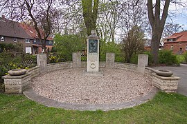
War memorial
_IMG_4867.jpg)
_IMG_4874.jpg)
_IMG_4869.jpg)
Economy and Infrastructure
In the Handorf district, wheat, barley, maize and beets are primarily grown. Intensive grazing can also be carried out in parallel. Whereby the pasture soils in the Fuhseniederung east of the village are sometimes too wet on some weeks of the year. In the dry season, however, a high-yield hay / silage harvest can be brought in here without using a lot of fertilizer.
The structure of around six smaller and larger gravel ponds, some of which have been renatured for a long time, is a fishing and surfing area, which is also often used for local recreation.
Web links
- Handorf on peine01.de
- Handorf - A historical view on peine01.de
Individual evidence
- ↑ Lower Saxony environmental maps on Umweltkarten-niedersachsen.de
- ^ Peiner Allgemeine Zeitung, Peine, Lower Saxony ,: Handorf mayoress - anonymous threatening letter: Annika Katschinski resigns -. In: paz-online.de. May 12, 2017. Retrieved May 14, 2017 .
- ^ Arnold Rabbow: New Braunschweigisches Wappenbuch. Braunschweiger Zeitungsverlag, Meyer Verlag, Braunschweig 2003, ISBN 3-926701-59-5 , p. 128.

Berkum | Dungelbeck | Duttenstedt | Eixe | Essinghausen | Handorf | Peine | Tube | Rosenthal | Schmedenstedt | Schwicheldt | Stederdorf | Vöhrum | Wendesse | Woltorf