
Schwicheldt
|
Schwicheldt
City of Peine
|
||
|---|---|---|
 |
||
| Height : | 86 m | |
| Residents : | 1318 (December 31, 2017) | |
| Incorporation : | March 1, 1974 | |
| Postal code : | 31226 | |
| Area code : | 05171 | |
Location of Schwicheldt in Lower Saxony |
||

Schwicheldt is a village and western district of the city of Peine in the Peine district in Lower Saxony . The place borders on the northern edge of the Mittelland Canal and is crossed by the federal highway 65 .
history
The place is first mentioned in 1131 as "Shvegelten", later "Sueglete", "Suechlete" and "Sulglete", also "Schwicholt". Schwicheldt became an independent parish in 1185 and the priest Eckerhardus in 1215.
Around 1550, the then owner of Schwicheldt, Christoph von Oberg , built the Giesenburg in Feldmark.
With the regional reform , which came into force on March 1, 1974, Schwicheldt became a district of the city of Peine.
politics
The local mayor is Christian Bartscht (CDU).
coat of arms
The coat of arms shows on a golden shield a red flower with two leaves from which in the middle of a calyx blossom and on the sides two rose blossoms with golden clusters. The flower stands on a red six-spoke wheel and symbolizes a flower of life . In rural folk art, the wheel is also a symbol of life and in this case represents a wheel of the year with six double months. The depiction on the coat of arms is based on the carvings on the door pillar of a farmhouse from 1856. The colors red and gold are reminiscent of belonging to the former duchy of Hildesheim .
The coat of arms was confirmed on January 19, 1952 by the district president in Hildesheim, the design comes from Rudolf Dehnke.
Culture and sights
- The manor in the center of the village was the eponymous seat of the von Schwicheldt family . The ownership later passed to the von Oberg family until 1843 . The Counts of Schwicheldt on Söder then bought it back and passed it on to the Counts of Hardenberg , who are still based there today, after they had died out in the male line in the 20th century .
- The Schwicheldt water tower with a height of around 20 m is now a listed building . It was built by the Reich Waterways Administration as a water supply system for the community because the construction of the Mittelland Canal lowered the groundwater.
- The neo-Gothic church from 1843 still contains parts of the original structure from 1185 in the lower area.

Church from 1843
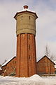
Water tower
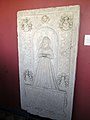
Epitaph of Elisabeta von Schwicholt († May 2, 1568) in the Imperial Palatinate of Goslar
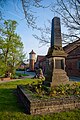
War memorial and water tower in the town center

Half-timbered gatehouse of the manor from 1782

Mittelland Canal near Schwicheldt

The preserved half-timbered houses have elements on the house beam that can be found in today's coat of arms.
_IMG_5117.jpg)
_IMG_5115.jpg)


Neighboring places
traffic

In terms of traffic, Schwicheldt is connected to the federal road 65 running south . For shipping, there is the Schwicheldt landing on the Mittelland Canal , which is operated by Agravis Raiffeisen .
Web links
Individual evidence
- ↑ Peine01.de .
- ^ Federal Statistical Office (ed.): Historical municipality directory for the Federal Republic of Germany. Name, border and key number changes in municipalities, counties and administrative districts from May 27, 1970 to December 31, 1982 . W. Kohlhammer GmbH, Stuttgart and Mainz 1983, ISBN 3-17-003263-1 , p. 217 .
- ^ The local councils of the city of Peine and their members , accessed on May 28, 2017.
- ^ Arnold Rabbow: New Braunschweigisches Wappenbuch. Braunschweiger Zeitungsverlag, Meyer Verlag, Braunschweig 2003, ISBN 3-926701-59-5 , p. 129f

Berkum | Dungelbeck | Duttenstedt | Eixe | Essinghausen | Handorf | Peine | Tube | Rosenthal | Schmedenstedt | Schwicheldt | Stederdorf | Vöhrum | Wendesse | Woltorf