
Hanila (rural community)
| Hanila | |||
|
|||
| State : |
|
||
| Circle : |
|
||
| Founded : | 1992 | ||
| Coordinates : | 58 ° 37 ' N , 23 ° 38' E | ||
| Height : | 10 m | ||
| Area : | 232 km² | ||
| Residents : | 1,373 (January 1, 2012) | ||
| Population density : | 6 inhabitants per km² | ||
| Time zone : | EET (UTC + 2) | ||
| Telephone code : | (+372) 047 | ||
| Postal code : | 90102 | ||
| Community type: | former rural community | ||
| Structure : | 29 villages | ||
| Postal address : | Keskuse tea 3 90102 Kõmsi |
||

|
|||


Hanila ( Hanila vald ) is a former rural community in Lääne County in the west of the Republic of Estonia . In 2017 Hanila was integrated into the rural community of Lääneranna in Pärnu County .
description
Hanila was the southernmost rural community in Lääne County. Their area was 232 km². It had 1,373 inhabitants (January 1, 2012).
A museum was opened in the village of Hanila in 1993. It deals primarily with the local textile and jewelry art from an ethnographic point of view. In addition, the historical life of the peasant society Läänemaas is presented.
nature
The Baltic Sea stretched west of the rural community . The Virtsu Ferry Terminal also belonged to Hanila . A ferry connection leads from here to the island of Muhu , which is connected by a dam to the largest Estonian island of Saaremaa . There are numerous smaller islands off the coast. Numerous boulders and small bays line the coastal landscape.
40% of the land area was covered by forest. There were numerous moors inland. Four nature reserves were designated in the rural community. The nature reserve of Puhtu-Laelatu ( Puhtu-Laelatu looduskaitseala ) was part of the Matsalu National Park .
At the end of the 18th century, District Administrator Carl Thure von Helwig (1741–1810) had a complex with summer houses built in the Chinese style on the Puhtu peninsula . There were also avenues lined with sculptures, which the patron of art and culture had created. In 1813 the world's first surviving monument to Friedrich Schiller was erected there.
Villages
In addition to the main town and administrative center Kõmsi belonged to the rural community of the villages Äila , Esivere , Hanila , Karuse , Kaseküla , Kause , Kinksi , Kiska , Kokuta , Kuke , Kõera , Linnuse , Lõo , Massu , Mõisaküla , Mäense , Nehatu , Nurmsi , Pajumaa , Pivarootsi , Rame , Rannaküla , Ridase , Salevere , Ullaste , Vatla , Virtsu and Voose .
economy
The economic center of the rural community was in the main town of Kõmsi with its wire production. In addition, the Virtsu ferry port was of great economic importance. One of the largest wind farms in the Republic of Estonia was located near Virtsu, the most populous place in the rural community .
photos

Vatla mansion

Wind farm at Virtsu

Ferry port to the island of Muhu

Laelatu Nature Reserve
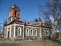
Former Orthodox Church of Uue-Virtsu


Web links
- Entry in Eesti Entsüklopeedia (online version)