Hirschau (Tübingen)
|
Hirschau
University city of Tübingen
|
|
|---|---|
| Coordinates: 48 ° 30 ′ 5 ″ N , 8 ° 59 ′ 40 ″ E | |
| Height : | 330 (330-475) m |
| Area : | 6.17 km² |
| Residents : | 3428 (Jun 30, 2010) |
| Population density : | 556 inhabitants / km² |
| Incorporation : | July 1, 1971 |
| Postal code : | 72070 |
| Area code : | 07071 |
|
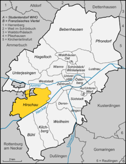
Location of Hirschau in Tübingen
|
|
|
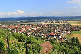
View from the Spitzberg to Hirschau
|
|
Hirschau is a district of the university town of Tübingen in the state of Baden-Württemberg . It is west of the city center .
geography
Hirschau is six kilometers from the university town of Tübingen and six kilometers from the episcopal town of Rottenburg am Neckar . The popular residential, industrial and commercial district is 330 m above sea level. NN and next to a quarry pond. The highest point of the Spitzberg flanking the Tübingen district is found at 475 m above sea level. NN. The Spitzberg belongs to the Schönbuch region . At the foot of the Spitzberg, in turn, viticulture is practiced. The single vineyard called Sonnenhalde in the area Oberer Neckar the wine-growing region Württemberg .
history
Around 1204 "Hirzouue" was first mentioned in a list of the Cistercian monastery of Bebenhausen . It was created as a planned village foundation along a road. A vineyard has been established for Hirschau in the late 13th century. A separate chapel becomes tangible in the middle of the 14th century. In 1381 Count Rudolf III sold von Hohenberg passed his reign to Duke Leopold of Austria, making Hirschau an Austrian part. In 1461, the Hirschau chapel was upgraded to a parish and parish was taken over by the former parishes of Wurmlingen and Sülchen. The patronage remained with the now Swiss monastery Kreuzlingen . In the late Middle Ages, Hirschau was one of the richest villages in the County of Hohenberg.
With the Peace of Pressburg in 1805, Austria had to cede the County of Hohenberg to the Duchy of Württemberg . In 1807 Hirschau in Württemberg was assigned to the Rottenburg District Office. When the districts in Württemberg were redistributed, Hirschau became part of the Tübingen district in 1936 . On July 1, 1971, Hirschau was incorporated into the district town of Tübingen and lost its communal independence.
The place has retained its village character since its incorporation. There are several clubs on site, including a sports club, a tennis club, a choir, a music club, a fool's guild and the Hirschau volunteer fire department . There are also various taverns that offer the local wine ("Semsakrebsler").
Population development
3197 people live in Hirschau today (as of December 2008). In relation to the district area of 6.17 km², this corresponds to a population density of 518 inhabitants per square kilometer.
| Population development | |||||||||
|---|---|---|---|---|---|---|---|---|---|
| year | 1394 | 1768 | 1880 | 1925 | 1950 | 1961 | 1970 | 2004 | 2008 |
| Residents | 378 | 410 | 843 | 728 | 959 | 1347 | 2131 | 3358 | 3197 |
religion
In contrast to other parts of Tübingen, Hirschau is predominantly Catholic. This is due to the fact that the place belonged for centuries to the County of Hohenberg , which was a part of Upper Austria . Hirschau and the Tübingen district of Bühl are the only two districts of Tübingen with a predominantly Catholic population.
In 2007, 43 percent of the population were Roman Catholic, 33 percent Protestant, and 24 percent had no denomination or belonged to another religion.
Attractions
- Former pilgrimage chapel "To our dear lady in Holderbusch and St. Urban", built in 1396, today cemetery chapel (the church)
- Catholic parish church of St. Giles , with choir windows by the artist Wilhelm Geyer from Ulm
- Riedkelter, formerly belonged to the Kreuzlingen monastery. The only one of what used to be six wine presses on the Hirschauer mark that is still preserved.
Parish partnership
Kingersheim in Alsace ( France ) has been a partner municipality of Hirschau since 1963.
See also
literature
- Hermann Endreß (Red.): Hirschau. Landscape, culture, history, economy. Cultural Office and Administrative Office Hirschau, Tübingen 2004.
Web links
- Information page of the city of Tübingen about Hirschau
- Private homepage to Hirschau
- Private homepage on relevant historical data from Hirschau
Individual evidence
- ^ Federal Statistical Office (ed.): Historical municipality directory for the Federal Republic of Germany. Name, border and key number changes in municipalities, counties and administrative districts from May 27, 1970 to December 31, 1982 . W. Kohlhammer, Stuttgart / Mainz 1983, ISBN 3-17-003263-1 , p. 534 .
- ^ Partnership Hirschau - Kingersheim on Tuebingen.de Retrieved on August 22, 2020


