
Historic sites of Gyeongju
| Historic sites of Gyeongju | |
|---|---|
|
UNESCO world heritage |
|

|
|
| Cheomseongdae Observatory |
|
| National territory: |
|
| Type: | Culture |
| Criteria : | (ii) (iii) |
| Reference No .: | 976 |
| UNESCO region : | Asia and Pacific |
| History of enrollment | |
| Enrollment: | 2000 (session 24) |
Historic Sites Gyeongju (Engl. Gyeongju Historic Areas ) is one of the UNESCO -listed site of world cultural heritage in the East Asian country South Korea . The World Heritage Site includes several historical sites in the city of Gyeongju , which is located in southeast South Korea in the Gyeongsangbuk-do Province on the coast of the Sea of Japan .
background
The ancient Kingdom of Silla was one of the Three Kingdoms of Korea . According to the Chronicle of the Three Kingdoms , it was 57 BC. Founded by Hyeokgeose . In 660 AD it conquered its western neighbor Baekje , and in 668 part of Goguryeo in the north . As a United Silla, it now ruled almost the entire Korean peninsula and experienced its heyday. At the beginning of the 10th century, Silla fell into disrepair and was replaced in 935 by the then newly created Goryeo .
Gyeongju was the capital of the ancient kingdom of Silla and the United Silla under the name Seorabol. After Silla was replaced by Goryeo, Seorabol lost its importance and Kaesŏng became the new capital.
registration
Historical sites of Gyeongju were inscribed on the UNESCO World Heritage List in 2000 based on a resolution of the 24th session of the World Heritage Committee.
The reason for the entry states, among other things:
The historical sites of Gyeongju contain a remarkable concentration of outstanding examples of Korean Buddhist art in the form of sculptures, reliefs, pagodas and the remains of temples and palaces from the flourishing culture of the Silla Dynasty, particularly between the 7th and 10th centuries. … These monuments are of extraordinary importance to the development of Buddhist and secular architecture in Korea.
The entry was made on the basis of criteria (ii) and (iii).
(ii): The historic sites of Gyeongju contain a number of landmarks and monuments of exceptional importance in the development of Buddhist and secular architecture in Korea.
(iii): The Korean Peninsula was ruled by the Silla Dynasty for nearly a thousand years, and the landmarks and monuments in and around Gyeongju, including the sacred mountain of Namsan, bear outstanding testimony to its cultural achievements.
scope
The world heritage site is made up of five separate but closely spaced areas in the city center and the suburbs of Gyeongju . These cover a total of 2,880 ha of protection and are surrounded by a buffer zone with an area of 350 ha. The areas are also part of the Gyeongju Historical National Park .
The Namsan zone ( location , protection area 2650 ha, buffer zone 230 ha) comprises the area of Mount Namsan south of the city center. Over a hundred Buddhist temples have been excavated here and numerous stone statues, pagodas and stone lanterns have been found.
The Wolseong Zone ( location , protection area 70 ha, buffer zone 30 ha) contains the ruins of the Banwolseong Palace ( location ) and the Donggung palace with the Wolji pond (Imhaejeon complex, location ). In the area are also Naemurwangneung ( Lage ), the burial mound of King Naemul from the 5th century, the Cheomseongdae Observatory ( Lage ) from the 7th century and the Seokbinggo ( Lage ), an ice house from the 18th century. Between Cheomseongdae and the National Museum is the forest of Gyerim ( Lage ), according to legend, the birthplace of Kim Alji , the mythical ancestor of the Kim dynasty . A little to the west of the rest of the zone is an area with Samaso ( Lage ), a Confucian training center for government officials, and Jaemaejeong ( Lage ), the well in the courtyard of the former home of General Kim Yu-sin (595-673).
The Tumuli Park zone ( location , protection area 40 ha, buffer zone 50 ha) consists of several groups of royal tombs. The largest of these groups, Daereungwon ( Lage ), contains 23 barrows , including the Cheonmachong , the double tomb Hwangnam Daechong and the tomb of King Michu . North of Daereungwon are the grave groups Noseori ( location ) with fourteen graves and Nodongri ( location ) with four graves. The zone also includes two smaller groups of tumuli further south, an unnamed group ( location ) and Oreong ( location ) with the grave of Silla founder Hyeokgeose and the Sungdeokjeon shrine.
The Hwangnyongsa zone ( location , protection area 40 ha, buffer zone 20 ha) contains the Bunhwangsa temple ( location ) with a stone pagoda from the 7th century and the ruins of the Hwangnyongsa temple ( location ) from the 6th century, the approximately 700 Was the largest Buddhist temple in East Asia for years before being destroyed by the Mongol invasion in 1238 .
The Sanseong Zone ( location , protection area 80 ha, buffer zone 20 ha) east of the city center includes the ruins of the former mountain fortress Myeonghwal (Myeonghwal Sanseong) from the 4th century AD on the mountain of the same name on Lake Bomum.

Stone reliefs on the Namsan

Wolji pond
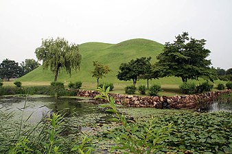
Tumulipark
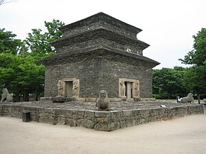
Pagoda in Bunhwangsa Temple


literature
- Gyeongju Historic Areas . In: Cultural Heritage Administration of South Korea (ed.): World Heritage in Korea . 2011, p. 78–89 (English, online excerpt from Google Books ).
Web links
Individual evidence
- ↑ a b c d UNESCO World Heritage Center: Gyeongju Historic Areas. In: whc.unesco.org. Retrieved February 4, 2017 .
- ↑ UNESCO World Heritage Center: Decision: CONF 204 XC1. In: whc.unesco.org. Retrieved February 4, 2017 .
- ↑ UNESCO World Heritage Center: Gyeongju Historic Areas. Maps. In: whc.unesco.org. Retrieved February 4, 2017 .

Heritage: Seokguram Temple and Bulguksa Temple (1995) | Haeinsa Temple - repository of the Tripitaka Koreana (1995) | Jongmyo Shrine (1995) | Changdeokgung Palace (1997) | Hwaseong Fortress (1997) | Gyeongju Historic Sites (2000) | Dolmen sites of Gochang, Hwasun and Ganghwa (2000) | Royal Tombs of the Joseon Dynasty (2009) | Historic Villages of Hahoe and Yangdong (2010) | Namhansanseong Fortress (2014) | Baekje Historic Sites (2015) | Sansa, Buddhist mountain monasteries in Korea (2018) | Seowon (2019)
Natural heritage: Jeju volcanic island and lava tunnel (2007)