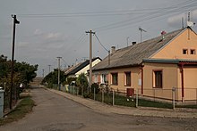
Hnízdo
| Hnízdo | ||||
|---|---|---|---|---|
|
||||
| Basic data | ||||
| State : |
|
|||
| Region : | Jihomoravský kraj | |||
| District : | Znojmo | |||
| Municipality : | Vrbovec | |||
| Area : | 129 ha | |||
| Geographic location : | 48 ° 46 ' N , 16 ° 8' E | |||
| Height: | 223 m nm | |||
| Residents : | 138 (2011) | |||
| Postal code : | 669 02 | |||
| License plate : | B. | |||
| traffic | ||||
| Street: | Dyjákovičky - Strachotice | |||
Hnízdo , until 1949 Knast (German Gnast ) is a district of the municipality Vrbovec in the Czech Republic . It is located twelve kilometers southeast of Znojmo and belongs to the Okres Znojmo .
geography
Hnízdo is located on the right side above the valley of Daníž ( Danischbach ) in the Znojemská pahorkatina ( Znojmo hills ). To the north rises the Strachotický vrch (237 m nm), in the southeast the Kočičí vrch (246 m nm) and the V Pustinách ( New Mountains , 280 m nm), south of the Vinný vrch ( Schatzberg , 294 m nm), in the southwest the Staré vinice (293 m nm) and west of the Chvalovický vrch (270 m nm).
Neighboring towns are Načeratice and Derflice in the north, Krhovice , Strachotice and Micmanice in the northeast, Slup in the east, Jaroslavice and Seefeld in the southeast, Ječmeniště in the south, Hatě in the southwest, Dyjákovičky in the west and Vrbovec in the northwest.
history
The first documentary mention of the village was probably in 1190 as Chegost ( Céhošť ) among the goods with which Duke Conrad III. Otto furnished the newly founded Louka Monastery . The place name Céhošť or Záhvozd later changed to Gnast . In the first half of the 14th century Gnast belonged to the possessions of Pertolt von Dubá and Lipá ; In 1340 he bequeathed income from grace to the monastery Aulae sanctae Mariae in Altbrünn, where he wanted to be buried in his will . In addition, there was also a Freihof in the village, the owners of which were the noblemen of Gnast. In 1351 Henslinus de Gnast , 1359 Syglein von Gnest , 1371 Henslinus dictus Meysner de Gnest alias de Schenaw and finally in 1406 Petrus de Gnast were mentioned.
In 1447 Pertolt von Leipa sold his inheritance in Gnast as an accessory for the Joslowitz estates to Achaz Finkenheimer. When the latter sold Joslowitz to Stephan Eyczinger von Eyczing with grace in 1466 , Ludwig von Tavíkovice protested and unsuccessfully asserted claims. At the beginning of the 16th century, Gnast still had a tithing obligation to the Louka monastery. In 1512, Abbot John VII asked Michael von Eyczing for a tithe from Gnast, to which his monastery had a better right. During this time the village of Gnast became extinct.
In 1517 Michael sold by Eyczing the rule Joslowitz with the market, the castle and the farm Joslowitz, the castle Hradek , the villages of Upper Tajax and Lukau , the desolate castle Schenkenberg and the desolation Gnast to Adam of Batsch Kowitz. In the corridors of the desert village, the Joslowitz rule later had a sheep farm built, which was called the Gnasterhof . In the year 1834 Gnast consisted of a single-layer government sheepfold and was conscripted to Zulb . In the middle of the 19th century a colony was established near the Gnasterhof.
After the abolition of patrimonial Gnast formed a district of the municipality of Zulb in the judicial district of Znojmo, the cadastral parish is called Oedung Gnast . From 1869 the settlement belonged to the Znojmo district. In 1869 Gnast had 232 inhabitants and consisted of 48 houses. At the end of the 19th century the Czech place name Knast was created . In 1900 326 people lived in Gnast, in 1910 there were 336. The settlement in Klein Tajax was parish and schooled . In 1930 Gnast had 347 inhabitants and consisted of 69 houses. After the Munich Agreement , Gnast was added to the German Reich in 1938 and assigned to the Znojmo district . Between June 1944 and April 1945 there was a forced labor camp for Hungarian Jews at the Gnasterhof. Most of the German-speaking residents were expelled after the end of the Second World War. In 1949 the village was renamed Hnízdo . In 1960 the settlement was made to Vrbovec, at the same time the cadastral district of Hnízdo was combined with that of Vrbovec. In the 2001 census, 159 people lived in the 51 houses of Hnízdo.
Local division
The district of Hnízdo is part of the cadastral district of Vrbovec.
literature
- Historický lexikon obcí České republiky 1869–2005 , part 1, p. 648
Web links
Individual evidence
- ↑ http://www.risy.cz/cs/vyhledavace/obce/detail?zuj=595128&zsj=186112#zsj
- ↑ http://www.risy.cz/cs/vyhledavace/obce/detail?zuj=595128&zsj=186112#zsj
- ↑ Vyhláška č. 3/1950 Sb.
- ^ Gregor Wolny : The Margraviate Moravia topographically, statistically and historically described , III. Volume: Znaimer Kreis (1837), pp. 294–306
- ↑ www.deutschland-ein-denkmal.de
- ↑ http://www.uir.cz/casti-obce/186112/Hnizdo


