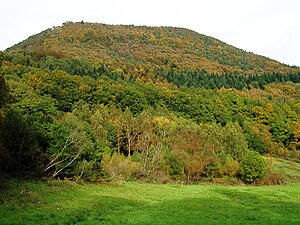
Hohenberg (Wasgau)
| Hohenberg | ||
|---|---|---|
|
The Hohenberg |
||
| height | 551.9 m above sea level NHN | |
| location | near Annweiler am Trifels ; Palatinate Forest ; Rhineland-Palatinate ( Germany ) | |
| Mountains | Wasgau | |
| Coordinates | 49 ° 12 '10 " N , 8 ° 0' 18" E | |
|
|
||
| rock | Red sandstone | |
| particularities | Hohenbergturm ( AT ) | |

The Hohenberg is a 551.9 m above sea level. NHN high mountain of the Palatinate Forest . It is located near Annweiler am Trifels in the Rhineland-Palatinate district of Südliche Weinstrasse . On the mountain there is the Hohenbergturm observation tower , a refuge, two launch ramps for hang-gliders and a launch site for paragliders .
geography
location
The Hohenberg rises in the Palatinate Forest Nature Park . It is located in the municipal areas of Annweiler am Trifels in the west and north and Albersweiler in the northeast, both of which are traversed by the Queich , as well as Birkweiler in the east and Ranschbach in the south; the latter has only small parts of the southern flank and is traversed by the Queich tributary Ranschbach . The border between Annweiler and Birkweiler runs over the mountain peak. North of the mountain lies Queich as a district of Annweiler Queichhambach . In a south-south-west direction, the Zollstock saddle ( 344.4 m ) leads to Förlenberg ( Fehrlenberg ; 533.1 m ).
Natural allocation
The Hohenberg heard in the natural environment feature unit group Haardtgebirge (no. 17) and in the main unit Dahn-Annweiler Rock land (171) for subunit Annweiler-Albers Weiler-Ausraum Trifelsland (171.0).
Protected areas
Parts of the Haardtrand - Auf dem Kirchberg nature reserve ( CDDA no. 163441; designated 1991; 83.66 hectares in size) and those of the fauna-flora-habitat area biosphere reserve extend to the north-eastern flank of Hohenberg, located in the Palatinate Forest-Vosges du Nord biosphere reserve Palatinate Forest (FFH no. 6812-301; 359.97 km² ).
Hilltop settlement
In 2015, a fortified hilltop settlement of the Urnfield culture was excavated on the Hohenberg . A probe goers had after the discovery of bracelets, axes and sickles GDKE informed that further investigation a castle wall and including arrowheads and spearheads from bronze found from the period between the eleventh and ninth century BC. Based on the location of the bronze objects, it is assumed that they are construction victims .
Hohenberg Tower
A telegraph station , part of the Paris-Metz-Landau chain , was allegedly set up on the summit region for the French Revolution after 1794 . The station was given up after the transition of the Palatinate to Bavaria in May 1816. According to French sources, this line was planned, but was never built due to lack of money.
From August to September 1879, the 9 m high Hohenberg Tower was built on the summit by the Annweiler and Landau beautification associations . The lookout tower was built like a conical pyramid using drywall construction and was completed on October 16, 1879. The interior of the tower was essentially made of rubble. A staircase on the west side of the tower led up to the viewing platform.
In the 1960s, the first stones on the tower came off due to age and in 1970 the eastern part of the tower slipped. In 1971, DM 30,000 was invested in the construction of roads for motor vehicles and the restoration of the tower.
In 2002 and October 2007 parts of the tower collapsed again. The tower was blocked and a fence made it impossible to enter the remains of the tower. The communities of Birkweiler and Annweiler-Queichhambach were able to start reconstruction in 2018 with the support of EU funds . On the occasion of the Hohenbergfest, organized by the Birkweiler fire brigade, the tower was reopened on May 1, 2019.
sport and freetime
The Schumacherfelsen lies at the western end of the summit region. Hang-gliders have built two launch ramps on these. From there you have a clear view of the three castles Trifels , Anebos and Scharfenberg . On the northwest side there is a take-off point for paragliders.
Web links
Individual evidence
- ↑ a b LANIS: Hohenberg on a topographical map from the map service of the landscape information system of the Rhineland-Palatinate nature conservation administration. Retrieved May 16, 2017 .
- ↑ Landesvermessungsamt Rhineland-Palatinate: Topographische Karte, Annweiler am Trifels , 1999, ISBN 3-89637-288-2
- ↑ Map services of the Federal Agency for Nature Conservation ( information )
- ↑ A settlement from the Bronze Age discovered. Südwestrundfunk , July 26, 2015, accessed on July 26, 2015 .
- ^ Heinz R. Wittner: Great Palatinate Guide , Ostfildern 1994, ISBN 3-8134-0106-5
- ↑ telegraphe-chappe.com: Les projets abandonnés (1794–1800). Retrieved September 5, 2016 (French).
- ^ Winfried Lang: The Optical Telegraph in the Palatinate Forest - a collective error. Retrieved September 5, 2016 . , in: Nachr. Verm. Verw. RP 3/20, pp. 137–151 (PDF; 396 kB)
- ↑ a b article The Hohenberg Tower, by Rudolf Wild, on heimat-pfalz.de
- ↑ Information board on the tower
- ↑ www.pfalz.de


