Hunter River (Tasman Sea)
| Hunter River | ||
|
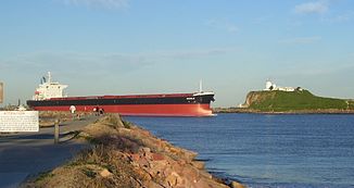
Ship at the mouth of the Hunter River at Newcastle |
||
| Data | ||
| location | New South Wales , Australia | |
| River system | Hunter River | |
| source | Mount Royal Range 31 ° 53 ′ 35 ″ S , 151 ° 27 ′ 2 ″ E |
|
| Source height | 1420 m | |
| muzzle | near Newcastle in the Tasman Sea Coordinates: 32 ° 55 ′ 7 ″ S , 151 ° 47 ′ 32 ″ E 32 ° 55 ′ 7 ″ S , 151 ° 47 ′ 32 ″ E |
|
| Mouth height | 0 m | |
| Height difference | 1420 m | |
| Bottom slope | 3 ‰ | |
| length | 468 km | |
| Catchment area | 22,000 km² | |
| Left tributaries | Omadale Brook, Moonan Brook, Stewards Brook, Woolooma Creek, Redbank Creek, Gum Flat Gully, Rouchel Brook, Sandy Creek, Muscle Creek, Whites Creek, Saddlers Creek, Saltwater Creek, Parnells Creek, Farrells Creek, Foy Brook, Fal Brook, Stanhope Creek, Glendon Brook, Lambs Valley Creek, Paterson River , Barties Creek, Williams River | |
| Right tributaries | Branch Creek, Pages Creek, Brush Hill Creek, Donalds Creek, Pages River , Dart Brook, Sandy Creek, Goulburn River , Martindale Creek, Doyles Creek, Appletree Creek, Wollombi Brook, Loders Creek, Mudies Creek, Jumpup Creek, Wallis Creek, Throsby Creek, Ironbark Creek | |
| Reservoirs flowed through | Lake Glenbawn | |
| Big cities | Newcastle | |
| Medium-sized cities | Muswellbrook , Singleton , Maitland | |
| Small towns | Ellerston, Moonan Flat, Belltrees, Scone, Aberdeen, Denman, Jervis Plains, Whittington, Elderlie, Rosebrook, Aberglasslyn, Hinton, Raymond Terrace, Hexham, Tornago | |
|
Confluence of the Hunter and Williams Rivers at Raymond Terrace |
||
The Hunter River is a river in the east of the Australian state of New South Wales . It rises in the Mount Royal Range south of the Liverpool Range at around 1420 m above sea level and flows first south and then east to the Tasman Sea .
The cities of Maitland and Newcastle are directly passed along its course . The river has a length of 438 km.
history
The Hunter River was explored by European explorers in the 1790s. In June 1796, fishermen seeking shelter from the bad weather found coal here, and so the river was initially called the Coal River . In 1797 it was renamed Hunter River (after Captain John Hunter , then governor of the British colony of New South Wales).
From 1826 to 1836 convicts built the 264 km long Great North Road that connects Sydney to the Hunter Valley .
There were large floods on the Hunter River, e.g. B. the 1955, which devastated cities along the river, especially Maitland. In 2007, there was another flood that should be taken seriously.
geography
The Hunter Valley offers one of the best routes into the interior of New South Wales as there are no higher mountains or other obstacles. It is the largest lowland on the state's coast and is drier than most of the other coastal areas in New South Wales due to the wild mountains in the north. The annual rainfall varies between 1100 mm in Newcastle and only 640 mm in Merriwa and Scone on the upper reaches. In dry years the amount of rain in Newcastle can even go down to 600 mm / a and in the upper part of the valley to 375 mm / a.
On the Barrington Tops on the north side of the valley, however, the annual rainfall is up to 2000 mm, although not all falls as rain, as the temperatures there are often below freezing in July. In the lower parts of the Hunter Valley, the maximum temperature is typically 27 ° C in summer and 16 ° C in winter.
Except for the driest parts of Tasmania and a small area in the Monaro between Cooma and Nimmitable (southeast of New South Wales), the Hunter Valley is the southern limit of the fertile “black earth” (actually black vertisol ). This is the only soil in Australia with reasonable levels of soluble phosphorus . As a result, rich farmland is spreading above Singleton, where thoroughbreds are often bred. Near Merriwa and south of Singleton the soils are very sandy and barren, which is more typical for Australia. There the land is mainly used extensively as pastureland.
The main tributaries of the Hunter River are the Pages River , Goulburn River , Wollombi Brook , Paterson River, and Williams River . To dampen the floods on the Hunter River somewhat, the Glenbawn Dam was built east of Scone .
Economy and environment
Wine is also grown in parts of the Hunter Valley . This valley is also one of Australia's most important coal mining areas. The most important environmental problems are flooding, climate change and water loss from coal mining.
See also
Web links
Individual evidence
- ↑ a b Map of Hunter River, NSW (1420 m - 241 m) . Bonzle.com
- ↑ a b Map of Hunter River, NSW (217 m - 0 m) . Bonzle.com
- ^ Clark Manning: A History of Australia . Volume 1 (1981). ISBN 0-522-84008-6 . Chapter 8
- ^ The Convict Trail Project . ConvictTrail.org ( Memento of the original from October 17, 2013 in the Internet Archive ) Info: The archive link was inserted automatically and has not yet been checked. Please check the original and archive link according to the instructions and then remove this notice.

