Incahuasi District
| Incahuasi District | |
|---|---|
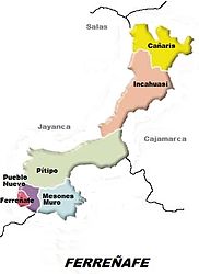
 Location of the Incahuasi district (salmon-colored) in the Ferreñafe province |
|
| Basic data | |
| Country | Peru |
| region | Lambayeque |
| province | Ferreñafe |
| Seat | Incahuasi |
| surface | 443.9 km² |
| Residents | 13,858 (2017) |
| density | 31 inhabitants per km² |
| founding | 17th February 1951 |
| ISO 3166-2 | PE-LAM |
| politics | |
| Alcalde District | William Hidalgo Manayay Manayay (2019-2022) |
| Church in Incahuasi, procession in 2011 | |
Coordinates: 6 ° 14 ′ S , 79 ° 19 ′ W
The Incahuasi district ( Quechua Inka wasi , "House of the Inca") is located in the Ferreñafe province in the Lambayeque region in northwestern Peru . The district was established on February 17, 1951. It has an area of 443.91 km². The 2017 census counted 13,858 inhabitants. In 1993 the population was 13,316, in 2007 14,230. The seat of the district administration is the 3078 m high village Incahuasi with 904 inhabitants (as of 2017). The population is mainly of indigenous descent and speaks Inkawasi-Kañaris , a variety of Quechua , as their mother tongue . In the extreme southwest of the district is the 8,328-hectare protected area Refugio de Vida Silvestre Laquipampa on the northern bank of the Río La Leche.
Geographical location
The Incahuasi district is located in the northeast of the Ferreñafe province in the Peruvian Western Cordillera . In the east, which rises 4100 m high Cerro Choicopico. The area is drained from the upper reaches of the Río La Leche to the west.
The district of Incahuasi is bordered in the extreme southwest by the district of Jayanca , in the west by the district of Salas (both in the province of Lambayeque ), in the north by the district of Kañaris (or Cañaris), in the northeast by the district of Querocotillo ( province of Cutervo ), in the southeast to the district of Miracosta ( province of Chota ) and in the south to the district of Pítipo .
Locations in the district
In addition to Incahuasi, there are the following localities in the district:
- Canchachala (206 inhabitants)
- Cueva Blanca (238 inhabitants)
- Huar Huar (317 inhabitants)
- Huasicaj (734 inhabitants)
- Janque (439 inhabitants)
- Lanchipampa (211 inhabitants)
- La Playa (251 inhabitants)
- Laquipampa (285 inhabitants)
- Machaycaj (206 inhabitants)
- Marayhuaca (401 inhabitants)
- Moyan (216 inhabitants)
- Pampagrande (211 inhabitants)
- Sinchigual (375 inhabitants)
- Tasajera (246 inhabitants)
- Totora (263 inhabitants)
- Totoras (365 inhabitants)
- Tungula (227 inhabitants)
- Uyurpampa (624 inhabitants)
Individual evidence
- ↑ a b PERU: Lambayeque region - provinces and districts . www.citypopulation.de. Retrieved March 29, 2020.
