Jübberde
|
Jübberde
Uplengen municipality
Coordinates: 53 ° 16 ′ 48 ″ N , 7 ° 45 ′ 38 ″ E
|
|
|---|---|
| Height : | 5 m above sea level NN |
| Incorporation : | 1st January 1973 |
| Postal code : | 26670 |
| Area code : | 04956 |
Jübberde is a place in the municipality of Uplengen in the district of Leer in Lower Saxony in East Frisia . The village mayor is Franz Efkes.
history
Jübberde is mentioned for the first time in the Beest description Ambts Stickhausen, Lengener Vogtey of the year 1598. There it was called Jüberden. At that time the farming village had twelve farmhouses. The livestock was 25 horses, 52 oxen, 77 cows and 65 calves.
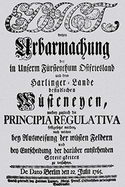
In 1744 Ostfriesland fell to Prussia through an prospectus . After Frederick the Great had signed the Edict of Reclamation in 1765 , three peatland colonies were created in the Jübberder district. All of them were founded in 1772, they are Ochsenkopf, Zinskenfehn and Bargerfehn. In the case of the latter two, however, the name ending -fehn does not indicate a settlement connected by a Fehn Canal, but only its location in the moor. Most of the new settlers came from the surrounding old Geest villages, including those that are not in the Uplengen municipality today. The new settlements developed very slowly. For Zinskenfehn in 1823 eight people are handed down to two “fire places”.
As in all of Uplengen, there is overall strong support for the CDU in Jübberde in the otherwise social democratic East Frisia. In the 1949 federal election , the CDU won the election with 51.1 percent, the SPD came in second with 30 percent - which, however, meant that the Social Democrats were able to win an above-average share of the vote compared to other communities in Uplengen. The right-wing extremist German Reich Party came to 8.9 percent, the FDP to 5.3 percent and the German party to 4.7 percent. In the decades that followed, the Christian Democrats kept the Social Democrats and all other parties at a clear distance. It achieved results between 65 percent ( 1953 ) and 56.4 percent (1972). The Social Democrats ranged between just under 19 and just under 29 percent until 1972. In the "Willy Brandt election" in 1972 , which brought the SPD a record result in East Friesland and penetrated some of the previous CDU bastions, the Social Democrats also increased their results in Jübberde: for the first time since 1949 they had 38.9 percent of the vote well above the 30 percent mark. In the 2002 federal election , the SPD was well ahead of the CDU (40.1 percent) with 47.8 percent. In the election three years later , the CDU was again just ahead of the SPD (40 percent) with 43.1 percent. The smaller parties only played a subordinate role in federal elections (2005: FDP with 5.1 percent, the Greens with 6.3 percent and Die Linke with 3.1 percent).
On January 1, 1973, Jübberde was incorporated into the new municipality of Uplengen.
The place grew considerably, mainly due to the reception of displaced persons from the former eastern areas of the German Empire. In 1946 they made up 139 of the total of 608 inhabitants. This corresponded to a share of 22.9 percent. The proportion fell significantly by 1950 to 16.9 percent (100 of 592 inhabitants).
|
|
societies
- Jübberde volunteer fire department
- Fishing club "Gut Fang" Jübberde
Personalities
- Tamme Weyert Theodor Janssen (born June 21, 1816 in Jübberde, † June 21, 1894 in Düsseldorf), painter, draftsman and engraver
credentials
- ↑ Uplengen.de: Committees ( page no longer available , search in web archives ) Info: The link was automatically marked as defective. Please check the link according to the instructions and then remove this notice. , accessed December 17, 2012.
- ↑ Christian Meyer: Historical family book of the parishes Firrel, Hollen, Ockenhausen and Uplengen (Remels)
- ^ Ortschronisten der Ostfriesische Landschaft: Jübberde , PDF file, p. 1, accessed on February 23, 2013.
- ↑ Klaus von Beyme : The political system of the Federal Republic of Germany: An introduction , VS Verlag, Wiesbaden 2004, ISBN 3-531-33426-3 , p. 100, limited preview in the Google book search, accessed on February 23, 2013.
- ^ Theodor Schmidt: Analysis of the statistics and relevant sources on the federal elections in East Friesland 1949-1972 . East Frisian Landscape, Aurich 1978, cartographic appendix.
- ^ Federal Statistical Office (ed.): Historical municipality directory for the Federal Republic of Germany. Name, border and key number changes in municipalities, counties and administrative districts from May 27, 1970 to December 31, 1982 . W. Kohlhammer GmbH, Stuttgart and Mainz 1983, ISBN 3-17-003263-1 , p. 262 and 263 .
- ^ Ortschronisten der Ostfriesische Landschaft: Jübberde , PDF file, p. 1, accessed on February 23, 2013.

