Köppel (Westerwald)
| Köppel | ||
|---|---|---|
|
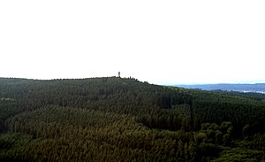
The Köppel with the Köppel observation tower (aerial view) |
||
| height | 540.2 m above sea level NHN | |
| location | near Dernbach and Montabaur ; Westerwaldkreis , Rhineland-Palatinate , Germany | |
| Mountains | Montabaurer Höhe , Westerwald | |
| Coordinates | 50 ° 25 '49 " N , 7 ° 45' 3" E | |
|
|
||
| particularities | Köppel observation tower | |
The Köppel is 540.2 m above sea level. NHN is the second highest elevation of the Montabaurer Höhe , an elongated ridge of the Niederwesterwald, after the nearby alarm pole ( 545.2 m ) . It lies on the border between Montabaur and Dernbach in the Rhineland-Palatinate Westerwaldkreis . The Köppel observation tower is on the summit .
Surname
In the dialect of the Westerwald, “Köppel” is also a general term for a hill or mountain - possibly related to the Alemannic Kapf . It probably goes back to the originally Franconian term for elevations / hills in the area and means "small head".
geography
location
The Köppel rises in the Nassau Nature Park . Its summit lies on the border of the local community Dernbach , whose core town is 4 km northeast, to the town of Montabaur , whose core town is 5.7 km east. Most of the summit region is on the Dernbacher side. To the west-south-west, the landscape leads to the alarm pole 1.5 km away .
The Masselbach rises on the north flank, the Schabebornbach and the Waldbach on the northeast flank . The Biebrichsbach, which swells at the alarm pole, flows past the south as the source of the Stadtbach . The Vorderste Bach and the Hinterste Bach spring as the source brooks of the Brexbach to the west-north-west and north-west .
Natural allocation
The Köppel belongs in the natural spatial main unit group Westerwald (No. 32) and in the main unit Niederwesterwald (324) to the subunit Montabaurer Höhe (324.1).
Nature and FFH area
The Köppel is covered by indoor red beech forests , mixed forests and coniferous forests . Parts of the fauna-flora-habitat area Montabaurer Höhe (FFH no. 5512-301; 28.11 km² ) lie on it .
Köppel observation tower
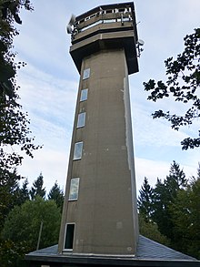
On the summit region of Koppel is in the district Dernbach of 1964-1966 from reinforced concrete built and 37.48 m high observation tower Koppel, of his 28.8 overhead covered m Aussichtsplattform a view of the Westerwald and the volcanoes in the Pellenz up to the Eifel , Taunus and Hunsrück . He carries transmission systems for the D2 mobile network. There is a restaurant near the tower.
Web links
References and comments
- ↑ a b c Map services of the Federal Agency for Nature Conservation ( information )
- ↑ Prof. Dr. Paul Vogt: The place names in Engersgau , Strüder'sche Buchdruckerei and Buchhandlung, Neuwied 1890
- ↑ Heinrich Müller-Miny, Martin Bürgener: Geographical land survey: The natural spatial units on sheet 138 Koblenz. Federal Institute for Regional Studies, Bad Godesberg 1971. → Online map (PDF; 5.7 MB)
- ↑ a b information board on the tower , on ich-geh-wandern.de
- ↑ Height according to private measurements


