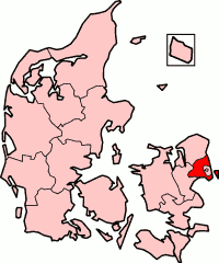
København's office
| Basic data | |
|---|---|
| Administrative headquarters: | Glostrup |
| Surface: | 525.90 km² |
| Residents: | 618,529 (2006) |
| Population density : | 1,176 inhabitants / km² |
| map | |
Københavns Amt (German: (Land-) Kreis Copenhagen ) was a Danish official commune around the capital Copenhagen ; As København's municipality, Copenhagen performed the functions of an official municipality itself, as did Frederiksberg .
Københavns Amt was created in the course of municipal reform on April 1, 1970 from the previous Københavns Amt by splitting off from Roskilde Amt , Copenhagen and Frederiksberg.
With an area of 525.9 km² it was the smallest Danish administrative district. With a population density of 1,176 inhabitants per km², it was also the most densely populated. From east to west the area was crossed by the Copenhagen – Holbæk motorway , the European roads E 20 , E 47 and E 55 led to Sweden . Copenhagen Airport was built in the Kastrup district of Tårnby municipality .
With the municipal reform on January 1, 2007, the area lies in the Hovedstaden region .
Population development
until 1921 on February 1st, from 1971 January 1st:
|
|
|
Municipalities
|
|
(Residents: as of January 1, 2006)
