Kadavu
| Kadavu | ||
|---|---|---|
| Kadavu | ||
| Waters | Pacific Ocean | |
| Archipelago | Fiji Islands | |
| Geographical location | 19 ° 3 ′ S , 178 ° 15 ′ E | |
|
|
||
| length | 93 km | |
| width | 13 km | |
| surface | 411 km² | |
| Highest elevation | Nabukelevu (Mount Washington) 805 m |
|
| Residents | 10,897 (2017) 27 inhabitants / km² |
|
| main place | Vunisea | |
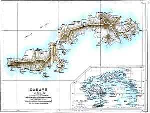
| Map from 1889, JP Thomson | ||
Kadavu ([ kaˈndaβu ], spelling also: Kandavu) is the fourth largest of the Fiji islands and the main island of the Kadavu group with an area of 411 square kilometers . She is the namesake of the eponymous province of Kadavu in the Eastern Division .
geography
With a length of 93 km and a width between 365 meters and 13 km, Kadavu is constricted in two places and thus consists of three island parts only connected by narrow strips of land. Most of the island is hilly and covered with dense tropical rainforest .
The highest peaks are the volcanic Nabukelevu (Mount Buke Levu or Ndelainambukelevu, which means great Yamsberg ), known as "Mount Washington", with 805 meters, and the Biloniyaqona (Mbiloniyanggona), known as "Mount Challenger" with 664 meters. Several smaller waterfalls tumble from the slopes.
The coastline consists of numerous bays with beaches lined with coconut trees. The Great Astrolabe Reef , one of the longest continuous reefs in Fiji, extends off the south coast and the northeastern island of Ono . Between Kadavu and the coral reef there is an extensive lagoon with water depths of up to 10 m, towards the ocean the water depth drops to 1,800 m.
population
A total of 10,897 inhabitants, mostly of Fijian origin, live on Kadavu in 69 villages scattered across the island. The only place of superordinate function is Vunisea . It is the headquarters of the Kadavu Province. There is a hospital, post office, bank and the island's market here.
| Kadavu | Population ( census ) | ||
|---|---|---|---|
| 1986 | 1996 | 2007 | 2017 |
| 9,805 | 9,535 | 10.167 | 10,897 |
history
William Bligh is considered the first European to discover Kadavu on HMS Providence on his second trip to Fiji in 1792 . In 1799, Captain Christopher Bentley followed on the return voyage from Australia on the American ship Ann & Hope . In 1827, the French commander Dumont d'Urville was almost shipwrecked on the reef, which has since been named after his ship, the Astrolabe .
In the 1870s, the Galoa Harbor whale station near Vunisea served as a port of call for passing sailing ships on their way to Australia and New Zealand . Passengers were picked up and provisions and water supplies were added. Kadavu was even discussed as the location of the new capital of the Fiji Islands, until Suva was chosen . Then the island lost its importance and still makes a sleepy impression.
Infrastructure
There are few roads on Kadavu due to the steep slopes and low population. The few villages on the eastern part of the island can only be reached by boat, as can almost all the villages on the north coast. Boats are therefore the main means of transport. Near Vunisea is Kadavu Airport , the only airport on the island to which Sun Air and Air Fiji fly daily . There are connections to Nadi and Suva . Several ships operate weekly between Kadavu and Suva, 88 km away.
economy
Kadavu is of minor importance to the Fiji Islands. It is not possible to grow sugar cane on the steep slopes . Thus the villagers mainly operate subsistence farming . The coconut for the production of oils and fats and the fishing are the only sources of income in the agricultural sector .
Tourism has grown in importance in recent years . Divers in particular visit the island because of its proximity to the Great Astrolabe Reef. The beautiful beaches and tropical diversity of plants and animals are further attractions. The lack of infrastructure and the remoteness and the resulting high prices on the island stand in the way of the expansion of tourism . There are no international resorts , only small private hotels on remote beaches, which can usually only be reached by boat. Arrival or departure is impossible in bad weather. Thus, the average length of stay of the few tourists is above average. Most of the hotels are run by foreigners, the Fijians are only employed.
Photo gallery
Web links
- Brief tourism information about Kadavu , Tourism Fiji (English)
Individual evidence
- ↑ Other sources also give a length of 50 km.
- ↑ Global Volcanism Program, Smithsonian Institution: Nabukelevu Heights of 822 meters and 838 meters are also mentioned in the literature. The first ascent took place in September 1860 by the German naturalist Berthold Carl Seemann (1825–1871) together with the first British consul in Fiji, William Thomas Pritchard (1829–1907), a second ascent in 1876 by the German naturalist Theodor Kleinschmidt .
- ↑ Percy St. Michael-Podmore calls Mount Washington in his Rambles of 1909 Mount Wellington and gives a height of 838 m. ü. M. (2750 feet), cf. Percy St. Michael-Podmore: Rambles and adventures in Australasia, Canada, India, etc. LU Gill, 1909, p. 200 . Other elevations for Mt. Challenger are 634 meters.
- ↑ a b Census 2017. (No longer available online.) In: statsfiji.gov.fj. Fiji Bureau of Statistics, March 5, 2018, archived from the original on March 20, 2018 ; accessed on March 23, 2018 (English). Info: The archive link was inserted automatically and has not yet been checked. Please check the original and archive link according to the instructions and then remove this notice.


