
Rhüden potash plant
| Groß-Rhüden potash plant | |||
|---|---|---|---|
| General information about the mine | |||
 |
|||
| other names | Carlsfund Union | ||
| Information about the mining company | |||
| Operating company | Carlsfund Union; Deutsche Kaliwerke AG | ||
| Employees | 320 | ||
| Start of operation | 1893 | ||
| End of operation | 1929 | ||
| Successor use | Industrial site | ||
| Funded raw materials | |||
| Degradation of | Carnallite, hard salt | ||
| Carnallite, hard salt | |||
| Mightiness | 40 m | ||
| Raw material content | 16-19% | ||
| Greatest depth | 970 m | ||
| Geographical location | |||
| Coordinates | 51 ° 57 '13.6 " N , 10 ° 6' 24.7" E | ||
|
|||
| Location | Am Schlörbach 19 | ||
| local community | Large male dogs | ||
| country | State of Lower Saxony | ||
| Country | Germany | ||
| District | Southern Hanover potash district | ||

The Groß-Rhüden potash mine was a potash mine in Groß-Rhüden in Lower Saxony. The shafts Carlsfund I, Carlsfund II and Hermann II belonged to it .
geography
The potash plant is located in the districts of Groß-Rhüden and Königsdahlum .
Geographical location
The Kaliflöz lies under the Heberg , north of Groß-Rhüden and south of Königsdahlum.
geology
The overburden consists almost exclusively of red sandstone, which rests on the anhydrite and is superimposed on a massive rock salt deposit of the younger rock salt. The Overhead of the younger rock salt forms of the carnallite and hard salt existing potash seam . The lying of the deposit is formed by the older rock salt.
The approximately 40 m thick coat of potash from south to north at about 20-25 ° a .
history
There was a salt spring on the western edge of Rhüden. A salt works in Rhüden that belonged to Jobst Edmund von Brabeck had already existed in the 17th century .
Carlsfund Union
The Carlsfund union was founded in Magdeburg in 1893 as a drilling company. After drilling into the potash deposit, it was converted into a mining union in 1896 . The prospect comprised a pit field of 27,000 hectares in the districts of Groß-Rhüden, Wohlhausen, Ammenhausen and Mechtshausen. As early as October 1900, a potassium chloride factory for the production of potash fertilizer was put into operation on Carlsfund I. The plant could process 200 tons of carnallite and 100 tons of hard salt per day . The administration was in Groß-Rhüden.
The round shaft Carlsfund I had a diameter of 5.5 m. The beginning of the devastation was on February 7th, 1896, in 1900 the final depth of 691 m was reached. The starting point of the shaft was slightly above the daytime facilities in the forest, so that the shaft was not lifted for days, but up to the hanging bank of the factory tunnel, over which and the subsequent conveyor bridge the Hunte ran directly for processing . Filling sites were exposed at 607, 628, 643, 658 and 683 meters. The two-tower shaft had a 10 m high, one-tier German strut frame and was equipped with a 600 hp steam hoisting machine . Production on Carlsfund I began on July 25, 1900.
In 1898, the plant received rail connection to the -Seesen Derneburg route . For this purpose, the Rothenberg marshalling yard was built below the Rothenberg. The route was 2.2 km long.
Immediately after the start of potash mining, the works management had 32 houses built for the workers who had moved in, the so-called Carlsfund colony .
The Carlsfund union held a participation rate of 19.08 ‰ in the potash indicator renewed in 1909.
Carlsfund II shaft was also a circular shaft with a depth of initially 386 m. Sinking began on October 10, 1913 to create a second opening for the day . Up to a depth of 146.5 m he was with tubbing expanded , lined below. In 1914 the sinking was postponed, presumably because of the outbreak of war. After the end of the First World War , work was resumed in 1919 and continued down to a depth of 427 m. The shaft diameter was 4.5 m; Filling sites were released at 290, 320, 390 and 405 m. Production on Carlsfund II began on July 1, 1914. In 1922 Carlsfund II was closed and backfilled.
In order to create the second escape route prescribed by the mountain police (= second day opening), a contract was concluded with the Hermann II trade union in which it was agreed that both unions would use the other day shaft as an escape route. In order to connect both pit fields underground , a 1200 m long crosscut was driven at the level of the 600 m level of the Carlsfund mine up to the marrow sheath , which penetrated on August 2, 1911 .

Carlsfund I shaft

The last remaining building of the Carlsfund chlorinated potassium factory, probably the laboratory. In front of it a concrete pillar of the conveyor bridge

Carlsfund II shaft
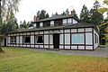
The Carlsfund II crew chews, now a restaurant

View of the Carlsfund colony

Carlsfund Colony, the decoration on the risalit represents a salt crystal in a gear


Hermann union
In 1894, the Othfresen potash drilling company was founded in Othfresen , where there was already iron ore mining and a steelworks . In 1897 - apparently after unsuccessful drilling attempts - the name was changed to Kalibohrgesellschaft Konstanz . Finally, after drilling the 7–9 m thick potash deposit on the northern slope of the Heberg, the potash drilling company was converted into the Hermann II trade union on December 18, 1899 . A field of 2500 acres (about 655 ha) was muted in the Königsdahlum district. Sinking of the Hermann II shaft began on September 16, 1905, and the shaft was initially sunk to 885 m. In 1909 it had reached its final depth of 977 m. The shaft has a diameter of 5.5 m. Filling sites were exposed at depths of 584, 838, 867, 920 and 957 m. In 1906 the plant was connected to the Derneburg – Seesen railway line via the Rothenberg marshalling yard already used by the neighboring Carslfund plant. The branch line was 3.5 km long. On February 26, 1909, potash mining began on Hermann II. The Hermann II mine had its own chlorinated potassium factory with a capacity of 300 tons of carnallite per day. 1908–1912 Carl Ludwig Reimer was director of this potassium chlorine factory. On September 23, 1909, the Hermann II union joined the German Potash Indicator and received a stake of 15.18 ‰.

Manhole cover

former administration building


Consolidation
In 1919, the Carlsfund union acquired the Kuxe of the Hermann II union. After the establishment of the German Potash Indicate on November 1, 1924, the factory received an average stake of 125% for the Carlsfund I shaft, 100% for Carlsfund II and 65% for Hermann II .
Georg Engelhardt mine
The Georg Engelhardt brown coal mine was a brown coal mine in Bornhausen am Harz, which was jointly owned by the two trade unions Carlsfund and Hermann II. It can be assumed that the lignite was used as fuel in the factories of the Carlsfund I and Hermann II pits.
Shutdown
After the Carlsfund II shaft was dropped in 1922, the potash plant was shut down in 1925 as a result of the concentration process in the German potash industry. The connecting railway was shut down in 1928.
Otmar underground relocation
The mine was planned as an underground relocation Otmar under number 5504 .
Safekeeping
The Carlsfund I shaft was sealed after production was discontinued in 1926; Carlsfund II, after being sold to a new owner, presumably filled it with the demolition material from the daytime facilities . In 1933 the seal in Carlsfund I came off and the mine drowned . In 2011 the Carlsfund I and Hermann II shafts were to be kept by the legal successor, K + S. In 2015, the Hermann II shaft was kept.
Reuse
There is an industrial plant on the grounds of the Carlsfund I factory and a campsite on Carlsfund II. The grounds of the Hermann II mine were initially intended to be used as a camping site, later the land use plan was changed so that the area should now be equipped with photovoltaics.
literature
- Journal for practical geology, with special consideration of the geology of deposits . J. Springer, Berlin 1895 ( archive.org ).
- Rainer Slotta : Technical monuments in the Federal Republic of Germany (= publications from the German Mining Museum . Volume 3 : The Potash and Rock Salt Industry , No. 17 ). German Mining Museum, Bochum 1980, ISBN 3-921533-16-3 , p. 780 .
- Thomas Reuter: The shafts of potash mining in Germany . In: Stadtverwaltung Sondershausen (ed.): SONDERSHÄUSER HEFTE on the history of the potash industry . No. 13 . City administration Sondershausen, Department of Culture, Sondershausen 2009, ISBN 978-3-9811062-3-7 , p. 209 .
Individual evidence
- ^ A b Albert Gieseler: Carlsfund potash mine. In: albert-gieseler.de. Retrieved March 25, 2018 .
- ↑ a b History panels on Rhüden and the surrounding area. Association of Nature and Home Friends Rhüden am Harz e. V., pp. 36–51 , accessed on March 25, 2018 .
- ^ Inventory of R 10-V Deutsches Kalisyndikat GmbH. 2.1 General. In: argus.bstu.bundesarchiv.de. Federal Archives, accessed on March 25, 2018 .
- ↑ a b B. cartels, syndicates and similar associations; 3. Potash certificate. In: Berlin yearbook for trade and industry. Report of the elders of the merchants of Berlin . Born in 1909. Otto Reimer, Berlin 1910, V. Economic Development in Berlin., P. 166–170 ( booksnow1.scholarsportal.info [PDF; 60.1 MB ; accessed on March 25, 2018]).
- ^ IG BCE workers in Bad Grund. Herbstwanderung Bornhausen 2010. (No longer available online.) In: igbce-badgrund.de.tl. Archived from the original on March 4, 2016 ; Retrieved October 19, 2015 . Info: The archive link was inserted automatically and has not yet been checked. Please check the original and archive link according to the instructions and then remove this notice.
- ↑ Lars Baumgarten: The potash u. Rock salt pits in Germany. 4.3 Carlsfund. In: lars-baumgarten.de. Retrieved March 25, 2018 .
- ^ Thomas Krassmann: Underground relocations of the arms industry in southern Lower Saxony. In: underground.com. Mine Archaeological Society, accessed March 25, 2018 .
- ^ Sandy Heinzel: Carlsfund and Hermann II are to be backfilled. (No longer available online.) In: Seesener Observer. observer-online.de, January 5, 2011, archived from the original on October 21, 2015 ; accessed on March 25, 2018 . Info: The archive link was inserted automatically and has not yet been checked. Please check the original and archive link according to the instructions and then remove this notice.
- ↑ Ulrich Kiehne: Around 1,800 truck loads needed for backfilling. (No longer available online.) In: Seesener Observer. observer-online.de, February 14, 2011, archived from the original on October 21, 2015 ; accessed on March 25, 2018 . Info: The archive link was inserted automatically and has not yet been checked. Please check the original and archive link according to the instructions and then remove this notice.
- ↑ a b Bockenem land use plan. (PDF; 2.6 MB) 28th amendment. (No longer available online.) August 3, 2015, formerly in the original ; accessed on March 25, 2018 . ( Page no longer available , search in web archives )
Web links
- Lars Baumgarten: The potash u. Rock salt pits in Germany. 4.3 Carlsfund. In: lars-baumgarten.de. Retrieved March 25, 2018 .
- Matthias Hoffmann: Hanover-South (HS). In: Salt pits. Retrieved on March 25, 2018 (photos of all three pits).
- Christoph Guder, Christiane Evers, Dietmar Brandes: Potash heaps as model objects of small-scale pile dynamics shown in investigations in the northern Harz foreland. (PDF; 1.45 MB) (No longer available online.) In: Braunschw. natural Schr. October 1998, pp. 641–665 , formerly in the original ; Retrieved October 18, 2015 . ( Page no longer available , search in web archives )
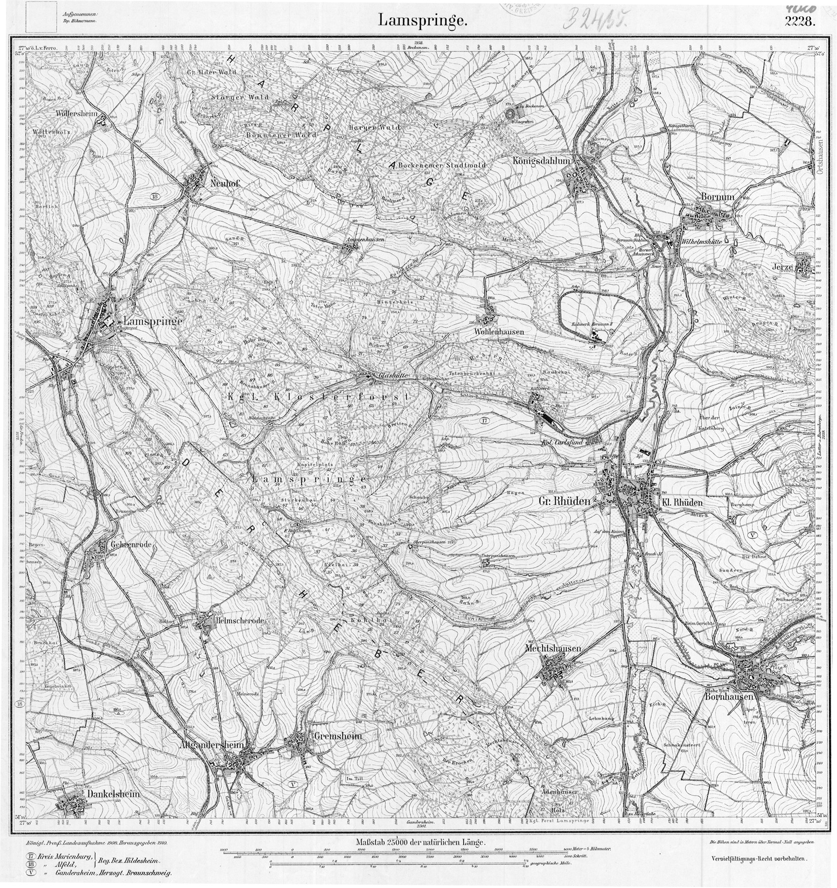
- Measuring table sheet 1.25000 4026 Lamspringe. (JPEG Image, 1654 × 1756 pixels) In: greif.uni-greifswald.de. University of Greifswald, 1908, accessed on October 19, 2015 (location with connecting railway).