Lime ears
|
Lime ears
Kressbronn municipality on Lake Constance
Coordinates: 47 ° 36 ′ 31 ″ N , 9 ° 36 ′ 3 ″ E
|
|
|---|---|
| Height : | 425 m above sea level NHN |
| Residents : | 7 (Jan 31, 2011) |
| Postal code : | 88079 |
| Area code : | 0 75 43 |
|
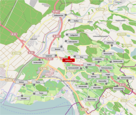
Location of the Kalkehren district in the Kressbronn municipality
|
|
Kalkehren is a district of the Baden-Württemberg community of Kressbronn on Lake Constance in the Lake Constance district in Germany.
geography
location
The district Kalkehren is about one and a half kilometers north of the center of Kressbronn, between the other districts of Betznau in the northwest, Berg in the northeast and the federal road 31 in the south, at an altitude of around 425 m above sea level. NHN .
The parcels of Betzhofer Halde and Beund belong to Kalkehren .
Protected areas
To the east, two biotopes referring to limestone spikes are marked :
- "Pond vegetation south-east of the Limestone Spars", 346 square meters
- "Wetland complex south-east of Limestone Spars", 3255 square meters
The wetland is the headwaters of the process trench, which flows into the Nonnenbach a few meters before it flows into Lake Constance .
history
Until 1934, the hamlet of Kalkehren belonged to the Hemigkofen community, from which, together with the Nonnenbach community, today's community of Kressbronn emerged.
Attractions
A cultural monument has been awarded by the Baden-Württemberg State Monuments Office in Kalkähre : the so-called “Madlener House”, built at the beginning of the 19th century (see picture).
Individual evidence
- ↑ Volker Caesar: Hardship of Preservation - Four listed farmhouses in Kressbronn ; Kressbronner Jahrbuch 1996/1997 - Volume 10, Pages 80 to 85

