Giessen Bridge
|
Giessen Bridge
Kressbronn municipality on Lake Constance
Coordinates: 47 ° 37 ′ 48 " N , 9 ° 35 ′ 53" E
|
|
|---|---|
| Height : | 425 m above sea level NHN |
| Residents : | 17 (Jan 31, 2011) |
| Postal code : | 88079 |
| Area code : | 0 75 43 |
|
Location of the Gießenbrücke district in the Kressbronn municipality
|
|
Pour bridge is now a district of the municipality Kressbronn am Bodensee in Baden-Württemberg Bodenseekreis in Germany .
location
Gießenbrücke is located around three and a half kilometers north of the center of Kressbronn on the bridge over the Argen , between the Betznau district of Kressbronn in the southeast, the Oberdorf district of Langenargen in the south, the city of Tettnang in the northwest and the Apflau district of Tettnang in the north.
history
The hamlet, formerly also called Zollbrück , owes its existence to the significant Argen crossing on the Lindau - Ravensburg - Ulm road . A bridge is mentioned for the first time in 1374.
The bridge at Giessen offered until 1835 the only way the evil one between the southern towns of Langenargen and Gohren , Tunau , Reute or Schnaidt - Kressbronner today districts - to cross on foot.
The tariff was in 1730 built customs house raised on the Western side.
Until April 1, 1937 Gießenbrücke was under the jurisdiction of the municipality of Oberdorf.
traffic
bridges
A covered wooden bridge from the years 1822/24 was blown up towards the end of the Second World War and replaced by a modern bridge.
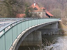
Today's bridge was officially opened to traffic on August 5, 2000 after a construction period of around 20 months - delayed by the two floods in February and May / June 1999 - it had been possible to drive on since May 26. The construction costs amounted to 2.4 million D-Marks . The building number is 8323642. The Argen is crossed here by the district road 7709; the bridge forms the link from Langenargen and Tettnang to Kressbronn, Laimnau and Langnau.
Local public transport
Gießenbrücke is integrated into the local public transport network via a stop of the Bodensee-Oberschwaben Verkehrsverbund (bodo).
Hiking trails
Among other things, the eastern branch of the Upper Swabian Jakobweg , which leads from Brochenzell via Tettnang and through the Tettnang Forest , to the St. Jakobus Chapel in the Bavarian Nonnenhorn , runs through Gießenbrücke .
← Previous location: Tettnang | Giessen Bridge | Next town: Heiligenhof →
Attractions
In Gießenbrücke, today's inn "Zum Zollhaus", formerly a hereditary farm of the Counts of Montfort and later a post office of the Thurn und Taxis family , is a listed building. It has been owned by the Kramer family since 1816.
level
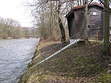
About 200 meters downstream, on Kressbronner side, which is level Casting / Argen the flood forecasting center Baden-Württemberg and the State Institute for Environment, Measurements and Nature Conservation Baden-Württemberg (LUBW); The operator is the Tübingen regional council . The level zero point is 420.13 m above sea level. NN .
Statistical values
- Average of the lowest water level 1980–2003: 0.29 m / 4.87 m³ per second
- Average water level for the years 1980–2003: 0.57 m / 20.50 m³ per second
- Historic high, flood on May 22, 1999: 3.58 m
Protected areas
By decree of the regional council of Tübingen on December 16, 1997, large parts along the Argen were declared a nature reserve and in the extended area a landscape protection area; it bears the official name " Argen ". Preservation and care of the natural argent are the primary protective purpose. Below Gießenbrücke, the river bed and bank strips, the flood dams, alluvial and swamp forests, silting ponds , moors and swamps , adjacent reed beds , litter and wet meadows with irises and orchids , wet meadows rich in sedge and rushes, orchards and remnants of the Argen estuary should be mentioned . Above the village, the river bed with its predominantly gravel banks and gravel banks, the near-natural alluvial forests, an alluvial forest island, natural swamp and swamp forests, bogs, swamps, spring areas, ponds, reed areas and wet meadows, as well as numerous unadulterated, natural or near-natural impact, slide - and slide slopes on the edge of the valley with similarly natural hillside forests and open rock formations.
Web links
Individual evidence
- ^ Landesdenkmalamt Baden-Württemberg, "List of cultural monuments, part A 1 - immovable architectural and art monuments including objects of medieval archeology"


