Atlas furnace
|
Atlas furnace
Kressbronn municipality on Lake Constance
Coordinates: 47 ° 36 ′ 23 " N , 9 ° 37 ′ 16" E
|
|
|---|---|
| Height : | 478–487.6 m above sea level NHN |
| Residents : | 26 (Jan 31, 2011) |
| Postal code : | 88079 |
| Area code : | 07543 |
|
Location of the Atlashofen district in the Kressbronn municipality
|
|
Atlas Hofen is a municipality Kressbronn am Bodensee in Baden-Württemberg Bodenseekreis in Germany .
location
The district of Atlashofen is located two kilometers northeast of the center of Kressbronn between the other districts of Berg in the west, Hüttmannsberg in the south, Nitzenweiler in the northeast and Riedensweiler in the east.
Hiking trails
Way of St. James
Among other things, the eastern branch of the Upper Swabian Jakobweg , which leads from Brochenzell via Tettnang and whose destination is the St. Jakobus Chapel in the Bavarian Nonnenhorn , runs through Atlashofen .
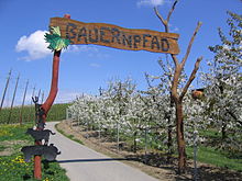
Farmer's Path
For the tenth anniversary of the Year of the Farmer initiative , the former fruit and wine nature trail was opened as the Kressbronn Farmer's Trail on June 16, 2007 after months of work, redesign, redesign and expansion by the community together with local farmers and rural women . On a roughly two-and-a-half kilometer circular route between the districts of Berg - here the parking lot - and Atlashofen, the visitor can find out a lot of interesting facts on the topics of landscape, wine, fruit, hops, forest, dairy and cattle farming on information boards. The offer is rounded off by a fragrance box, play equipment and a hop climbing tower for younger visitors.
← Previous location: Heiligenhof | Atlashofen | Next town: Hüttmannsberg →

