Karapürçek
| Karapürçek | ||||
|
||||
| Basic data | ||||
|---|---|---|---|---|
| Province (il) : | Sakarya | |||
| Coordinates : | 40 ° 39 ′ N , 30 ° 32 ′ E | |||
| Height : | 150 m | |||
| Residents : | 7,547 (2009) | |||
| Telephone code : | (+90) 264 | |||
| Postal code : | 54430 | |||
| License plate : | 54 | |||
| Structure and administration (status: 2009) | ||||
| Mayor : | Mehmet Çoruhlu ( AKP ) | |||
| Karapürçek County | ||||
| Residents : | 12,548 (2008) | |||
| Surface: | 171 km² | |||
| Population density : | 73 inhabitants per km² | |||
| Kaymakam : | Mustafa Gül | |||
| Website (Kaymakam): | ||||
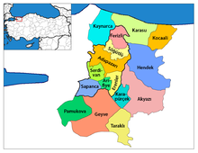
Karapürçek is a city in Turkey . It is located in the Marmara region in the province of Sakarya . Karapürçek is also the capital of the district of the same name (Turkish İlçe ). The city is located about 22 km southeast of the provincial capital Adapazarı . In 2008 the city had 7,547 and the district 12,548 inhabitants.
The region is fertile and agricultural. Grain, beans, potatoes, corn and fruit are grown. There is also animal fattening, poultry farming and silk production.
Web links
Individual evidence
- ↑ a b Turkish Institute for Statistics ( Memento from December 22, 2012 in the web archive archive.today ), accessed January 19, 2010


