
Stachus
| Karlsplatz Stachus |
|
|---|---|
|
|
|
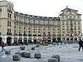
 Stachus in Munich (2014) looking towards the east |
|
| Basic data | |
| place | Munich |
| District | Old town |
| Created | 1791/92 |
| Newly designed | 1970/72 (construction of the pedestrian zone ) |
| Hist. Names | Neuhauser-Tor-Platz (1791–1797) |
| Confluent streets | Lenbachplatz , Neuhauser Strasse, Sonnenstrasse , Adolf-Kolping-Strasse, Schlosserstrasse, Bayerstrasse , Schützenstrasse, Prielmayerstrasse |
| Buildings | Karlstor , Stachus-Rondell, Palace of Justice |
| use | |
| User groups | Pedestrian traffic , bicycle traffic , individual traffic , public transport |
| Space design | Fountain (Bernhard Winkler, 1972) |
The Karlsplatz , also Stachus called, is a place in the center of Munich . It is surrounded in a semicircle by the neo-baroque Stachus-Rondell, which was built from 1899–1901 according to plans by Gabriel von Seidl . The Stachus is one of the busiest places in Europe.
history


prehistory
Karlsplatz is located at a point that was crossed by the Salzstrasse in the Middle Ages , which Duke Heinrich the Lion had moved from Föhring to Munich and to which the city of Munich owed its existence and prosperity. When the second city wall was built in the second half of the 13th century, a city gate was built here, which was first mentioned in a document in 1302 and was named Neuhauser Tor after the next place to which the street led . In the 15th century this gate was reinforced and received a front gate with two flanking side towers, which is still preserved today and forms the end of the square to the east. Also in the 15th century, an outwork in the form of a roundabout was built in front of the gate , the foundations of which were rediscovered during the construction of the Stachus basement as part of the main line of the S-Bahn . In the 17th century, a rampart was built around Munich, and instead of the roundabout, a bastion of the rampart was built on today's Karlsplatz.
History as a place
On March 18, 1791, Elector Karl Theodor ordered the bastion in front of the Neuhauser Tor to be razed and the access to the gate to be redesigned. The corresponding work began in August.
Naming
_(Zeno_Ansichtskarten).jpg)

On the corner of Sonnenstrasse / Bayerstrasse, where the Kaufhof is today, there was a house in the 18th century that had been owned by the Föderl family since 1710, who served beer there and in the garden. Since 1728 a Mathias Eustachius Föderl, called "Eustach", has been listed as the host. After him, the inn was given the name "Stachus", which is also attested as the Stachus inn and Stachus garden after the business had been taken over by another family. The name “Stachus” was then transferred from the inn to the place where it was located. However, Eustach Föderl was apparently no longer known in the 19th century, so that other explanations for the name were looked for. For example, B. Felix Joseph Lipowski in his prehistory of Munich in 1815 the name Stachusgarten from "the gentlemen's sting shots", a medieval shooting range for arrow shooters in front of the Neuhauser Tor.
After its construction in 1791, the square was officially called "Neuhauser-Tor-Platz" after the gate located on it, similar to Isartorplatz and Sendlinger-Tor-Platz today. After the Neuhauser Tor was renamed Karlstor in July 1792 in honor of the Bavarian Elector Karl Theodor , the square initially retained its old name, only in February 1793 the name "Karls-Thor-Platz" is occupied. On April 27, 1797, Karl Theodor approved the renaming of the square in Karlsplatz. The fact that the Elector of the Palatinate was extremely unpopular with the people of Munich is perhaps one reason why the old name “Stachus” remained in use; in Munich it is even part of the electronic S-Bahn and U-Bahn announcements.
The city of Germering is located on the western outskirts of Munich . There is a large intersection at which five - originally even six - streets converge and in the middle of which there is a fountain. In view of the similarity to the Munich Stachus, this intersection is popularly called "Kleiner Stachus". Although this name is only official as a bus stop, it is also used in the local press and in the city council.
description


During the economic miracle, the Stachus developed into the busiest place in Europe, until its eastern part with Neuhauser Straße , which begins at Karlstor and ends at Färbergraben, was converted into a pedestrian zone . This is evidenced by the Munich saying “It's like at Stachus”. The conversion into a pedestrian zone took place in the run-up to the XX. Olympic Games in Munich.
The roundabout buildings delimiting the square were built between 1796 and 1802. From 1899 to 1902 they were increased and rebuilt by Gabriel von Seidl . In the process, the inner closing structures in front of the side towers of the Karlstor were torn down so that the Karlstor was freely visible from the square. On the two corner towers at Karlstor there were originally two domes that were destroyed in the Second World War and have not been reconstructed to this day.
The Hotel Königshof and the Pini-Haus are in a direct line of sight on Sonnenstrasse opposite the Karlstor . On the north-western side, the square was initially limited by the Old Botanical Garden . The Palace of Justice was built on this site in 1891 . On the southwest side, where the Stachusgarten used to be, is now the Kaufhof designed by the architect Theo Pabst .
The fountain was set up in 1970 as part of the construction of the Munich S-Bahn; During this time, the shopping center below the square was built - the Stachusbauwerk, the largest underground structure in Europe, and the underground U and S-Bahn station Karlsplatz (Stachus) . The design of the fountain comes from Bernhard Winkler (1972). At night the fountain is illuminated by 28 lights.
In 1970 the underground structures, the actual Stachus building, were also opened. The four basement floors comprise around 500,000 cubic meters under 25,000 m² of built-up area. The pioneering project at the time was planned by the Obermeyer engineering office, now OBERMEYER Planen + Beraten GmbH. A special feature was the cover construction , which was done from "top to bottom".
In 2005 the Stachusbauwerk (with the exception of the railway facilities) was sold by the City of Munich to Stadtwerke München . In LBBW, the company found an investor who wanted to renovate these facilities by 2009 for a total of 30 million euros.
Since February 2007, the shopping center has been operated by LBBW Immobilien GmbH under the name “Stachus Passagen”. In the same year, it carried out an architecture competition for modernization and renovation, from which the Munich architecture firm Allmann Sattler Wappner emerged as the winner. The construction work was completed in early summer 2011.
For the Stachusbauwerk, the city administration issued the Stachusbauwerk statutes as early as 1971 , according to which (for example) people are not allowed to spend the night, consume alcohol, beg, make music or sit there.
The McDonald’s branch in the southern Rondellbau is one of the world 's best-selling; In the first half of 2006, it was the top-selling of all branches.
Since 2018 there has been a Sky of Fame with Munich personalities on the ceiling of the Stachus Passages .
photos

View from the west of the fountain and Karlstor

Palace of Justice on the western edge of Karlsplatz
Southern half of the Karlsplatzrondell

Kaufhof on the west side

Karlstor

At dusk


literature
- Hans Lehmbruch: A new Munich. Urban planning and urban development around 1800. Research and documents. Buchendorfer Verlag, Buchendorf 1987, without ISBN.
- Mathias Irlinger: Munich. Infrastructures in urban areas in the 19th and 20th centuries. In: Antje Matern (ed.): Urban infrastructure landscapes in transformation. Cities - places - spaces. Transcript, Bielefeld 2016, ISBN 978-3-8376-3088-6 , pp. 43-64. ( limited preview of Google Books )
- Helmuth Stahleder : House and street names in Munich's old town. Hugendubel, Munich 1992, ISBN 3-88034-640-2 , pp. 171, 605 ff.
- Helmuth Stahleder, Richard Bauer (ed.): Chronicle of the city of Munich.
- Volume 1: Duke and bourgeois town. The years 1157–1505. Dölling and Galitz, Ebenhausen / Hamburg 2005, ISBN 3-937904-10-7 .
- Volume 3: Forced Shine. The years 1706-1818. Dölling and Galitz, Ebenhausen / Hamburg 2005, ISBN 3-937904-12-3 .
- Karl Stankiewitz: The Stachus. Where Munich became modern. MünchenVerlag, Munich 2006, ISBN 3-937090-14-2 .
See also
Web links
Individual evidence
- ↑ Stahleder: Chronik, Vol. 1, p. 67
- ^ Michael Weithmann: Castles in Munich . Stiebner Verlag, Munich 2006, ISBN 3-8307-1036-4 , pp. 135 .
- ↑ Stahleder, Chronik, Vol. 3, pp. 407, 410
- ↑ a b c Stahleder: House and Street Names, p. 171
- ^ Felix Joseph Lipowski: Primeval Stories of Munich . II. Theil, Munich, 1815, p. 466, 470 ( online )
- ↑ Stahleder: Chronik, Vol. 3, p. 453
- ↑ Stop Kleiner Stachus, Germering - timetable, departure & arrival. Retrieved October 30, 2019 .
- ^ "Little Stachus" - City of Germering. Retrieved October 30, 2019 .
- ↑ A picture of a city . In: sueddeutsche.de . August 24, 2015, ISSN 0174-4917 ( sueddeutsche.de [accessed June 5, 2019]).
- ↑ muenchen.de: The Stachus building
- ↑ Archived copy ( Memento from May 28, 2012 in the Internet Archive )
- ↑ Archived copy ( Memento from July 16, 2011 in the Internet Archive )
- ↑ McDonald's increases its sales ( Memento of the original from January 17, 2010 in the Internet Archive ) Info: The archive link was automatically inserted and not yet checked. Please check the original and archive link according to the instructions and then remove this notice.
- ↑ https://www.muenchen.tv/mediathek/video/muenchner-stars-am-sky-of-fame-im-stachus
Coordinates: 48 ° 8 ′ 21 ″ N , 11 ° 33 ′ 57 ″ E