
Castles of Walheim
| Castles of Walheim | |
|---|---|
| limes | ORL 57 ( RLK ) |
| Route (RLK) |
Neckar-Odenwald-Limes Neckar line |
| Dating (occupancy) | A) before / at 90 ( n.a.A. around 98) to around 159 B) around 115/125 to around 159/160 C) Vicus up to around 235/260 |
| Type | A) Cohort fort B) Numerus fort |
| unit | A) Cohors I Asturum equitata (?) B) Unknown number |
| size | A) 134 m × 156 m = approx. 2.1 ha B) 64 m × 109 m = 0.7 ha |
| Construction | Aa) wood-earth-fort A.b) stone -fort B) wood-earth-fort |
| State of preservation | A) overbuilt ground monument, partly marked in the road surface B) overbuilt ground monument C) "House 19" of the vicus preserved; museum |
| place | Walheim |
| Geographical location | 49 ° 0 '38.6 " N , 9 ° 9' 16" E |
| height | 181 m above sea level NHN |
| Previous | ORL 56 Heilbronn-Böckingen Fort (north) |
| Subsequently | ORL 58 Benningen Fort (south) |
The forts of Walheim were two Roman military camps , whose crews were responsible for security and surveillance tasks on the Neckar line of the Neckar-Odenwald-Limes . The structural remains of the two garrisons were discovered in the area of today's village of Walheim , a municipality in the Ludwigsburg district in Baden-Württemberg .
location

The forts of Walheim are located on a raised terrace on the left bank of the Neckar , north of the Neckar loop from Besigheim and the mouth of the Enz . The former military camps were naturally bounded to the east by the river and to the west by mountains. The area on which the two forts and the spacious vicus are located is cut through by the “Baumbach”, the valley of which in ancient times was around four meters lower than it is today.
The valley basin location, which at first glance appears to be quite unfavorable for a Limes camp and does not allow any far-reaching view, was probably compensated for by other location factors in ancient times. The nearby mouth of the Enz and the good connection to the Roman roads leading into the hinterland may have played a role in the establishment of the garrison.
A Roman Neckar harbor and a ford connecting the two banks can be assumed with some probability.
Research history
The Roman presence in the Walheim area was suspected as early as the middle of the 19th century. The southern fort I was located in the middle of the town center in 1886 and was archaeologically examined for the first time . In 1894 further excavations were carried out by the Reich Limes Commission . Since then, scientific investigations have taken place again and again, often as emergency or rescue excavations in connection with urban development measures. In 1911 there were first indications of a Roman pottery quarter, in 1957 the existence of a Neckar harbor became apparent, and in 1967/68 parts of a giant column of Jupiter appeared. In particular, the research of the vicus became more and more important. In the years from 1980 to 1988, the excavations in Walheim, which were carried out by the Baden-Württemberg State Monuments Office and under the direction of Dieter Planck , formed a focus of Baden-Württemberg state archeology. In this context, the northern fort II was discovered in 1982.
Military camp
The forts of Walheim consist of a cohort fort (Fort I) located under the center of today's municipality of Walheim and a numerus fort (Fort II) about 350 m north of it .
Castle I.

The fort, which was located under the medieval town center of Walheim and was located in the 19th century, is a cohort fort which, with sides of 134 by 156 meters, covers an area of around 2.1 hectares. The military camp is presumably Domitian , but at the latest of early Trajan origin. Initially it was a wooden and earth construction military camp that was converted into a stone fort in the early Cantonese period. Overall, it was used for military purposes until shortly after the middle of the 2nd century and is likely to have been abandoned around 159 when the Limes was moved forward to the east.
The cohort camp with its Porta praetoria (main gate) faced east-southeast, towards the Neckar. A pointed trench surrounding the fort, 7.5 meters wide and 1.5 meters deep , has been verified, a second trench is not completely secured. A wall with four corner towers, four double gate towers and two lateral intermediate towers in the area of the Retentura was found to protect the four-gate camp in its stone construction phase. Hardly any statements can be made about the interior development due to numerous overlapping disturbances from the post-fort period; only a part of the centrally located Principia (staff building) was cut off during the excavations. Most of the building finds from the interior of the camp, however, come from the use after 159, when the abandoned fort had already been integrated into the vicus .
The location of the fort can still be clearly seen in the city plan today. The main street corresponds to the approximate course of the former Via principalis , the Bahnhofstraße that of the Via decumana and the Neckarstraße that of the Via praetoria .
In general, the Cohors I Asturum equitata ("1. Partly Mounted Asturian Cohort"), an auxiliary group of around 500 men , is assumed to be the main unit of the Walheim cohort fort , but there is currently no reliable archaeological evidence for this. As part of the relocation of the Limes in an easterly direction around 159, it was moved to the Mainhardt Fort .
Castle II
Fort II is located north of the Baumbach depression and was only discovered in 1982 when a federal road was being re-routed. With sides of 109 by 64 meters, it covers an area of around 0.7 hectares. It corresponds to the size of a typical numerus fort, but has an unusual, elongated shape.
The finds suggest that it originated in the late Trajanic to early Hadrian times and that military use ended shortly after the middle of the 2nd century around the year 159. Subsequently, the area was included in the north vicus and used for civilian purposes. Two construction phases could be verified for the period of military use. In both cases it is a wood-earth construction, a conversion into a stone fort did not take place.
Like the cohort camp, Fort II was oriented towards the Neckar with its praetorial front. Initially it was surrounded by a W-shaped double moat, which was later replaced by a simple pointed moat. A turf wall with defensive towers at the rounded corners can be used as a fence. In addition, the probably four camp gates were flanked by double towers, and two intermediate towers could be detected in the rear storage area between the side gates and the corner towers.
Inside the fort three team barracks, a stable or a coach house and a horreum (granary) were found, but no staff building. In the second construction phase, the crew quarters were replaced by large, elongated stores or workshops.
Nothing is known about the units stationed here, but based on the findings it can be assumed that it was initially a special unit (replenishment, pioneers, etc.) and that the camp was later used as a depot. The crew could have been a number of about 240 men consisting of three centuries, but possibly also the equally strong vexillatio (detachment) of a legion.
Vicus

The civil settlement area, the vicus , extended almost over the entire valley basin and reached an extension of a good one kilometer along the river and a good half a kilometer in a west-east direction. Its center was between the two forts. In addition, there was a small bridgehead on the right bank of the Neckar, approximately at the level of the cohort fort or today's town center. This makes the vicus of Walheim one of the larger and more important vici on the upper Neckar and roughly corresponds to those of Wimpfen and Köngen. Even after the two forts were closed around 159, the vicus continued to exist. It prospered as a trading center on the Neckar and was only given up in the late Severe period. Horizons of destruction that would indicate a direct connection with the Alemanni incursions of this time are missing. On the other hand, the number of coins found suddenly declined from 233/235 onwards, so that it must be assumed that the settlement was largely abandoned during this period. The remaining settlement should then be gradually deserted.
The vicus as a whole is divided into two parts, the dividing line of which is marked by the tree brook running in a west-east direction. While it was not possible to get a more or less complete picture of the settlement in the southern vicus due to the denser medieval and modern buildings, the northern vicus could be examined in detail as part of the major excavation campaigns between 1980 and 1988. Since then, the vicus of Walheim has been one of the best-researched settlements of its kind in southern Germany, and the extensive publication, which was first published in 2004, is considered a pioneering publication in Roman provincial archeology.
It was possible to gain important insights into the planned layout of Roman cities. Numerous strip houses were uncovered and examined, including the so-called "House 19", which was completely preserved in its floor plans and its basement, which was later preserved and made accessible to the public under a protective structure.
A continuity of the settlement between Roman and post-Roman times could not be proven archaeologically and seems unlikely, despite the fact that Fort I is reflected in the medieval town plan. It is more likely that the later Alemannic settlement was based on the Roman roads and possibly also used existing ruins and foundations.
Finding and securing findings
The extensive finds from the fort and vicus excavations are now mainly in the Provincial Roman Collection of the Württemberg State Museum in the Old Castle in Stuttgart , in the Limes Museum in Aalen and in the municipality of Walheim itself. The location of the Porta principalis dextra and the Porta principalis sinistra are through marked a prominent paving in the main street of Walheim.
The so-called “Building 19” of the vicus was preserved in situ and a protective house was built over it. This is where the Museum Römerhaus Walheim , opened in 1991, is located , in which, in addition to the Roman building, finds from the excavation campaigns from 1980 to 1988 are presented. The "Römerhaus" is a branch museum of the Archaeological State Museum Baden-Württemberg and is developed in cooperation with the Walheim community and the "Förderverein Römerhaus Walheim e. V. "operated.
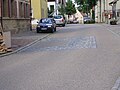
Pavement marking on the main road

Entrance to the Roman house with a replica of the giant Jupiter column from Walheim

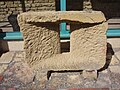
Stone of the four gods on the base of the giant column of Jupiter, relief with Hercules, in the right the club, in the left the Hesperides apples
Stone that formed the massive basement window in the basement of so-called House 3


Monument protection
The ground monuments “Kastelle von Walheim” are protected as registered cultural monuments in the sense of the Monument Protection Act of the State of Baden-Württemberg (DSchG) . Investigations and targeted collection of finds are subject to approval, and accidental finds are reported to the monument authorities.
See also
literature
- Klaus Kortüm : Walheim . In: Dieter Planck (Ed.): The Romans in Baden-Württemberg . Theiss, Stuttgart 2005, ISBN 3-8062-1555-3 , p. 350 ff.
- Klaus Kortüm and Johannes Lauber: Walheim l. Fort II and the subsequent settlement . Theiss, Stuttgart 2004, ISBN 3-8062-1879-X .
- Dieter Planck: The Roman whale home. Excavations 1980–1988 . Landesdenkmalamt Baden-Württemberg, Stuttgart 1991, ISBN 3-927714-38-0 , (Archaeological information from Baden-Württemberg, 18).
- Dieter Planck: Walheim . In: Filtzinger, Planck and Cämmerer (eds.): The Romans in Baden-Württemberg . 3. Edition. Theiss, Stuttgart 1986, ISBN 3-8062-0287-7 , p. 596 ff.
- Adolf Mettler in the series Der Upper Germanic-Raetian Limes of the Roemerreiches (Eds. Ernst Fabricius , Felix Hettner , Oscar von Sarwey ): Department B, Volume 5, Fort No. 57 (1897).
Web links
- Fort II and Roman house on the private website for the preservation of monuments in Baden-Württemberg by Wolfgang M. Werner
- Museum Roman House Walheim
- Roman house Walheim on the side of the Archaeological State Museum Baden-Württemberg, branch in Konstanz
Remarks
- ^ Dieter Planck: The Roman whale home. Excavations 1980–1988 . Landesdenkmalamt Baden-Württemberg, Stuttgart 1991, ISBN 3-927714-38-0 , (Archaeological information from Baden-Württemberg, 18), assumes a missing Porta decumana, Klaus Kortüm and Johannes Lauber: Walheim l. Fort II and the subsequent settlement . Theiss, Stuttgart 2004, ISBN 3-8062-1879-X , on the other hand, assumes four goals.

Fort Wimpfen im Tal | Heilbronn-Böckingen fort | Castles of Walheim | Benningen Fort | Fort Stuttgart-Bad Cannstatt | Castle Köngen (Grinario) | Rottenburg Castle (Sumelocenna) | Sulz Castle | Waldmössingen Castle | Castles of Rottweil (Arae Flaviae)