Little Nallenberg
| Little Nallenberg
(Little Nalle)
|
||
|---|---|---|
|
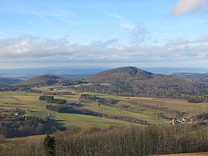
View from the Simmelsberg to the west northwest to the |
||
| height | 704.1 m above sea level NHN | |
| location | at Rommers ; District of Fulda , Hessen ( Germany ) | |
| Mountains |
Rhön ( Milseburger Kuppenrhön ) |
|
| Coordinates | 50 ° 26 '5 " N , 9 ° 52' 46" E | |
|
|
||
| rock | basalt | |
The Kleine Nallenberg , also called Kleine Nalle , near Rommers in the eastern Hessian district of Fulda is 704.1 m above sea level. NHN high mountain of the Milseburger Kuppenrhön , part of the low mountain range Rhön . The northern neighbor is the Große Nallenberg ( 768.3 m ).
geography
location
The Kleine Nallenberg is located in the Hessian Rhön Nature Park and the Rhön Biosphere Reserve . Its summit rises - viewed clockwise - 3.3 kilometers southwest of the core town of Gersfeld , 2.5 km west-southwest of Sparbrod , 2.5 km west-northwest of Rengersfeld , 1.3 km northwest of Rommers , 2.8 km east of Gichenbach and 3 km (as the crow flies ) southeast of Altenfeld . To the north, its landscape leads over the Großer Nallenberg, 1 km away, to the valley of the Fulda , and to the south it drops into that of the Fulda tributary Rommerser Wasser . In the transition area of the two Nallenberge rises the north-north-east facing Fulda tributary Scheibelbach and the Römergraben south-west to the Rommerser Wasser . East of the Kleiner Nallenberg rises, among other things, the Teufelsgraben , which flows south to the Rommerser Wasser .
Natural allocation
The Kleine Nallenberg belongs to the natural spatial main unit group Osthessisches Bergland (No. 35), in the main unit Vorder- und Kuppenrhön (with land ridge) (353) and in the subunit Kuppenrhön (353.2) to the natural area Milseburger Kuppenrhön (353.21).
Protected areas
Parts of the Hessian Rhön landscape protection area ( CDDA no. 378477; designated 1967; 410.31 km² in size) and those of the Hessian Rhön bird protection area (VSG no. 5425-401; 360.8 km²) are located on the Kleiner Nallenberg . To the north and east of the mountain are areas of the fauna-flora-habitat area Hochrhön (FFH No. 5525-351; 48.09 km²), to the south those of the FFH area Haderwald (FFH No. 5525-352; 17, 94 km²) and to the south-west of the FFH area Upper and Middle Fuldaaue (FFH no. 5323-303; 25.38 km²).
Traffic and walking
Beyond the Great Nallenbergs extends Fuldatal between old field and Gersfeld approximately in the east-west direction, the Federal Highway 279 , the east of the Gersfeld little Nallenbergs in direction south-southwest to Rommers leading circuit road 66 branches off. The latter runs from there in the valley of the Rommerser Water towards west-north-west to Gichenbach and on to Schmalnau to the B 279. For example, starting at these roads, the mountain can be hiked on mostly forest trails and paths. The Heidelsteinweg ( HWO 5) of the Rhön Club crosses the saddle between the two Nallen Mountains .

