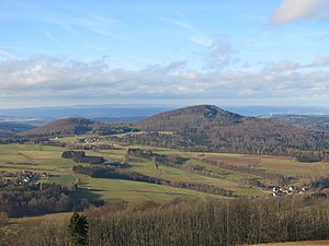
Great Nallenberg
| Great Nallenberg
(Great Nalle)
|
||
|---|---|---|
|
View from the Simmelsberg to the west-northwest to the |
||
| height | 768.3 m above sea level NHN | |
| location | near Gersfeld ; District of Fulda , Hessen ( Germany ) | |
| Mountains |
Rhön ( Milseburger Kuppenrhön ) |
|
| Dominance | 3.7 km → Bremerkopf | |
| Notch height | 620 m ↓ Rommerser Ziegelhütte | |
| Coordinates | 50 ° 26 '38 " N , 9 ° 52' 43" E | |
|
|
||
| rock | basalt | |
| particularities | former basalt quarry | |
The Große Nallenberg , also called Große Nalle , near Gersfeld in the eastern Hessian district of Fulda is 768.3 m above sea level. NHN high mountain of the Milseburger Kuppenrhön , part of the low mountain range Rhön . The southern neighbor is the Kleine Nallenberg ( 704.1 m ).
geography
location
The Große Nallenberg is located in the Hessian Rhön Nature Park and the Rhön Biosphere Reserve . Its summit rises - viewed clockwise - 3 kilometers west-south-west of the core town of Gersfeld , 2.6 km west-north-west of Sparbrod , 2.9 km north-west of Rengersfeld , 2.2 km north-north-west of Rommers , 3 km east-north-east of Gichenbach and 2.4 km km (as the crow flies ) west-northwest of Altenfeld . To the north, its landscape drops into the valley of the Fulda , and to the south it leads over the Kleiner Nallenberg, 1 km away, to that of the Fulda tributary Rommerser Wasser . In the transition area of the two Nallenberge rises the north-north-east facing Fulda tributary Scheibelbach and the Römergraben south-west to the Rommerser Wasser .
Natural allocation
The Große Nallenberg belongs to the natural spatial main unit group Osthessisches Bergland (No. 35), in the main unit Vorder- und Kuppenrhön (with land ridge) (353) and in the subunit Kuppenrhön (353.2) to the natural area Milseburger Kuppenrhön (353.21).
Protected areas
On the Great Nallenberg are parts of the protected landscape Rhön ( CDDA -No 378,477;. 1967 expelled; 410.31 square kilometers in size) and those of the bird reserve Rhön (VSG No. 5425-401;. 360.8 square kilometers). Parts of the fauna-flora-habitat area Hochrhön extend to the south and south-west flanks (FFH no. 5525-351; 48.09 km²).
Basalt quarry
In the eastern flank of the Großer Nallenberg there is an abandoned basalt quarry, which gives it a striking appearance. In one of the basins there is a lake.
Viewing opportunities
On the wooded Großer Nallenberg, in the upper area of the former quarry, there are views of Gersfeld and surrounding mountains such as Ebersberg (Rhön) , Wachtküppel , Milseburg , Wasserkuppe , Heidelstein , Hohe Hölle , Simmelsberg , Reesberg and Mittelberg .
Traffic and walking
North past the Great Nallenberg extends Fuldatal between old field and Gersfeld approximately in west-east direction federal highway 279 , in Gersfeld the east of the small Nallenbergs in direction south-southwest to Rommers leading circuit road 66 branches off. The latter runs from there in the valley of the Rommerser Water towards west-north-west to Gichenbach and on to Schmalnau to the B 279. For example, starting at these roads, the mountain can be hiked on mostly forest trails and paths. The Heidelsteinweg ( HWO 5) of the Rhön Club crosses the saddle between the two Nallen Mountains . The mountain top can only be reached on steep, unmarked paths and paths, some of which are secured with steel cables.
Individual evidence
Web links
- View on the Große Nalle (labeling of visual targets can be activated), on panorama-photo.net


