
Vockfey
|
Vockfey
Municipality of Neuhaus
Coordinates: 53 ° 13 ′ 26 ″ N , 10 ° 56 ′ 13 ″ E
|
||
|---|---|---|
| Incorporation : | July 23, 1965 | |
| Incorporated into: | Zeetze | |
| Postal code : | 19273 | |
Location of Vockfey in Lower Saxony |
||

Vockfey is a district of the Lower Saxon community of Amt Neuhaus on the eastern bank of the Elbe , which, like the entire community, belonged to the Soviet occupation zone after the end of the Second World War and thus to the GDR since 1949 and was particularly affected by forced resettlement and demolition due to its proximity to the border was. The Neuhaus office became part of Lower Saxony in 1993 through a state treaty.
history
As early as the 13th century, farmers settled in the Elbe Marsh, which at the time was still poorly protected from floods . In Vockfey, with its districts of Kolepant, Pommau, Neu Schutschur and Groß Banratz, a number of farms soon existed. Over time, houses were built on the gable side in the direction of the Elbe along the ever-increasing Elbe dike, because in addition to protecting against flooding, this was an important connection route. The population of Vockfey rose from 64 to 162 between 1925 and 1939.
End of war
Shortly before the end of the Second World War, Vockfey was shot at from the west bank of the Elbe, which, however, hardly caused any damage to buildings on the site. After the end of the war, the Neuhaus office initially belonged to the British and from July 1, 1945 to the Soviet zone of occupation . Vockfey was therefore located directly to the east of the zone border running along the Elbe. In a letter dated July 25, 1945, the Allied Control Council was requested by the former British occupiers to agree to the change of area, since “the river Elbe forms a natural border of this region and [...] all bridges have been destroyed, so that the Armed forces subordinate to the administration of the area will have to build a new bridge. ”Although there were no fixed bridges in this area before - the crossing of the river was ensured by intact ferry connections - it can be assumed that the supply of the area by ferries was the British seemed too expensive.
First border security measures
.jpg)
In May 1952, the establishment of security devices in the form of a 500-meter restricted strip and a 5-kilometer restricted zone began along the inner-German border . The residents of the 31 houses and courtyards at that time had to rake a 10-meter control strip every day, which was not to be crossed under threat of firearms. In order to get to Vockfey, a pass was now required, and visits by relatives who were rarely allowed into the border area had to be applied for. It was forbidden to stay outdoors during the night within the 500-meter strip. The SED district leadership in Hagenow propagated that border security "served to tame West German militarism and preserve peace".
Forced relocations
As early as the first week of June 1952, the first major forced resettlements began as part of the “ Ungeziefer campaign ” in 23 villages of the Neuhaus office. According to Order 38/52 of the Ministry of the Interior of May 26th, persons and their families who were foreigners, stateless persons or not registered with the police, who had committed criminal acts and who were suspected to be re-offenders, were to be expelled which represented a threat to the anti-fascist democratic order. In files that can be viewed today, unpopular citizens were accused, for example, of listening to western radio, agitating against the GDR and the Soviet Union , refusing to vote and failing to meet agricultural tax obligations. The groups of people concerned had to leave their place of residence within 24 to 48 hours. Without having been informed of the destination, the families had to load their household goods onto trucks or tractor trailers, cattle had to remain on site and should be taken over into an agricultural production cooperative that was to be formed. The families found shelter in the eastern districts of Mecklenburg, where abandoned farms and estates were given to them. There was no lack of hostility from the local population.
After isolated actions, a second wave of forced resettlement followed in 1961 with the “ Aktion Kornblume ”, in which the Neuhaus district was once again included, but the town of Vockfey was not included. A total of 51 Vockfeyer citizens from 13 families were affected by the measures taken in 1952 and 1975.
On July 23, 1965, Vockfey was dissolved as an independent municipality as part of area changes in the Schwerin district and incorporated into Zeetze .
The aim of the GDR regime was to depopulate the border area on the Elbe, because there were frequent escapes from the GDR . Special bonuses could be used to win over factory groups and workers to demolish empty houses and farms. These actions were mainly carried out in the 1970s; there are documents in which individual measures from 1971–72 are listed. Parts of the demolition material were used for construction projects outside the exclusion zone, building rubble that was not required was sunk into the Kolepanter Brack , a 16-meter-deep water hole that was created in the 17th century after a dike breach , which is now also known as the “wet grave of Vockfey”.
Historical processing
In 1989, many former residents of Vockfey visited their old home and were shocked to discover that Vockfey, Pommau and Neu Schutschur only consisted of a few houses. The place Kolepant was completely worn out. Affected people and their relatives have gathered at the scene of the event in the open field several times since the fall of the Wall to exchange views on the suffering they experienced at the time.
When a new Elbe dike was built in 2004, sunk bricks, beams, goal posts, window arches and steel remains of the leveled part of Vockfeys were lifted. To commemorate the forced resettlement at the former inner-German border and the loss of many buildings, parts of the material found by the Association for Citizens' Encounters in the Neuhaus eV , numerous companies and private individuals were used to create a documentation center in the form of a small open house with boards with documents on its walls , Photos, maps, historical information and old tools are attached, as well as a so-called "thought pyramid". The place of remembrance was officially inaugurated in October 2006 on the occasion of the 45th anniversary of “Aktion Kornblume”.
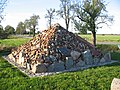
Thinking pyramid

Gravestone found in the water hole on the thinking pyramid

Documentation center


Web links
swell
- Information boards in the documentation center
- ^ Michael Rademacher: German administrative history from the unification of the empire in 1871 to the reunification in 1990. City and district of Lüneburg. (Online material for the dissertation, Osnabrück 2006).
- ↑ Report of the IG Forced Resettled Mecklenburg-Western Pomerania ( Memento of the original from February 20, 2008 in the Internet Archive ) Info: The archive link was inserted automatically and not yet checked. Please check the original and archive link according to the instructions and then remove this notice.
Dellien with Preten and Sückau | Haar with Darchau, Klein Banratz and Konau | Kaarßen with Bitter , Brandstade, Herrenhof , Laave , Privelack , Rassau and Stixe | Neuhaus with Rosien | Stack with Gutitz, Pommau, Vockfey and Zeetze | Sumte with Gülstorf, Krusendorf , Neu Garge , Niendorf , Stiepelse and Viehle | Tripkau with Bohnenburg , Gosewerder, Laake , Pinnau , Raffatz, Strachau, Wehningen and Wilkenstorf