Chemnitz motorway junction
| Chemnitz motorway junction | |
|---|---|
|
|
|
| map | |
| location | |
| Country: | Germany |
| State : | Saxony |
| Coordinates: | 50 ° 51 '5 " N , 12 ° 50' 31" E |
| Height: | 320 m above sea level NN |
| Basic data | |
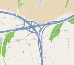
| Design type: | Shamrock with tangent solutions |
| Bridges: | 3 (motorway) / 2 (other) |
| Construction year: | 1939 |
| Last modification: | 2006 |
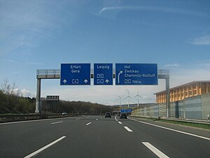
| The federal highway 4 at the Chemnitz junction | |
The Chemnitz motorway junction (abbreviation: AK Chemnitz ; short form: Kreuz Chemnitz ) is a motorway junction in Saxony , which is located in the metropolitan region of Central Germany . This is where the federal highway 4 ( Aachen - Eisenach - Dresden , E 40 ) and the federal highway 72 ( Hof - Leipzig ) cross.
geography
The cross is located in the area of the city of Chemnitz . The closest places are Chemnitz-Röhrsdorf , Klassung , Chemnitz-Rabenstein and Chemnitz-Rottluff . It is located about 5 km northwest of downtown Chemnitz and about 60 km southeast of Leipzig.
The motorway junction is number 17 on the A 72 and number 68 on the A 4.
history
The motorway junction was originally built in 1939 as a motorway triangle in the form of a right-hand trumpet. It connected the Reichsautobahn 83 from Dresden to Meerane with the Reichsautobahn 84 to Zwickau. The early names were Zwickauer Abzweig and Abzweig Plauen . From 1949, the motorway triangle was used by motor sports enthusiasts for test purposes. In 1952 and 1953 it was used as a racing track under the name Autobahnschere Chemnitz . After the city of Chemnitz was renamed Karl-Marx-Stadt , the triangle was called Abzweig Karl-Marx-Stadt . After the fall of the Wall , the building was given the nationwide uniform designation triangle.
So that the BAB 72 could be continued to Leipzig , a new building was erected further west, which created the conditions for the extension of the A 72 to Leipzig. It was handed over at the end of 2001. On November 14, 2006, the lanes in the direction of Leipzig were released. The Chemnitz triangle was given the new name Kreuz Chemnitz.
State of development
The A4 has been expanded to six lanes in this area. There are four lanes on the A 72. The ramp Hof - Dresden and Dresden - Hof are two lanes. All other ramps are single-lane.
particularities
A special structural feature is a semi-direct Dresden − Hof ramp, which first bridges the A4 and A72 and then joins them. But the indirect ramp is missing.
Traffic volume
| From | To | Average daily traffic volume |
Share of heavy goods traffic |
||||
|---|---|---|---|---|---|---|---|
| 2005 | 2010 | 2015 | 2005 | 2010 | 2015 | ||
| AS Limbach-Oberfrohna (A 4) | AK Chemnitz | 45,800 | 38,400 | 46,300 | 12.4% | 13.6% | 14.5% |
| AK Chemnitz | AS Chemnitz-Mitte (A 4) | 80,400 | 85,900 | 83,900 | 12.4% | 13.3% | 13.2% |
| AS Chemnitz-Rottluff (A 72) | AK Chemnitz | 53,500 | 71,800 | 76,300 | 10.9% | 11.5% | 12.6% |
| AK Chemnitz | AS Chemnitz-Röhrsdorf (A 72) | no data | 23,400 | 32,400 | no data | 10.5% | 9.4% |
Individual evidence
- ^ AK Chemnitz. (No longer available online.) Autobahn intersections & Autobahn triangles in Germany, 2011, formerly in the original ; Retrieved November 16, 2012 . ( Page no longer available , search in web archives ) Info: The link was automatically marked as defective. Please check the link according to the instructions and then remove this notice.
- ↑ Manual road traffic census 2005. (PDF) Results on federal motorways. BASt Statistics, 2007, accessed on August 22, 2018 .
- ↑ Manual road traffic census 2010. (PDF) Results on federal motorways. BASt Statistics, 2011, accessed on August 22, 2018 .
- ↑ Manual road traffic census 2015. (PDF) Results on federal motorways. BASt Statistics, 2017, accessed on August 22, 2018 .

