Cuando
|
Cuando or Kwando Linyanti, Chobe |
||
|
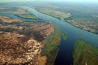
Mouth of the Kwando (left center) into the Zambezi near Kazungula ; Aerial view from the southeast |
||
| Data | ||
| location |
Southern Africa : Zambia Angola Botswana Namibia |
|
| River system | Zambezi | |
| Drain over | Zambezi → Indian Ocean | |
| Headwaters | Bié highlands in Angola | |
| muzzle |
Zambezi Coordinates: 17 ° 47 ′ 32 " S , 25 ° 15 ′ 45" E 17 ° 47 ′ 32 " S , 25 ° 15 ′ 45" E |
|
| Mouth height |
924 m
|
|
| length | 1500 km | |
| Catchment area | 148,994 km² | |
| Outflow A Eo : 148,994 km² at the mouth |
NNQ MNQ MQ Mq MHQ |
14.9 m³ / s 27.3 m³ / s 32.5 m³ / s 0.2 l / (s km²) 35.3 m³ / s |
| Left tributaries | Cocoio, Cussivi | |
| Right tributaries | Cuembo, Capembe, Luiana | |
|
Cuando in the Caprivi Strip (2018) |
||
The Cuando (Angola; there also Kuando ) or Kwando (Botswana, Namibia, Zambia) is a 1500 kilometer long right tributary of the Zambezi in southern Africa . In the lower reaches it is first called Linyanti and finally Chobe .
course
The Cuando rises in the highlands of Bié in Angola and flows towards the southeast. Later the border with Zambia follows him . The Cuando then flows through Namibia's Caprivi Strip near Kongola and forms the border to Botswana on its southern edge . In this section it forms the inland delta of the Linyanti Marshes and then turns abruptly to the east. From here it is called Linyanti and - after passing the temporarily dry Liambezi Lake - Chobe (pronounced: Tschobe ). The river flows into the Zambezi at Kazungula on the border of Botswana, Namibia, Zambia and Zimbabwe.
Linyanti
In the river section called Linyanti , the river basins of the western neighboring river Okavango are in temporary contact. During strong floods, water from the Okavango reaches the Linyanti via the Magwekwana River (also known as the Selinda Gully). Likewise, part of the water flows from the Linyanti over the Savuti into the Mababe Depression when the water level is appropriate . At this point, at the end of the last glacial period, the Linyanti Inland Delta continued south, where it was connected to the Okavango Inland Delta. The stronger sedimentation there and a dune stretching to the east contributed to the fact that the Linyanti overflowed with a sharp change of direction to the east to the Zambezi (see satellite map).
Hydrometry
The alternately humid climate, large evaporation areas in the swamps and water losses in the subsoil cause an unusually even and, in relation to the size of the catchment area, low water flow in the Cuando.
The flow rate of the river was measured in m³ / s at the mouth.

ecology
Mainly because of the high wildlife population, the following national parks, all of which fall within the cross-border Kavango-Zambezi Transfrontier Conservation Area , have been established in the Cuando river basin :
- Luiana Game Reserve (Angola)
- Sioma Ngweizi National Park (Zambia)
- Bwabwata National Park (Namibia)
- Mudumu National Park (Namibia)
- Nkasa Lupala National Park (Namibia)
- Chobe National Park (Botswana)

River history

The Zambezi did not flow into the Mozambique Strait about 65 million years ago . It flowed parallel to the Cuando and Okavango and, like these, emptied into the Limpopo . The Zambezi used the river bed of the Shashe , and the Cuando that of the Motloutse . Although the Luangwa and the Kafue were tributaries of the Zambezi back then, the Kafue was extended by the Chambeshi and it flowed over the Machili valley. Although the Luangwa had a course like today, it did not flow to the east at the current mouth, but flowed to the west, up the current river bed of the Zambezi and flows into the Paleo Zambezi in the border area between Zimbabwe and Botswana.
The uplift of the Ovambo-Kalahari-Zimbabwe Fault (OKZ) created a new watershed that cut off the Zambezi from the Limpopo. As a result, a lake was formed in the Makgadikgadi Basin, the highest shoreline of which was 995 m and which was comparable in extent to today's Lake Victoria , or in some cases significantly larger. A total of 5 different shorelines have been found so far. The lake on today's Zambezi was dammed by the Chobe or Mambova fault . In the further course of the Luangwa changed its course to the east. Then the Chambeshi, which has since been part of the Congo catchment area, fell away . Then the Kafue shifted its course over the Kafue floodplains to its current bed. And finally the Zambezi broke through the faults above the Victoria Falls, so that it no longer flowed into the Makgadikgadi Basin either. As the last, the course of the Cuando was diverted by a sand dune to the Zambezi, although it is still partly in contact with the Okavango.
See also
Web links
Individual evidence
- ^ The World Bank, Water Resources Management, Africa Region: The Zambezi River Basin: A Multi-Sector Investment Opportunities Analysis , Washington 2010
- ^ A b The Zambezi River Basin - A Multi-Sector Investment Opportunities Analysis - Volume 3 State of the Basin
- ↑ A proposed drainage evolution model for Central Africa — Did the Congo flow east?
- ^ A b The evolution and ages of Makgadikgadi paleo-lakes: consilient evidence from Kalahari drainage evolution south-central Africa
- ^ The Zambezi River - Andy E. Moore, Fenton PD (Woody) Cotterill, Mike PL Main and Hugh B. Williams


