Nkasa Rupara National Park
|
Nkasa Rupara National Park
|
|
|
Nkasa Rupara National Park with elephants |
|
| location | Eastern Caprivi Strip , Namibia |
| surface | 320 km² |
| WDPA ID | 30052 |
| Geographical location | 18 ° 24 ' S , 23 ° 46' E |
| Setup date | March 1, 1990 |
| administration | Ministry of Environment and Tourism |
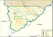
The Nkasa-Rupara National Park ( English Nkasa Rupara National Park ; before that - probably mistakenly - Nkasa Lupala ; until the mid-2000s Mamili National Park (English Mamili National Park )) is a national park and also the largest wetland in Namibia . It lies in the middle between the islands of Nkasa and Lupala (Rupara) in the Kwando River in the central southern corner of the Caprivi Strip .
During the dry season , the islands can be reached via paths in the park, but after rain it is covered by up to 80 percent with water and the islands are cut off from the mainland.
The park has a high density of large African animals, including the elephant .
Since 2016, the park has been on the tentative list of Namibia as part of a proposal to expand the Okavango Delta World Heritage Site in Botswana to include its inflow and peripheral areas in Namibia .
Individual evidence
- ↑ Nkasa Rupara National Park. Nkasa Lupala Lodge. Retrieved October 30, 2014
- ↑ ast-reisen.de: Rainfalls in the Mamili National Park (accessed on March 11, 2009)
- ^ Okavango Delta. In: whc.unesco.org. UNESCO World Heritage Center, accessed June 19, 2017 .


