
Landhausstrasse
| Landhausstrasse | |
|---|---|
|
|
|
 |
|
| New front: British Hotel | |
| Basic data | |
| place | Dresden |
| Borough | Inner old town |
| Created | 14th Century |
| Newly designed | 2008 |
| Hist. Names | Platea Pirnensis (1388), Pyrnissche gasse (1391), Pirnergasse (1410), (inner) Pirnaische Gasse |
| Name received | 1859 |
| Connecting roads | Neumarkt , Pirnaischer Platz |
| Cross streets | Friesengasse (S), Schießgasse (N) |
| Numbering system | reciprocally |
| Buildings | Country house |
| use | |
| User groups | Local traffic , pedestrians , tourists |
| Road design | restoring new buildings (2010s) |
| Technical specifications | |
| Street length | 250 |
The Landhausstraße - until 1859 Internal Pirnaische alley - leads from Neumarkt to Pirnaischer place . It is an inner city street in the center of Dresden and belongs to the inner old town district .
location
Landhausstraße is located in the Altstadt district and is part of the Altstadt I district . It connects the Neumarkt with the Pirnaischer Platz and regained its inner-city importance with the reconstruction of the Frauenkirche and the construction work on Neumarkt around 2010. Cross streets from Neumarkt turn right into Friesengasse and Schießgasse left to the north. In the development of the Neumarkt was on the south side to Moritz Street the development of and up to the back Wilsdruffer road the Quartier IV the formed opposite quarters III to Rampischen road out. The buildings in the extension of the north side into Neumarkt are addressed to this.
history

The road route on the historical tour from Dresden to Pirna was up to the expansion of the urban area in the eastern suburb area at the Church of Our Dear Women . This tour of the early church building probably already existed in the 13th century. The platea Pirnensis is mentioned in 1388, Pyrnisschegasse in 1391 and Pirnergasse in 1410. On the map from 1529 the Pirnische Gasse (24) is in front of the Frauenthor (G) and separates from the Rampschen Gasse (23) to the southeast at Gottesacker (Q) . In 1547 Moritz received the electoral dignity and expanded Dresden as a residential city. He expanded the residential palace , with the relocation of the city fortifications, the Neumarkt was laid out, and in 1550 he incorporated Altendresden . The route to Pirna came within the urban area and in 1591 the Pirna Gate was the destination on the outskirts. In 1760, when Dresden was bombarded during the Seven Years' War , the buildings on Pirnaische Gasse were badly affected, whereupon (as in the surrounding area) they were rebuilt and rebuilt. The buildings on Pirnaische Gasse have belonged to baroque Dresden ever since.
The Pirnaische Gasse extended from the old town into the suburbs on to the Pirnaische Landstrasse. After the Pirnaische Thor was laid down in 1820, it was common to distinguish it as the “inner” Pirnaische Gasse from 1840 onwards. In the 1841 address handbook, “Pirnaische Gasse (Vst.)” With the houses 1–56 on the cadastral areas 1221–1332 and “Pirnaische Gasse (Altst.)” With the houses 1–24 on the cadastral areas 151–165 and 184 –200 differentiated. In addition to the five- and six-storey residential buildings, no. 4 and 5 are listed as the Commungebuilding, house 6 for the Harmoniegesellschaft , house 9 and 11 are listed as the judicial office, on plot 16 is the country house of the Saxon estates . In addition, the address Pirnaischer Platz 1 (suburb) is included with a residential building. On the ground plan from 1855, the Pirnaische Gasse from Neumarkt to Pirnaischer Platz is located, continuing as “outer Pirnaische Gasse”, the Neue Gasse is crossed to the Pirnaischer Schlag . In 1859 the name of the inner (old town) street was changed after the country house built between 1774 and 1775 . Landhausstraße is the current name that still exists. The name outside the old town was "Äussere Pirnaische Straße". In the 1860 address book (p. 314) the street was first recorded as Landhausstraße "from Neumarkt to Pirnaischer Platz" with buildings 1–24. The counting of the plots is then in horseshoe numbering with 1–15 (north side) and back from 16–24 on the country house side. The five-storey residential building 15 with a barber, a trimmings shop and the gold-and-silver shop is the corner house with Schießgasse 1. Likewise, in the 1860 address book, Pirna'sche Strasse in Old Town - Pirnaische Vorstadt is "from Pirnaischer Platz to Pirnaischer Schlag" accepted.
The buildings on Landhausstrasse were affected by the destruction of the city center during the air raid on February 13, 1945 . The country house on the south-west side was heavy and the police headquarters on the north-east side at the corner of Schießgasse was recorded as having been hit with moderate severity. After the damage was repaired, the presidium was used again, while the country house remained in ruins for some time. The other ruins were cleared with the expansion of the east-west thoroughfare and its development at the beginning of the 1950s. With the lack of historical development and the surrounding empty space in the city center, Landhausstrasse lost its importance. The attention had shifted from Neumarkt and Landhausstrasse to the southwest. With plans from the 1950s and 1960s, the central axis of Ernst-Thälmann-Strasse, widened to 61 meters, and the old market with residential and commercial buildings became the city center. The country house, rebuilt at the east end of this main road to Pirnaischer Platz, was made usable as a city museum at the beginning of the 1960s . The wider street led to the loss of the eastern part of the building and the side wing and thus the symmetry of the country house. The property between Schießgasse, Landhausstrasse and Pirnaischem Platz became a side street from Landhausstrasse into Wilsdruffer Strasse.
With the (re) construction of the Frauenkirche and the Neumarkt in the 2000s, the restoring design of Landhausstrasse was started based on historical models and continued towards Pirnaischer Platz.
Outer Pirnaische Strasse
First the Pirnaische Gasse was extended and the route led through the Great Garden with the continuation in Striesen , Gruna and Seidnitz . The continuation of the route as Pirnaische Landstrasse was given the name Bodenbacher Strasse east of the Great Garden after the long-term destination in Bohemia: Bodenbach behind Pirna along the Elbe. The country road took the course through the grounds of the Great Garden, which was built from 1676 at the behest of Elector Johann Georg III. was created. Since 1840, the section in the suburb between Pirnaischer Platz (until 1820 the location of the Pirnaischer Tor ) and the Pirnaischer Schlag ( excise office ) has been named Äussere Pirnaische Gasse . Around 1855 Pirnaische Gasse was located from Neumarkt to Kleine and Große Schießgasse and continued in the area of the ring of Maximilians- / Moritzallee to Johannisgasse / Amalienstraße from Pirnaischer Platz. Then the Äußere Pirnaische Gasse begins and leads (past the Johanniskirche and -kirchhof ) over the Lange / Neue Gasse to the Pirnaische Schlag across the Pirnaische Vorstadt. In 1855 this suburb is bordered by Albrechts Gasse (laid out like an avenue to the south) and the further path (outside the suburb) leads north around the Great Garden. After the renaming of Landhausstraße in 1859, the street name of Pirnaischer Platz remained for the continuing Äußere Pirnaische Straße without the addition of “Äußere”.
With the expansion of the Pirnaische Vorstadt, the Grunaer Straße was created north of the route and south of it Johann-Georgen-Allee (→ Lingnerallee) to the Great Garden (Lennéstraße). The Pirnaische Strasse is built on on both sides and crosses the Katechetenstrasse (only going to the south), the Zinzendorfstrasse / Neue Gasse , Cirkusstrasse (with the Residenztheater) to the Albrechts Gasse (the former place of the Pirnaischer Schlag, → Blüherstrasse ), the other one Lauf is tree-lined and undeveloped up to Lennéstrasse and ends at the western edge of the Great Garden. The eastern section planned in 1900 is not implemented after the First World War , inflation and the global economic crisis , but is built with sports facilities . Since then the area has been called Güntzwiesen , the northern part recently called Cockerwiese. According to the 1940 address book, Pirnaische Strasse runs through the Pirnaische Vorstadt with the houses 1–69 (odd, left side) and 2–60 (even) in the counting from Pirnaischer Platz.
During the bombardment on February 13, 1945 , the buildings along Pirnaische Strasse - like the entire Pirnaische Vorstadt - were completely destroyed. The area was not used after the ruins were cleared and remained green and fallow land, the new housing construction followed the north side of Grunaer Straße. Around 1970 15-story high-rise buildings were added. Pirnaische Strasse was ignored and it disappeared from the city map. With the decision to develop computer technology in the GDR, the section to Pirnaischer Platz was built over. Since the fall of the Wall in 1990, Pirnaische Strasse has been the access road to the parking spaces and the converted Robotron buildings (Pirnaisches Tor office building, Lingnerallee office building). With the construction of the Dorint -Hotel and the commercial complex in the Karree Pirnaische / Blüher- / Grunaer Strasse after the fall of the Wall, the Pirnaische Strasse was partially rebuilt. The southern part is used by the Sächsische Aufbaubank (Pillnitzer Straße 9 / 9a).
Since 1938 the Jewish citizens of Dresden were massively and increasingly restricted and isolated in their freedoms. In the III. A Jewish house was set up on the 1st floor of Pirnaische Strasse 32 . The puppeteer and zookeeper Egon Gäble lived on the second floor at Pirnaische Strasse 18.
Housing stock 1943
The address book 1943/1944, the last one before the destruction in 1945, gives the following property specifications with development.
- Left side:
- Neumarkt to Schießgasse:
- (1) Five-storey residential building, 16 residential units, first floor: bakery
- (3) Five-storey residential building, 12 residential units
- (5) Five-storey residential building with a rear building owned by the state capital Dresden, 1st floor youth welfare office and welfare office, 17 residential units, first floor: Gebr. Hirsch successor
- (7) Town house owned by the state capital Dresden, Eg: 1st district, I. – III. Floor: City Welfare Office (district center), 4th floor two apartments (city inspector, administrative assistant)
- (9) Town house owned by the state capital Dresden, I. – III. Floor: City Welfare Office (district center), side building, ground floor: accommodation for the street cleaning office, 4th floor and garden building 1st floor: two apartments
- (11) 1st floor and owner of the company "Harmonie", first floor: two business rooms, two apartments, I, III, IV floor: seven apartments / side building on the right: plumber's workshop on the first floor, first floor: company “ Harmony ", III. Floor: two apartments / side building on the left: first floor: hardware store, 1st floor: company "Harmonie", II. And III .: four apartments / rear building: two business rooms, one classroom
- (13) five-storey, 1st floor: club hall of the Dresden men's choir and the Schlaraffia association as well as an apartment, II. – IV .: six apartments / back building III. and IV. four apartments / backyard: factory
- (15) six-storey residential building, 13 apartments, first floor: drug dealership
- (17) Owner: The State, to the police headquarters at Schießgasse 7
- (19) - (25): failed (worn away)
- Schießgasse to Pirnaischer Platz
- (27): The owner is Kurt Herzog in London, five storeys, first floor: seven business rooms (groceries, oven shop, large laundry, merchant, dining hall, hairdresser, goldsmith, furrier), I. – IV .: 16 apartments, including two law firms
- Neumarkt to Schießgasse:
- right side
- Neumarkt to Friesengasse
- (2): six-storey residential building, 1st floor: apartment with tailcoat rental, II. – V .: six apartments
- (4): six-storey house, first floor: master locksmith, I.–V. Floor: 15 apartments
- (6): five-storey house owned by the Actienbrauerei zum Löwenbräu (Munich), Eg: business premises, 1st floor: Preuss. Landwehr Office Casino, National Club of Saxony, 2nd floor: business premises, III. 1st and 4th floor: four apartments
- (8): six-storey residential and commercial building, Eg. 1st and 1st floor: two business rooms, a workshop, II. – V .: 19 apartments
- (10): six-storey residential building, Eg. and I. floor: men's clothing store and bespoke tailoring (business premises), II.–V. Floor: four apartments
- (12): Building of the District President Dresden-Bautzen and the District Administrator Dresden owned by the State of Saxony (country house)
- Main entrance: König-Johann-Straße 23
- Entrance Friesengasse 6: Eg: Landesplanungsgemeinschaft Sachsen (district office Dresden), Eg – IV: The District President, 4th floor apartment of the property manager
- Entrance Friesengasse 4: 4th floor: two apartments
- Entrance Schießgasse 6: Eg .: two business rooms (hairdresser, merchant), Eg.–IV. The district administrator, 1st floor: Insurance Office for Employees Insurance, 3rd floor: The Landesjägermeister, 4th floor: Apartment
- (14) and (16): fail
- Schießgasse to Pirnaischer Platz
- (18): five-storey residential building owned by the construction company for the residential city of Dresden, Eg. 1st and 1st floor: Albert Rehfeld business premises, II.–IV. Floor: four apartments
- Neumarkt to Friesengasse
Development
- Land on Landhausstrasse at Neumarkt

Landhaus vom Pirnaischen Platz, on the right Landhausstrasse
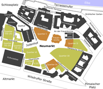
Streets and quarters of Neumarkt (new development)

Neumarkt and Altmarkt around 1895
View from the Frauenkirche
Neumarkt to the entrance of Landhausstrasse


- Reussisches Haus: The Reussisches Haus was located at Landhausstrasse 6. Until after 1900 the “Britischer Hof” restaurant was located in the house. After the change of ownership, initially to a beer wholesaler, the "Löwenbräu" restaurant was located there.
- Society Harmonie (Landhausstraße 11): Society Harmonie was founded on February 20, 1786 as a club for the educated middle class and in 1800 took the name Harmonie . Originally the association was intended for no more than 100 members, the number of members grew significantly later. In 1862 there were 275 civil servants, artists and scientists in the society. Poor students were welcomed as extraordinary members as well as foreign guests. Two students were given free meals at a time . In addition to entertainment events, cultural events and science evenings were also organized. The company initially rented rooms in Plauenschen Gasse. In 1830 the company acquired the Palais Hoym in Landhausstrasse. They later owned a casino near the Dreikönigskirche.
- Württembergisches Palais (Landhausstrasse 15): Ursula Katharina Countess Lubomirska (November 25, 1680 - May 1743 Leitmeritz) was a mistress of Augustus the Strong. She was married to the Crown Chamberlain Lubomirski. In 1704 she gave birth to August's son Johann Georg (Chevalier de Saxe) and shortly afterwards was made Princess of Teschen. From 1704 to 1705 her apartment was located at what would later become Landhausstrasse 15. In 1722 she married the Duke of Württemberg, after which she lived in the Württemberg palace on Innere Pirnaische Gasse, and her summer residence was on Friedrichstrasse. In 1756 she sold the summer residence to Minister Heinrich von Brühl.
South side

When Neumarkt was redesigned at the beginning of the 21st century, Quartier IV was created between Landhausstrasse and Moritzgasse / back of Wilsdruffer Strasse and new buildings adapted to the history were built on.
- Landhausstraße 2: Next to the Neumarkt 1 shopping center is the “Frauenkirche / Neumarkt multi-storey car park” with 412 parking spaces. On October 23, 2004 the foundation stone was laid for the quarter at the Frauenkirche , the first quarter of the rebuilding of the Neumarkt in Dresden. Products from manufacturers of international luxury brands are offered.

- House Landhausstrasse 4 : On March 24, 1763, the house, which had burned down in the Seven Years' War, was bought by the wine merchant Gottlob Julius Grumpelt and a rococo house was built. The house, which was destroyed in World War II, was reconstructed true to the original.
- Landhausstrasse 6 (down to Moritzstrasse): British Hotel in Quartier IV / 2 (holiday apartments). The reconstruction took place in 2008-2010 for the investor Swiss public limited company Hapimag. The former Beichlingsche Palais belongs to Quartier IV / 2 and connects to the Baywobau-Quartier Hotel de Saxe. For the reconstruction of this building, many individual parts were salvaged from the ruins after 1945 for later reconstruction. The seven-axis Beichling Palace was built for the chief falcon master and chamberlain, Count Wolfgang Dietrich von Beichlingen, until 1715. Together with the Palais de Saxe, the building was built by George Haase and George Bähr and, after being destroyed in 1760 when Dresden was bombarded during the Seven Years' War, rebuilt without any major changes. The property of the Palais de Saxe lies in the depths on Moritzgasse. It borders on the residential buildings of the "Szegedhaus" (after the Hungarian nationality restaurant "Szeged" at Wilsdruffer Straße 4 ) and this location means that construction in the perspective period is impossible, so there is a green area here.


_14_212_4_Das_St%C3%A4ndehaus_in_Dresden.PNG)
- Quartier IV / 3 (Frieseneck) Landhausstrasse / Friesengasse: A design statute G-12 was drawn up for this penultimate free plot of land on Neumarkt. Previously, “[...] a small-scale mixed use of retail and catering, offices and apartments. A building with the historical facade of the former buildings is to be planned on the property at Landhausstrasse 8. [...] The new corner building at Landhausstraße 10 will not be a reconstruction, but the building plan calls for the restoration of the cubature. "
- Landhausstraße 8: The »Frieseneck« offers comfortable living space on six floors with high-quality furnishings.
- Landhausstrasse 10: The properties at Landhausstrasse 8 and 10 and Friesengasse 5 and 7 are located directly between the baroque Landhaus and the British Hotel, one of the most important palaces in the city.
- Landhausstrasse 12: The corner house at Landhausstrasse 12 was not intended to be built in accordance with the urban planning and design concept for Neumarkt from 1996/2001.
- Landhaus (Landhausstraße 14/16): The former Saxon parliament building (seat of the estates) became strong from 1770 to 1775 as a country and wheelhouse according to designs by the court architect Friedrich August Krubsacius in the late Dresden Baroque style on the site of the 1760 during the bombing in the Seven Years War destroyed Palais Flemming-Sulkowski built. The Landhaus is addressed at Wilsdruffer Strasse 2, another entrance is on Landhausstrasse (unnumbered). It houses the city museum , the city gallery and the administration of the museums of the city of Dresden . The splendid side of the country house visible at the east end of the east-west main road to Pirnaischer Platz was made usable again as a city museum at the beginning of the 1960s. An eastern side wing was lost due to the widened Wilsdruffer Straße, the western counterpart on Friesengasse was retained and is used by the Saxon Homeland Security Association. In 2005 and 2006 the building was renovated and, in accordance with the building regulations, a steel escape staircase was added to the gable end of the country house facing Pirnaischer Platz. The Dresden vernacular invented the term "Reuse".

North side
With the new development of the Neumarkt, Quartier III was formed between Landhausstraße and Rampischer Straße and built on with buildings adapted to the historical model.

- Landhausstrasse 1: The eastern part of the house at Neumarkt 7 / Landhausstrasse 1 was built as a new building with a partial facade reconstruction from 2007/2008 at the location of the houses Neumarkt 7, Trier-Saulsches Haus and Landhausstrasse 1, which were destroyed in the war in 1945 .
- Landhausstraße 11: Palais Hoym (Palais Riesch, later the Harmonie building ) was an early classical palace in Dresden. It was located at Innere Pirnaischen Gasse 6, which later became Landhausstrasse 11.
- Landhausstrasse 13: Formerly the home of the architect Johann Georg Starcke , which he rebuilt around 1686. The house burned down in 1760 as a result of artillery fire.
- Landhausstraße 15: The Soli-Deo-Gloria-Haus , a baroque house after 1767, was built on this property . The previous building from the mid-1750s was destroyed in the Seven Years War. It was totally destroyed in the air raid on February 13th.
- House Landhausstraße 25 : The baroque residential building stood on the corner of Kleine Schießgasse and was demolished in 1895 for the construction of the police building.
literature
- Stefan Hertzig : The late Baroque town house in Dresden 1738–1790 . Gesellschaft Historischer Neumarkt Dresden , Dresden 2007, ISBN 3-9807739-4-9 , p. 125-128 .
Web links
- Architecture discussion - Gesellschaft Historischer Neumarkt Dresden e. V.
- Dresdner Strasse 1813 in the Stadtwiki Dresden
Individual evidence
- ↑ a b Landhausstrasse. In: Stadtwiki Dresden. Retrieved September 15, 2019 .
- ↑ a b c d Damage plan of the city of Dresden. Edited in 1945/1946 by the Dresden City Building Authority using the basic map: Plan of Dresden. Sheet 1 [Old Town, New Town, with legend on the degree of destruction]
- ^ Dresden address calendar 1837 : Pirnaische Gasse
- ↑ Royal. Saxon licensed Dresden address calendar 1839
- ^ The entry in the Dresden address handbook 1840 : Pirnaische Gasse, Before the Pirnaischer Schlag, Pirnaischer Platz. In the Dresdner Adress-Handbuch 1841 the Pirnaische Gasse (old town) and Pirnaische Gasse (suburb) are included on page 318, as well as Pirnaische Platz (old town).
- ↑ City map of Dresden, 1:20 000, lithograph, around 1855 at the Deutsche Fotothek
- ^ Adolf Hantzsch : Name book of the streets and squares of Dresden (= messages of the Society for the History of Dresden . No. 17, 18 ). Wilhelm Baensch, Dresden 1905, p. 81 ( digitized version ).
- ^ Address manual for the residence city of Dresden 1848 . Fourth section. List of all streets and squares, the houses together with their owners and (independent) residents, the streets and cataster numbers, the indication of the jurisdiction and the tax units on the property : Äußere Pirnaische Gasse in the Pirnaische Vorstadt (p. 299– 302): 1–5: residential buildings, 6: Commungebuilding “The Bohemian parish rectory”, 7–33: residential buildings, 34: state building: Former Accishaus on the ground floor with the Thor-Contr. Hänisch, 35–46: Residential houses, 47: Commungebuilding: Catechetenwohnung, 48–56: Residential buildings // Inner Pirnaische Gasse in the old town (p. 302): apart from the residential houses there are special buildings: 4 and 5: Commungebuilding (also Bureau of the Communalgarden Committee ), 6: Harmoniegesellschaft, state building - 9: Justice Department II. Department, 11: Justice Department I. Department, 16: Country House. In addition, on the ground floor of house 1: wine shop, 2: watchmaker and lottery collector, house 3: baker, house 6: porcelain shop, house 7: jeweler and wine shop, house 10: an exchange office of the Banquier Bondi, from house 12: a hat maker and a glove maker, at 13: Italian goods store, house 14: ribbon and thread dealer, at 15: antiquarian book and art store, at 21: agency of the hail damage insurance institute in Leipzig, at 22 the "Englische Hof"
- ^ In the 1860 address book from Pirnaischer Platz to Pirnaischer Schlag
- ↑ Address and business manual of the royal capital and residence city of Dresden 1860 . Section II. Proof of occupancy of the houses in alphabetical order of the streets, p. 314/315.
- ↑ House 1: four-story building on Neumarkt with a hairdresser, hat maker and merchant on the ground floor / 2: five-story residential building / 3: five-story residential building with three-story back building / 4 and 5 are five-story community buildings / 6: the Harmonie-Gesellschaft owns a four-story building with a back building / 7: four-storey building with rear building / 8: six-storey house with a guest room on the ground floor and the expedition of the K. Public Prosecutor's Office / 9: State building with the Kgl. District court of the 1st abb., With the detention house inspector and his assistant, a househusband and five prison guards, on the fourth floor the constables / 10: five-storey house of the banker Bondi and his office on the ground floor, apartments on the third floor. and IV. Floor / 11: State building with the Kgl. District Court of the 2nd and 3rd Abth. with the office building administration in the Eg. / 12–14: five-storey residential buildings / 15: five-storey, corner of Schießgasse / 16: state building: country house, with state debt coffers and bookkeeping, K. Fire Insurance Commission, K. Landrentenbank and old age pension bank administration, in the III. The archivist and attendant live on the 1st floor / 17: five-storey house of the Chamber of Accounts on the 2nd floor and apartments / 18: five-storey residential building with business on the ground floor / 19: five-storey residential building with business premises on the ground floor and cigar shop / 20: five-storey business premises of the bar and restaurant lives on the first floor / 21: six-storey, owned by the concursion property of the hotelier Adolph, shoemaker sales local / 22: British Hotel - Zum Engl. Courtyard, property like 21/23: five-storey, on the ground floor of the Dreschsler's shop from III. Floor / 24: together with the adjacent Neumarkt 8 belongs to the pharmacist Richter, on the ground floor the shop of the shoemaker Pöthe from the fourth floor
- ^ Homepage of the Dresden City Museum
- ↑ Landhausstraße to Wilsdruffer Straße on openstreetmap
- ↑ For example, Address Book for Dresden and its suburbs . S 365: Pirnaische Landstrasse in the suburb of Striesen-Gruna, from Stübelallee to the city limits of Gruna, left side undeveloped, right side the plots 6–16 (cadastral department Striesen), of which 8 and 10: two-storey with side building, 12: owner the Municipality for collecting indirect municipal taxes, resident is tax collector Curt Bolling, on 14 a construction site, for 16 two builders / architects are owners.
- ^ Bodenbacher Strasse. In: Stadtwiki Dresden. Retrieved September 15, 2019 .
- ↑ Dresden.-1: 20,000. - p. L., Around 1855, monochrome. Lithograph With lines of the Leipzig-Dresden Railway
- ^ Plan of Dresden. 1900. Arranged by the land surveying office of the city of Dresden. (Gerke 4th edition 1:10 000). Dresden Schönfeld 1900.
- ^ Address book for Dresden and suburbs . Year of publication 1920 Part three. House book.
- ↑ a b plan of Dresden . Supplement to the Dresden address book - as of July 1943. - 1:20 000.
- ↑ see also the aerial photo from 1943 under Google earth, coordinates: 51 ° 2 '48 N / 13 ° 44' 50 E
- ↑ Address book of the state capital Dresden, Freital-Radebeul, with surrounding 6 cities and 24 communities. P. 607 to 610. Plan of Dresden and the surrounding area 1940 : Pirnaische Straße v. Pirnaischen Platz zd Albrechtstraße / left side (north): 1–69: four to five-storey residential buildings, some with back buildings, including: in 3: Radeberger Exportbierbrauerei AG as owner, 17: jersey store, lingerie factory and master optician on the first floor, 29: concert - and entertainment establishment "Palmgarten", 59 owned by the city of Dresden. // Right side: 2–60: three- to six-storey residential buildings partly. with rear building, including in 2: Neue Gothaer Mutual Life Insurance Bank as owner, 16: through house to Katechetenstraße 1 with three wings (B, C, D), 16 and 18 owned by Wekate sewing machine parts Ges.mbH, 22 and 30 is canceled, Owner of house 32 Internationaler Verein z. Combating the scientific. Animal torture in liquidation, in the back building 48 the large garage Albrechtstrasse. // Cross streets are: Katechetenstraße (22/23), Neue Gasse between 30/32 and 29/31, Zirkusstraße (40/42 and 45/47), Albrechtstraße (60 and 69)
- ^ Sächsische Aufbaubank - Förderbank - Pirnaische Straße 9
- ^ Lewin Chaim: Obituary Report, Ghetto Theresienstadt. In: holocaust.cz. Retrieved September 15, 2019 .
- ^ Address books of the state capital Dresden: 1934, p. 189; 1941, p. 201; 1943/44, p. 204
- ↑ Address book of the district and state capital Dresden, Freital-Radebeul, with surrounding ... , year of publication 1943
- ↑ for comparison also address book for Dresden and its suburbs 1900 . Print from December 1899 to June 3, 1900.
- ↑ There were bypasses in the city center for road traffic and new passageways past Neumarkt.
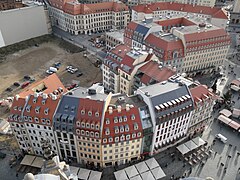
- ↑ December 2009: Overview from the viewing platform of the Frauenkirche over Quarters III (front) and IV of the Neumarkt area on Landhausstrasse with An der Frauenkirche 16 (Quartier III, first building from left) and Landhausstrasse 6 ("British Hotel", Quartier IV, under construction), behind the country house (left of the "British Hotel")
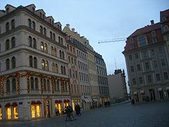
- ↑ November 2009: Quartier III of the Neumarkt area: on the left the corner building Neumarkt 4 with a reconstructed but unhistorically doubled facade to the right, next to it the left part of the house Neumarkt 6 and Neumarkt 7, right part of the house Neumarkt 6 and Landhausstrasse 1, as well as the still undeveloped part of the quarter to the back wall of the police headquarters; on the right the facade reconstruction of the Salomonisapotheke belonging to Quartier IV (Neumarkt 8)
- ^ Address book Dresden and its suburbs, 1907 . Page 348
- ^ Address book for Dresden and suburbs 1920 . Page 337
- ^ Artur Brabant (royal archivist in Dresden, editor): German battlefields. Events and hiking trips . Volume 3, Dresden 1913, p. 393
- ↑ Franz coupling Ellfeld: The establishment of harmony 1786 .
- ^ Rudolf Mothes: Memoirs of a Leipzig lawyer (Part A)
- ↑ Adolf Hantzsch: Outstanding personalities in Dresden and their apartments (= communications from the Association for the History of Dresden . No. 25 ). Wilhelm Baensch, Dresden 1918, p. 41 f . ( Digitized version ).
- ↑ dresden-online.de: parking spaces in the city center
- ↑ Shopping area at the Frauenkirche
- ^ Stefan Hertzig: The baroque Dresden. Michael Imhof Verlag, 2012, ISBN 978-3-86568-833-0 , pp. 282/284 with Fig. 238 [Landhausstrasse 4].
- ^ British Hôtel - Quartier IV / 2. Gesellschaft Historischer Neumarkt Dresden , accessed on September 15, 2019 .
- ↑ “Szegedhaus” Wilsdruffer Street. In: das-neue-dresden.de :. Retrieved September 15, 2019 .
- ↑ Pictures of the construction work at Landhausstraße / Friesengasse ( Memento from February 21, 2016 in the Internet Archive )
- ↑ Design statute G-12 Landhausstrasse 6-8 (British Hotel). (PDF; 1.6 MB) State capital Dresden, October 29, 2008, accessed on September 15, 2019 .
- ↑ a b Quartier IV / 3rd Society Historischer Neumarkt Dresden, accessed on September 15, 2019 .
- ↑ Luxurious living in the splendor of the Dresden Frauenkirche , Object Dresden Frieseneck GmbH & Co. KG, Munich
- ^ Homepage of the Dresden City Museum
- ↑ country house. In: Stadtwiki Dresden. Retrieved September 15, 2019 .
Remarks
- ↑ see Moritzstraße 6 . For 1840 Moritzstrasse from Neumarkt to Grosse Schießgasse and Gewandhausplatz is listed with houses 1–23. House 1 belongs to Neumarkt 8. The 1900 address book names Moritzstrasse from Neumarkt to Johann-Georgen-Allee. Houses 1–21 (odd) with Friesengasse (5 to 7), König-Johann-Straße (11 to 13), Schießgasse (15 to 17), Maximilians-Allee (19 to 21) are on the left side. On the right side are 2–20 (straight) me the side street König-Johann-Straße (8 to 8b), Gewandhausstraße (18 to 20). The buildings on Moritzstrasse were totally destroyed in 1945 and the corner house at Neumarkt was badly destroyed. When Ernst-Thälmann-Straße is being built, it will become a residual route behind the “Szegedhaus” ( Wilsdruffer Straße 4 ).
- ↑ The name "Cockerwiese" has existed since 2016, after having been colloquial since Joe Cocker's concert on June 2nd, 1988.
- ↑ “The courtyard area between the existing residential development and the new development to be built can be purchased at a price of 260,000 euros in order to partially support it with a single-storey underground car park. In this case, the surface must be restored to its existing functions as a green inner courtyard. ”From Exposé Neumarkt Q4 17th September 2010
Coordinates: 51 ° 3 ′ 1.8 ″ N , 13 ° 44 ′ 32.9 ″ E