Apple mountain
|
Apple Mountain (Former parish) village Apfelberg, Landschach Sdlg Cadastral community Apfelberg |
||
|---|---|---|
|
|
||
| Basic data | ||
| Pole. District , state | Murtal (MT), Styria | |
| Judicial district | Judenburg | |
| Coordinates | 47 ° 12 '1 " N , 14 ° 50' 1" E | |
| height | 625 m above sea level A. | |
| Residents of the village | 1145 (January 1, 2014) | |
| Building status | 284 (2001 ) | |
| Area d. KG | 9.33 km² | |
| Post Code | 8720 | |
| prefix | + 43/3512 | |
| Statistical identification | ||
| Community code | 62041 | |
| Locality code | 15357, 15358 | |
| Cadastral parish number | 65101 | |
| Counting district / district | Apple Berg (62041 009) | |
 Location of the former municipality in the Murtal district |
||
| Independent municipality until the end of 2014 Source: STAT : Local directory ; BEV : GEONAM ; GIS-Stmk |
||
Apfelberg was a municipality with 1145 inhabitants (as of October 31, 2013) in the Murtal district and the judicial district of Judenburg in Styria . Since 2015 it has been merged with the municipality of Knittelfeld as part of the Styrian municipal structural reform , the new municipality continues to use the name "Knittelfeld".
geography
Geographical location
Apfelberg lies at the northern foot of the 818 m high Gmeinberg. The area extends from the southern edge of the city of Knittelfeld over the Aichfeld with the village of Landschach to the foothills of the Gleinalpe in the south. The lowest point is at 630 m on the Mur , the highest point at 1178 m .
Community structure
The municipality comprised the following two localities (population in brackets as of January 1, 2020):
- Apple Mountain (218)
- Land Chess (928)
The community consisted of the only cadastral community Apfelberg.
Neighboring communities by the end of 2014
| Spielberg near Knittelfeld | Knittelfeld | Sankt Margarethen near Knittelfeld |
| Spielberg near Knittelfeld , Großlobming |

|
Rachau |
| Grand lobbying | Petty lobming | Petty lobming |
history
The Apfelberg volunteer fire brigade was founded in 1925.
population
According to the 2001 census, the community had 1,086 inhabitants. 97.8% of the population have Austrian citizenship. 75.0% of the population profess to the Roman Catholic Church, 4.3% to the Protestant Church, 17.4% are without religious belief.
politics
The local council consisted of 15 members and, since the local council election in 2010, has consisted of mandataries from the following parties:
The SPÖ provided the mayor in Karl Bacher.
coat of arms
Blazon (coat of arms description):
- "In the silver shield with growing pinned blue tip in the three-pass, lilies bursting out in confused colors."
The municipal coat of arms was awarded with effect from July 1, 1981.
Culture and sights
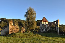
In Apfelberg there is the Einödhof ruin, a former defense yard.
Economy and Infrastructure
According to the 2001 census of workplaces , there were 30 workplaces with 206 employees in the municipality as well as 400 out-commuters and 151 in-commuters. There were 25 agricultural and forestry holdings (13 of them in the main occupation), which together farmed 878 hectares (1999).
There is an elementary school in Landschach.
The traffic development takes place via Möbersdorferstraße L 543.
Personalities
Honorary citizen
- 1989 Hans Gross (1930–1992), Deputy Governor
- 2014 Karl Bacher (* 1955), Mayor of Apfelberg
Individual evidence
- ↑ Province of Styria: Final population status on October 31, 2013 ( Memento of the original from April 15, 2015 in the Internet Archive ) Info: The archive link has been inserted automatically and has not yet been checked. Please check the original and archive link according to the instructions and then remove this notice. (Excel file, 85 kB; accessed on May 2, 2015)
- ^ Announcement of the Styrian state government of November 14, 2013 on the unification of the municipality of Knittelfeld and the municipality of Apfelberg, both political districts of Murtal. Styrian Provincial Law Gazette of December 2, 2013. No. 144, 34th issue. ZDB ID 705127-x . P. 673.
- ^ The State of Styria: The new municipal structure of Styria. (No longer available online.) Archived from the original on December 15, 2013 ; Retrieved November 10, 2013 . Info: The archive link was inserted automatically and has not yet been checked. Please check the original and archive link according to the instructions and then remove this notice.
- ↑ Statistics Austria: Population on January 1st, 2020 by locality (area status on January 1st, 2020) , ( CSV )
- ↑ Communications from the Styrian State Archives 32, 1982, p. 32.


