
Hamburg-Langenbek
|
district of Hamburg |
|
|---|---|
  |
|
| Coordinates | 53 ° 26 '14 " N , 9 ° 59' 10" E |
| surface | 0.8 km² |
| Residents | 4038 (Dec. 31, 2019) |
| Population density | 5048 inhabitants / km² |
| Post Code | 21079 |
| prefix | 040 |
| district | Harburg |
| Source: Statistical Office for Hamburg and Schleswig-Holstein | |
Langenbek ( Low German : Langenbeek ) is a Hamburg district in the Harburg district . With an area of 0.838 km², Langenbek is the fourth smallest district in Hamburg after Sternschanze , Hoheluft- East and Hoheluft-West .
geography
Neighboring districts
Langenbek borders in the north on Wilstorf , in the east on Rönneburg , in the south on Sinstorf and - separated by the Engelbek - in the west on Marmstorf .
history

The name Langenbek is derived from a long stream . There was a courtyard with a water mill by this brook, which was first mentioned in 1306. This courtyard is the origin of Langenbeck. In the middle of the 19th century Langenbek became an independent municipality in the Prussian district of Harburg . In 1937 it was connected to Hamburg as part of the Greater Hamburg Act . In the 1950s, intensive development began on terraced houses on newly created ring roads with names of well-known places in the Lüneburg Heath (e.g. Walsroder Ring, Wilseder Ring). The Langenbeker Feld development area was built from 1987 to 1994.
statistics
- Minor quota: 15.5% [Hamburg average: 16.3% (2017)].
- Elderly rate: 22.9% [Hamburg average: 18.2% (2017)].
- Proportion of foreigners: 10.6% [Hamburg average: 17.1% (2017)].
- Unemployment rate: 3.9% [Hamburg average: 5.2% (2017)].
The average income per taxpayer in Langenbek is 34,231 euros annually (2013), the Hamburg average is 39,054 euros.
politics
The 2015 state elections for the Hamburg citizenship , in which Langenbek belongs to the Harburg constituency , brought the following results in the district:
- SPD 51.1% (-3.6)
- CDU 16.2% (-5.8)
- AfD 10.2% (+10.2)
- Green 7.6% (+0.4)
- Left 7.1% (+1.9)
- FDP 5.3% (± 0.0)
- Other 2.5% (–3.1)
Culture and sights
In the Langenbek district there is a burial mound from the Bronze Age . The grave is located on a hill in a beech grove between Blättnerring and Buchholzer Weg and was discovered in the 1950s. In 1999 this archaeological monument of prehistoric times was added to the list of monuments.
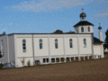
The Syrian Orthodox Church, St. Maria & St. Simona is not in Langenbek, but in Sinstorf, 70 meters south of the Langenbek district boundary.
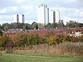
Settlement in Langenbek, behind it high-rise buildings in Wilstorf

Tumulus

Row house development Walsroder Ring 1977
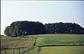
Beech grove "Riege-Holz" 1964


traffic
Langenbek's road connection is via Winsener Strasse, which was a section of Bundesstrasse 4 until the early 2000s . Winsener Straße is practically the only thoroughfare in the district, otherwise residential streets take over the accessibility of the residential areas.
Langenbek is also well connected by public transport . Seven bus routes run through Winsener Strasse, including a Metrobus route and a night bus route. The Langenbeker Feld has been linked by four bus routes since 2001, one of which is a night bus route. These lines undertake branch trips from Winsener Strasse to the new development area.
Others
The Langenbek cemetery is already in the area of Hamburg-Sinstorf.
See also
literature
- From Altona to Zollenspieker. The Haspa manual for all districts of the Hanseatic city , Hoffmann and Campe, Hamburg 2001. ISBN 3-455-11333-8 . Article about Langenbek.
Web links
- District statistics (PDF; 3.4 MB) of all Hamburg districts (as of 2010)
Individual evidence
- ↑ Quota of minors in the Hamburg districts in 2017
- ↑ Proportion of 65-year-olds and older in the Hamburg districts in 2017
- ↑ Proportion of foreigners in the Hamburg districts in 2017
- ↑ Unemployment rate in the Hamburg districts in 2017
- ↑ Statistical Office for Hamburg and Schleswig-Holstein (ed.): Hamburg District Profile 2016 (= NORD.regional . Volume 19 ). 2018, ISSN 1863-9518 ( Online PDF 6.6 MB [accessed February 12, 2018]).
- ↑ Final result of the 2015 general election .
Altenwerder | Cranz | Eißendorf | Francop | Well moor | Harburg | House break | Heimfeld | Langenbek | Marble peat | Moorburg | Neuenfelde | Neugraben-Fischbek | New territory | Rönneburg | Sinstorf | Wilstorf