
Larchkopf (Tux Alps)
| Larch head | ||
|---|---|---|
 The Larchkopf (right) with Schlitters |
||
| height | 1375 m above sea level A. | |
| location | at Strass in the Zillertal | |
| Mountains | Tux Alps | |
| Dominance | 0.42 km → Reiterkopf | |
| Notch height | 29 m ↓ notch to the rider's head | |
| Coordinates | 47 ° 22 '41 " N , 11 ° 48' 58" E | |
|
||

The Larchkopf (older also Lerchkopf ) is 1375 m above sea level. A. high mountain near Strass in the Zillertal at the exit of the Zillertal into the Lower Inn Valley in North Tyrol .
location
The mountain belongs to the northeast ridge of the Tux Alps, which stretches over Gilfert and Kellerjoch to Strass, and forms its last prominent summit towards the Inn Valley. The ridge splits at the Kellerjoch, with one train to the Larchkopf north of the Oxlbach with its long valley, and one south to the Sonnkogel ( 1,439 m above sea level ) via Schlitters in the Zillertal. The ridge of the Larchkopf runs northeast in the rock of Maria Brettfall over rhinestones and knots . To the east lie Schlittersberg and Schlitters at the foot. To the north-west of the Inn are Maurach and Rotholz , with the Rottenburg and Raffl ruins above. Except for the valley shoulders of Raffl and Schlittersberg, the mountain slopes down to Inn and Zillertal in steeper forests, crags and walls. The entire north and east flank of the mountain is the catchment area of the Strasser Giessen .
The summit is in the Schlitters municipal area , the Strass municipal boundary runs directly below on the inside, and after 300 meters it meets the Buch municipal boundary .
Geology and mining
The Larchkopf – Brettfall spur, like the entire right side of the Inn Valley of the Tux Prealps and the Kelchsauer Alps from Schwaz to Brixlegg, consists of Schwaz dolomite ( Lower Devonian, around 400–350 million years) and Wildschönau slate ( Ordovician , Silurian to Lower Carboniferous , around 500–400 Million years). These formations form the Schwaz – Brixlegg mining region , one of the most important copper deposits in the Alps. The pale ore found , here the mercury-containing black gray , lies in the dolomite. The slate forms the valley terraces. The foot of the Inn valley is already made up of calcareous alpine layers: Hochfilzen Formation , Alpine Buntsandstein and Reichenhall Formation ( Permian to Anise , 300–250 million years) with scattered Rauhwacke dolomite breccia (Unteranis, 240 million years).
Northwest of the summit was at 1439 m above sea level. A. Found a prehistoric mining site. It is a fire-driven dismantling , also north of the Rafflhöfe at 940 m above sea level. A. there are old signs of degradation. Old pings can be seen everywhere here. A more recent historical mining is then the Martinstollen at the Weißen Schrofen below the summit. Sites for minerals stretch to Schlittererberg.
The Brettfall tunnel of the Zillertalstrasse (bypass Strass) passes under the Brettfall rock .
Transmitter Jenbach 2 Larchkopf
At the summit there is a transmitter, Jenbach 2 Larchkopf, which serves the Schwaz / Jenbach area and the anterior Zillertal. Broadcast Life Radio (Tirol) and Radio U1 Tirol .
This smaller radio station should not be confused with the more important directional radio station Larchkopf (Gerlos 2 Gerlosberg) on Hainzenberg near Zell.
ways
The mountain is an easy walking to moderately difficult hiking area. It is possible to continue on the ridge via the Rodaunalm or the Ortner chapel and on to the Lackenhütte, where you then come across the ascent from Obertroi to the Kellerjoch.
Individual evidence
-
↑ Max Perger, Wolfgang Ingenhaeff (Ed.): Strass im Zillertal. Verlag Berenkamp, 1995, ISBN 978-385093051-2 , p. 34;
so also in Leopold Weber: Handbook of the deposits of ores, industrial minerals and energy raw materials of Austria: Explanations of the metallogenetic map of Austria 1: 500 000 including the industrial minerals and energy raw materials , Volume 2, Geologische Bundesanstalt, 1997, p. 1254. -
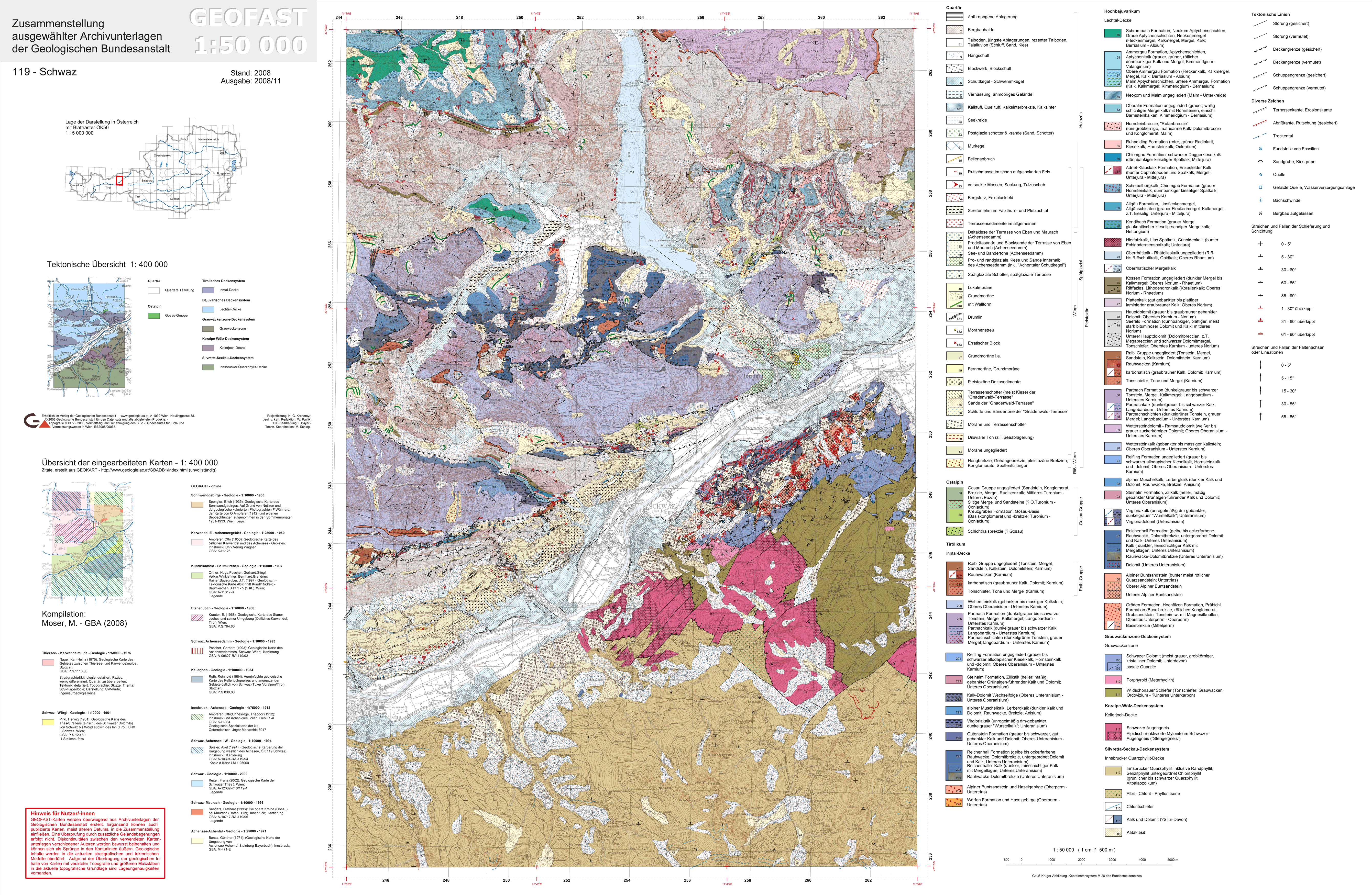
↑ Geofast card GKÖ 1: 50,000, sheet 119, Schwaz (geologie.ac.at);
Fahlerz & Co. ( Memento of the original dated May 30, 2015 in the Internet Archive ) Info: The archive link was inserted automatically and has not yet been checked. Please check the original and archive link according to the instructions and then remove this notice. silberbergwerk.at. -
↑ Brigitte Rieser, Hanspeter Schrattenthaler: Prehistoric copper mining in the Schwaz-Brixlegg area, Tyrol. In: Archaeologia austriaca 82–83 (vol. 1998/99), p. 147 f (whole article p. 135–179);
same: Prehistoric mining in the Schwaz - Brixlegg area: traces of prehistoric mining, tool finds, experiments, minerals. Edition Tirol, 2002, ISBN 978-385361081-7 , p. 55 f, especially Fig. 65; -
↑ G. Schnorrer, R. Poeverlein: Schwaz-Brixlegger discovery sites: 5. The minerals of the Martinstollen at the Weißen Schrofen near Schwaz in Tyrol - as well as Leogangit, a new connection from the Tyrolean mining area. In: Aufschluss , Vol. 58, No. 1 (2007), pp. 27–40;
Martinstollen. mineralienatlas.de (updated entries). - ↑ Schlitters. mineralienatlas.de.
- ↑ BMVIT: senderkataster.at (information after zooming in, status 6/2015).
-
↑ radio rail center , this has been realized in the 1970's as a fully intra-Austrian route, and the transmitter Larchstein / Hainzenberg aimed as a connection to the radio relay rail West 1 on the transmitter Kanzelkehre at the Achenseestrasse in the valley opposite;
cf. on this radio station in Austria: Between Schwaz and Wörgl, Tyrol, images of Jenbach-Kanzelkehre , on wabweb.net (accessed June 3, 2014). - ↑ cf. Maria Brettfall - Rafflgatterl - old mine - Larchkopf - Schlitterberg - to Strass via Maria Brettfall or Schlitters, walking time: approx. 5 hours. Tour description on bergfex.at.