Laurentine watershed

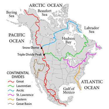
The Laurentine Watershed or Northern Watershed is a continental watershed in North America that separates the direction of flow of waters in eastern and southern Canada from that of the northern Midwestern United States. It separates the river systems that flow north to the Arctic Ocean and Hudson Bay from those that flow south to the Atlantic Ocean, the Caribbean Sea, and the Gulf of Mexico. The watershed runs from its point of contact with the North American continental watershed at Triple Divide Peak in Glacier National Park in Montana to Cape Chidley on the Labrador Sea .
geography
A continental watershed is a drainage divide where the drainage basin on one side of the divide flows into a different ocean or lake than the other drainage basin on the other. At the Laurentine watershed, the water north of this divide flows into the Arctic Ocean, either into Hudson Bay or directly into the Arctic Ocean. Water south of the sheath drains through various rivers into the Atlantic Ocean , for example through the Great Lakes and the St. Lawrence River in the east, or through the Mississippi-Missouri river system into the Gulf of Mexico in the south. Many sources treat Hudson Bay as part of the Atlantic Ocean and not the Arctic Ocean, as a result of which the Laurentian watershed would only be a low-ranking watershed.
course
To the northeast is the end of the watershed on Cape Chidley's Killiniq Island , in the Labrador Sea where the ocean meets the Hudson Strait , which connects it to Hudson Bay. It runs through eastern Canada, plunging into the United States, and reentering Canada before ending in the Rocky Mountains in the western United States. In Iceland Killiniq the watershed forms the border of Labrador and Nunavut , and then a good part of the Labrador Quebec boundary. It tends west to cross central Quebec and Ontario ; it marks the original northern boundary between the two provinces during the Confederation period in 1867, although both provinces have expanded significantly to the north. Waters east and south of this divide flow into the Labrador Sea, the Gulf of St. Lawrence, or the St. Lawrence River and the Great Lakes.

The watershed crosses into the United States in Minnesota at the Height of Land Portage . At Hibbing , it forms a three-way watershed on the Hill of Three Waters, where the catchment areas of the Saint Lawrence River and the Mississippi River meet that of the Hudson Bay. It crosses Minnesota and enters South Dakota at the Traverse Gap , then crosses North Dakota to the northeast corner of the state. The US part of the watershed separates the water regimes of the Rainy River and Red River of the North from that of the Mississippi Basin. The watershed formed the northern boundary of the United States' Louisiana Purchase in 1803.
The watershed traverses the southern regions of Saskatchewan and Alberta before falling back into the United States, where it meets the North American Continental Divide at Triple Divide Peak in Glacier National Park in Montana . The western end of the Laurentine watershed is here, but the boundaries of the catchment area continue there. The boundary of the Arctic basin follows the Great Divide to the north, in part, the border between Alberta and British Columbia making coming into the inner areas of British Columbia and the Yukon Territory to further two parts of the border between the Yukon - Northwest Territories forming crossing northern Alaska to the Lisburne Peninsula to form the watershed.
Individual evidence
- ↑ Canada's watersheds , The Canadian Atlas Online
- ↑ The North Saskatchewan River ( Memento of the original from May 26, 2010 in the Internet Archive ) Info: The archive link was automatically inserted and not yet checked. Please check the original and archive link according to the instructions and then remove this notice. , Great Canadian Rivers
- ^ Robert W. Sanford: Our World's Heritage: Creating a Culture Worthy of Place in Canada's Western Mountain Parks . Athabasca University Press, 2010, ISBN 9781897425572 , p. 160.
- ↑ Michael Pidwirny: Introduction to the Oceans . In: physicalgeography.net . 2006. Archived from the original on December 9, 2006. Retrieved December 7, 2006.
- ^ Continental Divides in North Dakota and North America . NationalAtlas.gov. Archived from the original on May 13, 2008. Info: The archive link was inserted automatically and has not yet been checked. Please check the original and archive link according to the instructions and then remove this notice. Retrieved December 1, 2010.