Lauterbach (Stolpen)
|
Lauterbach
City of Stolpen
Coordinates: 51 ° 4 ′ 0 ″ N , 14 ° 7 ′ 5 ″ E
|
|
|---|---|
| Height : | 327 m |
| Area : | 9.01 km² |
| Residents : | 626 (1990) |
| Population density : | 69 inhabitants / km² |
| Incorporation : | January 1, 1994 |
Lauterbach is a district of Stolpen and is located east of Dresden , 15 kilometers from Bischofswerda . About 620 people live in Lauterbach.
The place is located on the border region between the district of Bautzen and the district of Saxon Switzerland-Eastern Ore Mountains . Belonging to the district of Bischofswerda from 1952 , Lauterbach was part of the district of Saxon Switzerland from 1994 , which in 2008 was merged into the district of Saxon Switzerland-Eastern Ore Mountains.
history
| year | Residents |
|---|---|
| 1559 | 51 possessed men , 31 housemen, 26 housemates |
| 1764 | 51 possessed men, 10 gardeners, 27 cottagers |
| 1834 | 594 |
| 1871 | 651 |
| 1890 | 743 |
| 1910 | 704 |
| 1925 | 749 |
| 1939 | 656 |
| 1946 | 880 |
| 1964 | 742 |
| 1990 | 626 |
| 2014 | 581 |
The Waldhufendorf belonged to the Meißnischen Burgward Göda in 1223 . In 1262 Lauterbach, recorded in the documents as Luterbach , came into the possession of the bishops of Meißen. In 1559 Lauterbach belonged to the Elector of Saxony with the episcopal office of Stolpen. In the late 17th century, the local pastor founded a branch of the important family of scholars Stöckhardt . In 1875 the place was assigned to the Pirna administration and from 1952 it belonged to the newly formed Bischofswerda district .
In the 17th century there were unsuccessful mining attempts near Lauterbach. In 1622 a mine named "Invention of Christ, on Hans Winklers, above the Puschmühle" is mentioned in Wesenitztal . Presumably it was an attempt to win gold, but it was unsuccessful. How long the mine was in operation is not known. Remnants of the buried tunnel can still be seen above the Buschmühle . This place is popularly known as the “gold cave”.
Six streets lead into the village and connect to a main street through Lauterbach. The local mountain of the village is the Gottlöbers Höhe or the Gottlöber Berg , as it is called by the locals. With a height of 381.6 meters, it is one of the higher elevations in the region.
The image of the village was already shaped by agriculture during the GDR era. That hasn't changed until today. In the village there are about ten larger farms and two cow stalls belonging to the former LPG . Several service companies are based in Lauterbach, such as a blacksmith's shop, an electrician and a beverage specialist market, which is one of the largest in the region. The majority of the residents work outside of the town in the surrounding towns of Stolpen, Neustadt or Bischofswerda.
Attractions
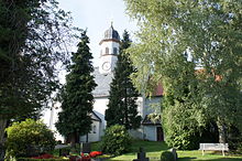
St. Martin Church
The village church of Lauterbach, consecrated to St. Martin , was built around 1495 as a Catholic chapel and was originally under the archpriesthood of Jochgrim-Stolpen. With the introduction of the Reformation, it came to the Ephorie Bischofswerda in 1559. With the end of the rule of the bishops of Meißen over Stolpen, the Lauterbach parish passed on to the Saxon electors, whose office in Stolpen also decided the pastoral position. Today, in addition to Lauterbach, the neighboring villages of Oberottendorf , Rückersdorf and Bühlau belong to the parish, which has a total of around 1200 members.
The St. Martin's Church consists of two parts, the eastern one being the older and already in the 12th / 13th centuries. Century. It is a simple hall church with a closed choir. In 1870 a major renovation took place, whereby the church received its current roof turret. Restoration work took place in 1981 and 1991.
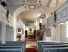
The furnishings are mainly from the 19th century. The church has a simple altar with two fluted columns with projecting beams. A round arch niche serves as a frame for the gilded wooden crucifix. The engraved plate below shows a representation of the Last Supper. There is a simple wooden pulpit on the south side of the choir. A goblet-shaped baptismal font and a wrought-iron lecture cross from 1748 and an organ built in 1923 in the Jehmlich family's workshop complete the equipment.
Three bells ring in the tower, which are dedicated to Mary Magdalene , St. Anne and the Virgin Mary . These were cast in 1513.
Easter column
A little outside of the village, near the exit from the village in the direction of Bühlau, at the intersection of Dorfstrasse and Niedere Strasse, there is the so-called "Easter column". It was probably created as a prayer or torture column in the pre-Reformation period.
In 1584 it was redesigned by Stolpen's official Thomas Treutzer in memory of a curious event in calendar history. In 1582 Pope Gregory XIII. introduced the Gregorian calendar , which was binding for Lusatia, Bohemia and Silesia from 1584. In neighboring Saxony, Saxony, however, the old Julian calendar still applied . As a result, in the border region between Saxony and Lusatia, Easter was celebrated twice within 10 days in 1584 .
The Easter column is about 2.50 meters high and bears the inscription: 1584 JAR THAT IS WAS ZVENE EASTER IN A JAR . On the left side there is also a reference to the restoration that took place in 1884. The square column is made of sandstone and has a cube-shaped top with a four-part roof. A representation of Christ can be seen on the front.
literature
- Richard Steche : Lauterbach. In: Descriptive representation of the older architectural and art monuments of the Kingdom of Saxony. 1. Booklet: Official Authority Pirna . CC Meinhold, Dresden 1882, p. 44.
Individual evidence
- ^ The mining between Lauterbach and Stolpen - accessed on March 17, 2013
- ↑ Website of the Lauterbach-Oberottendorf parish - accessed on March 17, 2013
- ↑ Ulrich Eichler: Marter and wayside shrine. Prayer columns in Saxony , Verlag DJM, 2003, ISBN 978-3980309196
Web links
- Data from the city of Stolpen - http://www.stolpen.de/stadt/lauterbach.phpWikisource: The Easter column near Lauterbach - sources and full texts
- Lauterbach in the Digital Historical Directory of Saxony


