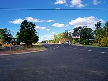
Leichhardt Highway
| Leichhardt Highway | |||||||||||||||||||||||||||||||||||||||||||||||||||||||||||||||||||||||||||||||||||||||||||||||||||||||||||||||||||||||||||||||||||||||||||
|---|---|---|---|---|---|---|---|---|---|---|---|---|---|---|---|---|---|---|---|---|---|---|---|---|---|---|---|---|---|---|---|---|---|---|---|---|---|---|---|---|---|---|---|---|---|---|---|---|---|---|---|---|---|---|---|---|---|---|---|---|---|---|---|---|---|---|---|---|---|---|---|---|---|---|---|---|---|---|---|---|---|---|---|---|---|---|---|---|---|---|---|---|---|---|---|---|---|---|---|---|---|---|---|---|---|---|---|---|---|---|---|---|---|---|---|---|---|---|---|---|---|---|---|---|---|---|---|---|---|---|---|---|---|---|---|---|---|---|---|
 
|
|||||||||||||||||||||||||||||||||||||||||||||||||||||||||||||||||||||||||||||||||||||||||||||||||||||||||||||||||||||||||||||||||||||||||||
| Basic data | |||||||||||||||||||||||||||||||||||||||||||||||||||||||||||||||||||||||||||||||||||||||||||||||||||||||||||||||||||||||||||||||||||||||||||
| Operator: | Dept. of Transport and Main Roads | ||||||||||||||||||||||||||||||||||||||||||||||||||||||||||||||||||||||||||||||||||||||||||||||||||||||||||||||||||||||||||||||||||||||||||
| Start of the street: |
|
||||||||||||||||||||||||||||||||||||||||||||||||||||||||||||||||||||||||||||||||||||||||||||||||||||||||||||||||||||||||||||||||||||||||||
| End of street: |
southwest of Westwood ( QLD ) ( 23 ° 40 ′ S , 150 ° 8 ′ E ) |
||||||||||||||||||||||||||||||||||||||||||||||||||||||||||||||||||||||||||||||||||||||||||||||||||||||||||||||||||||||||||||||||||||||||||
| Overall length: | 492 km | ||||||||||||||||||||||||||||||||||||||||||||||||||||||||||||||||||||||||||||||||||||||||||||||||||||||||||||||||||||||||||||||||||||||||||
|
States : |
|||||||||||||||||||||||||||||||||||||||||||||||||||||||||||||||||||||||||||||||||||||||||||||||||||||||||||||||||||||||||||||||||||||||||||
|
Course of the road
|
|||||||||||||||||||||||||||||||||||||||||||||||||||||||||||||||||||||||||||||||||||||||||||||||||||||||||||||||||||||||||||||||||||||||||||
The Leichhardt Highway is a trunk road in the east of the Australian state of Queensland. It runs in a south-north direction and is about 600 km long. The Leichhardt Highway got its name in honor of the Prussian explorer Ludwig Leichhardt . On his first Australian expedition from Brisbane to Port Essington in 1844 and 1845, Leichhardt used a route in the hinterland of the then known Queensland, which largely corresponds to the current course of the Leichhardt Highway.
course
The Leichhardt Highway begins in Goondiwindi on the border between New South Wales and Queensland. It is considered a continuation of the Newell Highway (N39), which reaches the city from the south.
The Leichhardt Highway runs north from Goondiwindi and crosses the Moonie Highway (S49) in the small town of Moonie after 95 km . After another 125 km, the Leichhardt Highway reaches the small town of Miles , where the Warrego Highway (NA2) crosses. Continuing north, the Leichhardt Highway makes its way through the Great Dividing Range, which is sometimes very winding .
The city of Theodore is reached after 225 km . It is named after the former Prime Minister of Queensland Ted Theodore . The special thing about this city is that it served Walter Burley Griffin , the architect of the Australian capital Canberra , as a kind of testing ground. When designing Theodore, he tried out some urban planning elements before determining the future look of Canberra.
50 km north of Theodore, the Leichhardt Highway crosses the Dawson Highway (S60) in the village of Banana , which is part of the connection between Gladstone and Emerald . From Banana it is another 110 km until the Leichhardt Highway meets and ends at the village of Westwood on the Capricorn Highway (A4).
The highest point on the highway is 413 m, the lowest is 96 m.
literature
- Steve Parish: Australian Touring Atlas . Steve Parish Publishing, Archerfield QLD 2007, ISBN 978-1-74193-232-4 , pp. 8, 9, 11
Web links
Individual evidence
- ↑ maps.bonzle.com - Leichhardt Highway . Retrieved April 19, 2012.
