
Leno di Terragnolo
| Leno di Terragnolo | ||
 The Torrente Leno di Terragnolo just before its mouth |
||
| Data | ||
| location | Trentino , Italy | |
| River system | Etsch | |
| Drain over | Torrente Leno → Etsch → Adriatic Sea | |
| River basin district | Eastern Alps | |
| source | in Malga Gulva in Pasubio 45 ° 49 '54 " N , 11 ° 11' 33" O |
|
| Source height | 1027 m slm | |
| muzzle | at San Colmbano in the Leno coordinates: 45 ° 52 '46 " N , 11 ° 3' 42" E 45 ° 52 '46 " N , 11 ° 3' 42" E |
|
| Mouth height | 235 m slm | |
| Height difference | 792 m | |
| Bottom slope | 44 ‰ | |
| length | 18 km | |
| Catchment area | 60 km² | |
| Left tributaries | Rio Praghim, Sarta, Pàssaul | |
| Right tributaries | Rio Borcola, Giordano, Ertile, Wasserthal, Valle dei Ponti, Val Calchere, Acqua Negra, Valgrande | |
| Reservoirs flowed through | Stedileri | |
| Communities | Terragnolo , Trambileno , Rovereto | |
The Leno di Terragnolo (German: Laim- or Leimbach) is a torrent (torrent) in northern Italy that flows through the Val Terragnolo in the province of Trento .
geography
geology
The catchment area consists mainly of limestone and dolomite , so that karst phenomena can be observed. Furthermore, it is characterized by various deposits, particularly of fluvio-glacial origin. In the past, these have repeatedly triggered landslides and contribute significantly to the sediment and loose rock that is washed into the stream bed during heavy rainfalls , which can be counteracted by appropriate hydraulic engineering measures.
course
The Leno di Terragnolo rises in the municipality of Terragnolo near the Malga Gulva southwest of the Passo della Borcola on the northern foothills of Monte Pasubio , which it borders on its north side. It first flows for a short distance in a north-easterly direction through the Val Gulva until the latter meets the Terragnolo valley and it turns north. At the level of the first localities near Incapo and Soldati, the Leno di Terragnolo takes a north-westerly direction in order to flow further in the middle course towards the west. In the lower reaches it forms the municipal boundary between the municipalities of Trambileno and Rovereto , here it again takes a slight north-westerly direction before flowing through a gorge and shortly afterwards flowing into the Leno di Vallarsa at San Colombano . The Torrente has deeply eroded the Kerbtal and the creek bed is partly very rugged. Only in places in the middle and especially in the lower reaches does the valley floor and the stream bed widen a little. In this flat area, the Leno di Terragnolo partly branches and there are also larger gravel banks . Otherwise, larger and smaller allochthonous boulders mark the stream bed.
The Leno di Terragnolo has several tributaries, mostly with seasonally strongly fluctuating water levels that remain dry for longer periods of time. The most important is the Rio Passaùl or Pazaul in the middle reaches of the Leno, which ensures a continuous noteworthy runoff.
history
On the Leno di Terragnolo was for centuries wood to Rovereto getriftet . It was mainly the Republic of Venice in the 15th century that expanded the timber trade. Due to the strongly fluctuating water level, the Leno could usually only be used for this purpose in spring after the snow had melted and in autumn during the rainiest season. During the rest of the time, the wood intended for drifting was stacked on its banks. With the expansion of the road network between the 19th and 20th centuries, drifting lost its importance and was finally discontinued.
In the past, the water from the Leno was also used for mills, forges and sawmills. From the 20th century on, electricity generation played an increasingly important role. As early as the First World War , the Austro-Hungarian army operated a small turbine on its central reaches , which supplied the electricity for a material ropeway.
In the 1920s, a weir with an inlet structure and pressure tunnel was built on its lower course at the beginning of the gorge , with which a small hydroelectric power station of the Jacob paper mill near Rovereto was fed.
At the end of the 1950s, a project for the use of hydropower in Leno di Terragnolo was presented first by the municipality of Verona and then by the municipality of Rovereto . From both projects, the CET (“Comunità elettrica di Terragnolo”) company, operated by both municipalities, emerged in the early 1960s and commissioned the San Colombano hydropower plant in the mid-1960s . For this purpose, which was on the middle reaches reservoirs Stedileri built. The latter is fed by the Leno and the Rio Pazzul and is connected to the power plant via a pressure tunnel. The pressure tunnel built in the lower reaches of the 1920s is also used by the new power plant. A reservoir in the upper reaches that was planned in the original project was not realized due to geological problems.
Even before the course of the Leno di Terragnolo was influenced by buildings for electricity generation , various flood protection measures had been implemented. Especially after two floods that occurred in quick succession in 1882. Presumably, however, barriers had already been carried out, of which, however, no traces have been preserved. These buildings, erected in the 19th century, were primarily intended to contain the alluvial material. During the severe floods of 1928, several landslides broke loose in the Leno catchment area, necessitating additional water protection structures at the Leno tributaries. There were other notable floods in 1953 and 1965.
environment
Despite the interventions carried out to generate electricity, the Leno di Terragnolo is considered a largely natural river course. This is mainly due to the fact that the valley floor in Val Terragnolo through which it flows is only exposed to low anthropic pressure. Only the two hamlets Sega and San Nicolò are on the edge of the valley floor, otherwise it is relatively untouched and only accessible by a few paths. The damming in the middle reaches, however, has a negative effect on the natural runoff, which in turn has an impact on the fish population.
In the Leno di Terragnolo there are brook trout in the upper reaches as well as marbled trout in the middle and lower reaches , whereby the original species are declining due to stocking with farmed trout . In addition, the Leno fish population is characterized by the greater presence of the bullhead .
The ecological status was classified as good in the observation period from 2010 to 2016.
photos

On the lower reaches of the hamlet of Ca 'Bianca

Stedileri reservoir
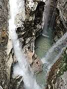
Leno Gorge

Weir with inlet structure at the beginning of the gorge

The so-called Lido in the lower reaches


literature
- APPA - Agenzia provinciale per la protezione dell'ambiente Trento (ed.): Le acque superficiali del territorio della: Comunità della Vallagarina . APPA, Trento 2017. (PDF)
- Renzo Dori: Le grandi derivazioni idroelettriche del Trentino. Fondazione Museo Storico del Trentino, Trento 2015, ISBN 978-88-7197-201-5 .
- Laura Mattevi: La geografia antropica della Valle di Terragnolo . Comune di Terragnolo, Rovereto 2008.
- Renza Miorandi: Monte Pasubio: i luoghi dell'acqua alla riscoperta delle sorgenti storiche . Osiride, Rovereto 2003, ISBN 88-7498-012-4 .
- Provincia autonoma di Trento, Azienda Speciale di Sistemazione Montana (ed.): Per una difesa del Territorio: La sistemazione dei bacini montani in provincia di Trento attraverso i secoli . Edizioni Arca, Trento 1991.
- Provincia autonoma di Trento, Servizio faunistico (ed.): Carta ittica del Trentino . Provincia autonoma di Trento, Trento 2002.
- Giuseppe Zanella: La Comunità elettrica del Terragnolo. In: I Quattro Vicariati. Rivista semestrale di cultura e vita. Anno XXXVIII - Numero 75 - Luglio 1994.
Web links
References and comments
- ↑ Laura Mattivi: La geografia antropica della Valle di Terragnolo. 2008, OCLC 878683442 , p. 11.
- ↑ Renza Miorandi: Monte Pasubio: i luoghi dell'acqua alla riscoperta delle sorgenti storiche. 2003, p. 40.
- ↑ Renza Miorandi: Monte Pasubio: i luoghi dell'acqua alla riscoperta delle sorgenti storiche. 2003, p. 39.
- ↑ The length data vary depending on the source from 15 to a maximum of 21 kilometers.
- ^ Provincia autonoma di Trento, Azienda Speciale di Sistemazione Montana (ed.): Per una difesa del Territorio: La sistemazione dei bacini montani in provincia di Trento attraverso i secoli. 1991, p. 170.
- ^ Provincia autonoma di Trento, Azienda Speciale di Sistemazione Montana (ed.): Per una difesa del Territorio: La sistemazione dei bacini montani in provincia di Trento attraverso i secoli. 1991, p. 171.
- ^ Giampietro Braga and others: Le valli del Leno: Vallarsa e valle di Terragnolo. 1990, pp. 133-136.
- ^ Giuseppe Zanella: La Comunità elettrica del Terragnolo. 1994, p. 83.
- ↑ Luciano Azzolini, Roberto Colletti, Mauro Lando: Energia nel Trentino: il lungo cammino dell'autonomia. 1983, p. 37.
- ^ Renzo Dori: Le grandi derivazioni idroelettriche del Trentino. 2015, pp. 254-259.
- ^ Provincia autonoma di Trento, Azienda Speciale di Sistemazione Montana (ed.): Per una difesa del Territorio: La sistemazione dei bacini montani in provincia di Trento attraverso i secoli. 1991, pp. 174-175.
- ^ Provincia autonoma di Trento, Servizio faunistico (ed.): Carta ittica del Trentino. 2002, pp. 82-83.
- ↑ APPA - Agenzia provinciale per la protezione dell'ambiente Trento (ed.): Le acque superficiali del territorio della: Comunità della Vallagarina. 2017, p. 41.