Lhota (Trutnov)
| Lhota | ||||
|---|---|---|---|---|
|
||||
| Basic data | ||||
| State : |
|
|||
| Region : | Královéhradecký kraj | |||
| District : | Trutnov | |||
| Municipality : | Trutnov | |||
| Area : | 334,595 ha | |||
| Geographic location : | 50 ° 35 ' N , 15 ° 59' E | |||
| Height: | 425 m nm | |||
| Residents : | 147 (2001) | |||
| Postal code : | 541 03 | |||
| License plate : | H | |||
| traffic | ||||
| Street: | Poříčí - Bezděkov | |||
| Railway connection: |
Trutnov střed – Teplice nad Metují Jaroměř – Lubawka |
|||
Lhota , 1949–1980: Lhota u Trutnova (German Welhotta ) is a district of the city of Trutnov in the Czech Republic. It is located five kilometers northeast of the city center of Trutnov and belongs to the Okres Trutnov .
geography
Lhota extends at the foot of the Jestřebí hory in the valley of the Lhotecký brook. To the north of the village, the Trutnov střed – Teplice nad Metují railway runs through the Petříkovický creek valley , the Lhota u Trutnova stop is in Peklo. In the west, the Jaroměř – Lubawka railway passes Lhota. In the north rises the Na Sádkách (544 m nm), in the east the Markoušovický hřeben (708 m nm), southeast the Hůra ( Bergkoppe , 622 m nm), in the south the Čížkovy Kameny ( goat back , 632 m nm) and west of the Zámecký Kopec ( Castle Hill , 452 m nm).
Neighboring towns are Debrné , Peklo and Petříkovice in the north, Bezděkov and Chvaleč in the north-east, Celestýn and Slavětín in the east, Markoušovice and Starý Sedloňov in the south-east, Sedmidomí, Nový Sedloňov and Bohuslavice in the south, Kouty in the south-west, Poříčetí and Záříčetiny in the west and Libeč in the northwest.
history
The first written mention of the village took place in 1515. Welhotta belonged to the possessions of the castle Skal , later called Katzenstein; However, it was separated from the rest of the dominion as an exclave between the grounds of the dominions Adersbach and Trautenau . In 1662 the newly founded Diocese of Königgrätz acquired the Katzenstein estate from Wilhelm Albrecht Kolowrat -Krakowsky as a donation for the cathedral chapter ; Bishop Matthäus Ferdinand Sobek von Bilenberg gave the estate the new name Bischofstein .
In 1833 the village Welhotta in the Königgrätzer Kreis consisted of 72 houses in which 427 people lived. There was a school in the village, which the children from Bösig attended , as well as a mill. The parish was Trautenau . Until the middle of the 19th century, the village remained subject to Gut Bischofstein.
After the abolition of patrimonial formed Welhotta / Lhota in 1849 with the hamlet Bösig / Bezděkov a municipality in the judicial district Trutnov . In 1868 the village was assigned to the Trautenau district . Bösig broke away from Welhotta in the 1880s and formed its own community. In 1900 658 people lived in Welhotta , in 1930 the community had 464 inhabitants. After the Munich Agreement , the German-speaking village was added to the German Reich in autumn 1938 and belonged to the Trautenau district until 1945 . In 1939 the community had 404 inhabitants. After the end of World War II in 1945, Lhota returned to Czechoslovakia and the German population was expelled . 1950 Lhota and Bezděkov were merged to form a municipality Lhota u Trutnova . The construction of the Poříčí thermal power station in 1957 had a decisive impact on the quality of life in Lhota and Bezděkov. The prevailing westerly winds caused the exhaust gases from the power station located behind the castle hill in the Aupa valley to build up and the ash emissions fell in the Lhotecký potok valley. In addition, Lhota was cut by an above-ground district heating line to Radvanice . The Marienkapelle in the center of the village including the statue of St. Johannes were demolished in the second half of the 20th century for the construction of a department store. On January 1, 1981, it was incorporated into Trutnov. In 1991 Lhota had 137 inhabitants. In 2001 the district consisted of 61 houses and had 147 inhabitants. Since the 1990s, the air quality in Lhota has improved thanks to the installation of modern exhaust filters in the power plant.
Local division
The district of Lhota consists of the basic settlement units Bezděkov ( Bösig ) and Lhota ( Welhotta ). The settlement of Peklo ( Hell , formerly Wiesenthal ) also belongs to Lhota .
The district is divided into the cadastral districts Bezděkov u Trutnova and Lhota u Trutnova .
Attractions
- Back of goats with numerous sandstone rocks ( sea of rocks )
- Numerous timbered houses
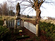
- Virgin Mary statue
- graveyard
- Memorial stone for the fallen of the First World War
- Lookout tower on the Markoušovický hřeben
- Castle stable at Zámecký Kopec
Web links
Individual evidence
- ↑ http://www.uir.cz/katastralni-uzemi/681237/Lhota-u-Trutnova
- ↑ Jiřina Růžková, Josef Škrabal, Vladimír Balcar, Radek Havel, Josef Křídlo, Marie Pavlíková, Robert Šanda: Historický lexikon obcí České republiky 1869–2005 (1st díl). Ed .: Český statistický úřad. Český statistický úřad, Prague 2006, ISBN 80-250-1310-3
- ^ Johann Gottfried Sommer , Franz Xaver Maximilian Zippe: The Kingdom of Böhmen. Statistically and topographically presented, vol. 4 Königgrätzer Kreis , Prague 1836, p. 164
- ↑ Michael Rademacher: German administrative history from the unification of the empire in 1871 to the reunification in 1990. Braunau district (Czech Broumov). (Online material for the dissertation, Osnabrück 2006).
- ↑ Vyhláška č. 13/1951 Sb. - Vyhláška ministra vnitra o změnách úředních názvů míst v roce 1950
- ↑ https://www.czso.cz/documents/10180/20565661/13810901.pdf/3fde2441-c81b-4a1e-9b94-551e65007f70?version=1.0
- ↑ http://www.uir.cz/zsj-casti-obce/081230/Cast-obce-Lhota
- ↑ http://www.uir.cz/casti-obce/081230/Lhota
- ↑ http://riesengebirgler.de/gebirge/Gefallene/Welhotta_Gef.htm


