
Lipot
| Lipot | |||||
|
|||||
| Basic data | |||||
|---|---|---|---|---|---|
| State : | Hungary | ||||
| Region : | Western Transdanubia | ||||
| County : | Győr-Moson-Sopron | ||||
| Small area until December 31, 2012 : | Mosonmagyaróvár | ||||
| District since 1.1.2013 : | Mosonmagyaróvár | ||||
| Coordinates : | 47 ° 52 ' N , 17 ° 28' E | ||||
| Area : | 16.09 km² | ||||
| Residents : | 659 (Jan. 1, 2011) | ||||
| Population density : | 41 inhabitants per km² | ||||
| Telephone code : | (+36) 96 | ||||
| Postal code : | 9233 | ||||
| KSH kódja: | 16221 | ||||
| Structure and administration (status: 2018) | |||||
| Community type : | local community | ||||
| Mayor : | József Péter Tóth (independent) | ||||
| Postal address : | Fő tér 2 9233 Lipót |
||||
| Website : | |||||
| (Source: A Magyar Köztársaság helységnévkönyve 2011. január 1st at Központi statisztikai hivatal ) | |||||


Lipót is a Hungarian community in the county Mosonmagyarovar in Győr-Moson-Sopron County .
Geographical location
The municipality is located on the right bank of the Danube on the Little Schüttinsel , 15 kilometers east of the city of Mosonmagyaróvár . The border with Slovakia runs two kilometers northeast along the Moson-Danube . Neighboring municipalities are Dunaremete, Darnózseli and Hédervár.
Attractions
- Local history museum ( Falumúzeum )
- Kastanienallee ( Gesztenyefasor )
- Statue of the Virgin Mary ( Mária Szobor ), created 1954
- Roman Catholic Church Szent Kelemen , built in 1777 (Baroque)
- Stone Cross ( Ásvány Úti Kereszt )
- Lipót thermal baths
traffic
Roads No. 1404, No. 1405 and No. 1411 meet in Lipót. The nearest railway station, Kimle- Károlyháza, is located southwest of the municipality.
literature
- Lipót - Településképi Arculati Kézikönyv. Edited by the municipal administration, Lipót 2018.
photos

Aerial view of the place
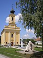
Roman Catholic Szent Kelemen Church

Virgin Mary statue

Kastanienallee
_l%C3%A9gi_fot%C3%B3n.jpg)


Web links
Commons : Lipót - collection of images, videos and audio files