Luma (inside)
|
Luma Lumi i Lumës |
||
|
In the Gryka e Vanave gorge |
||
| Data | ||
| location | Northeast Albania | |
| River system | Inside | |
| Drain over | Fierza Reservoir → Drin → Buna → Adria | |
| source | Confluence of Përroi i Orgjosit and Përroi i Topojanit 42 ° 1 '45 " N , 20 ° 31' 44" O |
|
| Source height | approx. 494 m above sea level A. | |
| muzzle |
Fierza Reservoir Coordinates: 42 ° 4 ′ 23 ″ N , 20 ° 27 ′ 0 ″ E 42 ° 4 ′ 23 ″ N , 20 ° 27 ′ 0 ″ E |
|
| Mouth height | 295 m above sea level A. | |
| Height difference | approx. 199 m | |
| Bottom slope | approx. 22 ‰ | |
| length | approx. 9 km | |
| Catchment area | 579 km² | |
| Drain |
MNQ MQ MHQ |
3.5 m³ / s 13 m³ / s 24 m³ / s |
| Small towns | Kukës | |
|
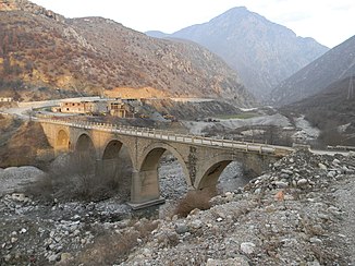
Old bridge over the Luma near Kukës |
||
|
Luma resp. Përroi i Topojanit near the village of Topojan, view towards the Kallabak |
||
The Luma ( Albanian Lume, Lumi i LUMES ) is a tributary river of the Drin in northern albania . It is the largest tributary of the Drin. It drains an area of 579 square kilometers in the northwest of the Šar Mountains , the core area of the Gora region . 225 square kilometers belong to Kosovo ( Dragash municipality ), the remaining 354 square kilometers to Albania ( Qark Kukës ). The mean height of the catchment area is 1420 m above sea level. A.
There are contradicting information about the length: All sources state that the Luma arises from the confluence of Përroi i Orgjosit and Përroi i Topojanit and has a length of 32.4 kilometers. The union of these two rivers is only around nine kilometers from the source. Also on sheet "34-66-C Morini" of the Albanian military map the lower course of the Përroi i Topojanit is marked as such, while on the adjoining sheet "K-34-78-A Shishtaveci" the same brook in higher sections with Lumi i Lumës is labeled. According to this map, the Luma arises much higher up through the confluence of mountain streams on the northern slopes of the Pllaja e Shishtavecit near the hamlet of Turaj, southeast of Shishtavec .
The Luma drains a large basin between high mountain ranges and mountain ranges . In the southeast the main ridge of the Šar Planina rises. In the south the Pllaja e Shishtavecit closes the catchment area with the Kallabak ( 2171 m above sea level ) as the highest point. To the south, the Çaja valley separates the catchment area from the Korab Mountains , which continues in the Gjallica ( 2485 m above sea level ) in the west and in the Koritnik ( 2393 m above sea level ) in the north . The Luma flows out of the basin through the narrow and over 1000 meter deep cut Gryka e Vanave ( Vanajva Gorge) . There is also a hydroelectric power station here . The gorge is protected as a national natural monument. Beyond the gorge, after a short run, the Luma flows into the Fierza reservoir near Kukës , previously just four kilometers further north into the White Drin .
The Luma and its tributaries mostly flow in deeply cut valleys, while the numerous small villages in the region are located at lower altitudes.
The name Luma is derived from the region of the same name around Kukës . The proximity to the Albanian word lum for river is confusing , from which the form Lumi i Lumës or Lumi Lumë , which is widespread in Albanian, is formed.
The catchment area is almost completely under nature protection . The Albanian side belongs to the Korab-Koritnik nature reserve , the Kosovar part of the Sharr National Park .
Individual evidence
- ↑ a b Official map 1: 50,000 of the military cartographic office of Albania, sheet K-34-66-C Morini , 2nd edition 1985
- ↑ Estimation, rough measurement on map
- ↑ a b c d e Niko Pano: Pasuritë ujore të Shqipërisë . Akademia e Shkencave e Shqipërisë , Tirana 2008, ISBN 978-99956-10-23-4 , pp. 209 .
- ↑ a b Akademia e Shkencave e RPSSH (ed.): Gjeografia fizike e Shqipërisë . tape 2 : Vështrim fiziko-gjeografik krahinor. Tirana 1991, p. 123 f .
- ↑ Ramazan Saraçi: Fjalor enciklopedik shqiptar . Ed .: Akademia e Shkencave e RPSSH . Tirana 1985, Lumi i Lumës, p. 650 f .
- ↑ Official map 1: 50,000 of the military cartographic office of Albania, sheet K-34-78-A Shishtaveci , 2nd edition 1985
- ↑ Natyror Korab-Kortnik Park. In: Agjencia Kombëtare e Zonave të Mbrojtura. Retrieved March 16, 2019 (Albanian).
- ^ Kuvendi i Republikës së Kosovës: Ligji No. 04 / L - 087 për Parkun Kombëtar Sharri . December 13, 2012, p. 2 ( kuvendikosoves.org [PDF; accessed March 16, 2019]).


