
Mühlenweg (Wallhalbtal)
| Mühlenweg in Wallhalbtal | |
|---|---|
 Mühlenweg with the Wallhalb in the foreground |
|
| Data | |
| length | 23 km |
| location | Germany |
| Starting point |
Landstuhl 49 ° 24 ′ 28.7 ″ N , 7 ° 34 ′ 16.9 ″ E |
| Target point |
Thaleischweiler frogs 49 ° 15 '34.4 " N , 7 ° 33' 4.6" E |
| Type | trail |
| The highest point | 400 m above sea level NHN |
| Lowest point | 245 m above sea level NHN |
| Level of difficulty | light |
| season | all year round |
| particularities | 13 mills, Wallhalbtal , Nanstein Castle |
The Mühlenweg in Wallhalbtal lies in the West Palatinate ( Rhineland-Palatinate ). It runs through the Sickinger height of the SICKINGEN city country chair over Wallhalben until after Thaleischweiler-frogs .
geography
course

The 23 km long hiking trail climbs steeply for the first 3 km from Landstuhler Bruch ( 248 m above sea level ). Above the Landstuhl Hospital, it reaches its highest point at 400 m . From there it runs to Mittelbrunn and then follows the Stuhlbach . Along this and - from Wallhalben - along the Wallhalb, the Mühlenweg has a continuous slight gradient that corresponds to that of the waters.
Parallel to the country road, the Mühlenweg leads directly past ten water mills . Two are located in Landstuhl aside and one further down the stream near the path, the surroundings of which partly enjoy the status of a landscape protection area. Some of the mills were supplied with water from tributaries from the Wallhalb catchment area and not from this itself. The Mühlenweg ends below the residential development of the Thaleischweiler district at 245 m , where the Wallhalb flows into the Schwarzbach .
Surroundings
A few kilometers west of the Mühlenweg, the meteorite trail ( Winterbach -
history
The Mühlenweg was created in 1978 and is a joint touristic project of the town and community of Landstuhl and the community of Thaleischweiler-Wallhalben . Since 1996, every two years in early summer - in the even years in which no Sickinger grumberry market is celebrated - the car-free Wallhalbtal adventure day takes place. The entire valley will then be closed to motorized traffic, and the roads are only free for cyclists, inline skaters and hikers. Even when the weather is not so good, 5000 guests come, and when the sun is shining it can be up to 15,000.
Mills and formerly supplied places
| # |
Mills from north to south |
Location to Mühlenweg (d = direct, a = apart) |
Formerly supplied places |
| 1. | Lower mill | a | Landstuhl |
| 2. | Upper mill | a | Landstuhl |
| 3. | Mittelbrunn mill | d | Mittelbrunn |
| 4th | Scharrmühle | d | Gerhardsbrunn |
| 5. | Knopper mill | d | Knopp-Labach |
| 6th | Cat mill | d | Oberhausen |
| 7th | Wallhalber mill | d | Wallhalben |
| 8th. | Würschhauser mill | d | former Werschhausen settlement |
| 9. | Konradsmühle | d | Herschberg |
| 10. | Kneisper mill | d | Maßweiler , Reifenberg , Schmitshausen , Oberhausen |
| 11. | Rosselmühle | d | |
| 12. | Weihermühle | a | Herschberg |
| 13. | Faustmill | d | Thaleischweiler |
Attractions
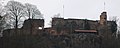
Nanstein Castle

Wallhalben wash fountain

One of the waterfalls in the Odenbachkessel


Nanstein Castle - Near the northern origin of the hiking trail is Nanstein Castle , where the besieged knight Franz von Sickingen was killed in 1523 .
Rosselmühle - Only in the oldest mill in the valley, the Rosselmühle , which was converted into a mill museum after its end of operation in 1986, is an original water wheel still in operation for demonstration purposes . Its first construction was probably before 1400, the current building dates from around 1720. Initially, the Rosselmühle was a bone mill , also known as a bone pounder, which produced bone meal as fertilizer for agriculture. With the advent of the chemical industry , it became the hemp rub rebuilt and later for flour mill .
Kneispermühle - The Kneispermühle , dating from 1440, was destroyed in the Thirty Years War and rebuilt in 1701. Today it is a restaurant where guests can rest under mighty horse chestnuts . In order to have enough drive water available even in dry periods, the Wallhalb was dammed up in front of the Kneispermühle to form a larger pond, a woog , which has been preserved to this day and contributes to the tranquil overall impression.
Wall Half Mill - The remarkable thing about the city, in the center of the eponymous village mill Wall Half is that the water over a 2.5 km long trench was brought in. Despite the abandonment of the flour mill, the bakery that was connected early on is still there.
Wash fountain - The fountain in Wallhalben bears his name because the village population had the opportunity to do their laundry there before water pipes were built.
Weihermühle - The Weihermühle , a little to the side of Herschberg , is operated as a country inn with pony and horse rental.
Wasserschaupfad and Odenbach-Kessel - The Wasserschaupfad begins right behind the Weihermühle and leads in a north-easterly direction over a few kilometers, first up the Schauerbach and then to the sources of the Odenbach . The area around its "basin", a high depression , is completely natural: large boulders covered with moss lie between dark spruce trees, between which the path meanders. The headwaters of the Odenbach stream their way through the rock formations. They overcome the rocks in audibly rushing cascades, the sparse sunlight is caught in the mist droplets.
Web links
- Sickinger Grumberry Market: “Mühlenweg” hiking experience in Wallhalbtal
Individual evidence
- ↑ The big bang will not be forgotten . In: Palatine Merkur . Zweibrücken July 20, 2009.
- ↑ Mühlenweg. (No longer available online.) Pfälzer Mühlenland, archived from the original on June 23, 2015 ; accessed on June 23, 2015 .